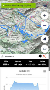
burnair Map

Contains ads
10K+
Downloads
Content rating
Everyone
Screenshot image
Screenshot image
Screenshot image
Screenshot image
Screenshot image
Screenshot image

About this app

burnair Map helps you plan your paragliding flight. Paraglider take-off and landing sites, thermal hotspots and lee areas are shown. You will also find suggestions for cross-country flights and explanations on how to overcome key points.
Updated on
10 May 2024

Data safety

Safety starts with understanding how developers collect and share your data. Data privacy and security practices may vary based on your use, region and age The developer provided this information and may update it over time.
This app may share these data types with third parties
Location and Personal info
This app may collect these data types
Location, Personal info and 2 others
Data is encrypted in transit
You can request that data be deleted

What's new

- IGC Download nun direkt vom Handy möglich
- Download von geplanten XC Flügen möglich