
土地相場検索マップ-ハザードマップとかさねて
Contains ads
100+
Downloads

Everyone
info


About this app
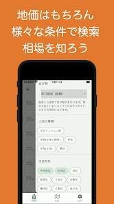
From the past transaction history, this app can find out which area's land is expensive or cheap.
Is it related to disaster information?
I made it because I wanted an app that I could look up while comparing them.
This app uses information from:
Geospatial Information Authority of Japan (https://www.gsi.go.jp/)
Ministry of Land, Infrastructure, Transport and Tourism real estate transaction price information (https://www.land.mlit.go.jp/webland/note.html)
Hazard map portal site (https://disaportal.gsi.go.jp/)
● Overview of usage
It is roughly divided into three items: "Land price information screen", "Map screen", and "Setting screen".
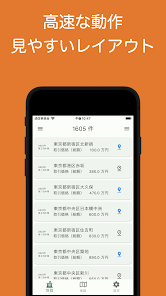
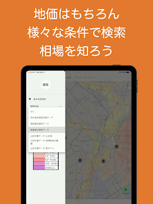
▲Land price information screen
You can see the transaction information of each prefecture acquired from "Land General Information".
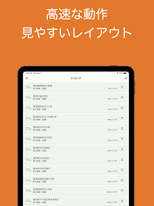
You can sort by various information such as transaction price, floor plan, and floor area.
Once acquired data is cached for 3 months, so the operation is smooth and comfortable.
You can add a pin to the real estate you like on this screen. The property can be seen on the next map screen.
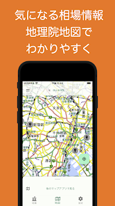
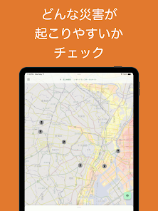
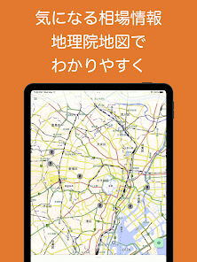
▲Map screen
You can intuitively check the location of the property examined on the land price information screen.
The maps used here are based on the information provided by the Geospatial Information Authority of Japan.
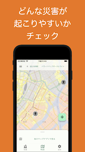
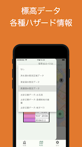
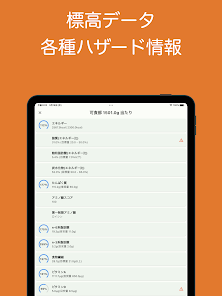
In accordance with the map, flood and inundation assumed area data, sand non-inundation assumed data, storm surge inundation assumed data, landslide disaster data
You can see them together.
▲Setting screen
Various setting screens.
● App overview
This app is the perfect tool to support your land search. We provide land price information and map data based on official land price data of the Ministry of Land, Infrastructure, Transport and Tourism. Furthermore, hazard maps and disaster information are also covered, making it possible to search for land with an emphasis on safety.
Real Estate Map offers a simple and easy-to-use interface. You can easily search within the app and instantly obtain the price, transaction price, and market information of the land you are interested in from past transaction information. The map uses the map of the Geospatial Information Authority of Japan to provide a visually easy-to-understand display.
In addition, the real estate information map also provides hazard maps such as rivers and tsunamis, supporting land searches that minimize disaster risk. For those who want to choose land with peace of mind, this app will be an essential tool.
Now let's find valuable land in the world of real estate. Download the real estate information map and get fast and accurate information. We will help you find the ideal land by eliminating the stress of searching for land. Please try this app!
* This app uses data from the Geospatial Information Authority of Japan, but the information provided in the app is for reference only and does not guarantee accuracy. We recommend that you consult with an expert when making final decisions regarding purchases or investments.
Is it related to disaster information?
I made it because I wanted an app that I could look up while comparing them.
This app uses information from:
Geospatial Information Authority of Japan (https://www.gsi.go.jp/)
Ministry of Land, Infrastructure, Transport and Tourism real estate transaction price information (https://www.land.mlit.go.jp/webland/note.html)
Hazard map portal site (https://disaportal.gsi.go.jp/)
● Overview of usage
It is roughly divided into three items: "Land price information screen", "Map screen", and "Setting screen".
▲Land price information screen
You can see the transaction information of each prefecture acquired from "Land General Information".
You can sort by various information such as transaction price, floor plan, and floor area.
Once acquired data is cached for 3 months, so the operation is smooth and comfortable.
You can add a pin to the real estate you like on this screen. The property can be seen on the next map screen.
▲Map screen
You can intuitively check the location of the property examined on the land price information screen.
The maps used here are based on the information provided by the Geospatial Information Authority of Japan.
In accordance with the map, flood and inundation assumed area data, sand non-inundation assumed data, storm surge inundation assumed data, landslide disaster data
You can see them together.
▲Setting screen
Various setting screens.
● App overview
This app is the perfect tool to support your land search. We provide land price information and map data based on official land price data of the Ministry of Land, Infrastructure, Transport and Tourism. Furthermore, hazard maps and disaster information are also covered, making it possible to search for land with an emphasis on safety.
Real Estate Map offers a simple and easy-to-use interface. You can easily search within the app and instantly obtain the price, transaction price, and market information of the land you are interested in from past transaction information. The map uses the map of the Geospatial Information Authority of Japan to provide a visually easy-to-understand display.
In addition, the real estate information map also provides hazard maps such as rivers and tsunamis, supporting land searches that minimize disaster risk. For those who want to choose land with peace of mind, this app will be an essential tool.
Now let's find valuable land in the world of real estate. Download the real estate information map and get fast and accurate information. We will help you find the ideal land by eliminating the stress of searching for land. Please try this app!
* This app uses data from the Geospatial Information Authority of Japan, but the information provided in the app is for reference only and does not guarantee accuracy. We recommend that you consult with an expert when making final decisions regarding purchases or investments.
Updated on
Safety starts with understanding how developers collect and share your data. Data privacy and security practices may vary based on your use, region and age The developer provided this information and may update it over time.


