
Ardenne Sports Nature
In-app purchases
1K+
Downloads

Everyone
info


About this app
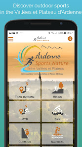
From the city of Rocroy to the Semoy valley, discover the Valleys and Plateau of Ardenne territory which gathers some of the most beautiful jewels of the Ardennes.
The application offers you trail running, hiking and mountain bike routes to discover the Vallées et Plateau d'Ardenne while practising your favourite activity.
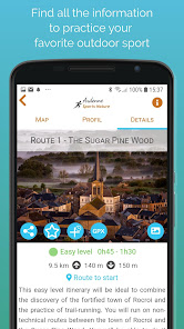
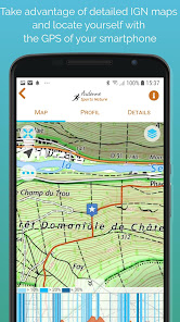
Once the app is installed, you will be able to download maps for offline use: Open Topo Maps or IGN maps. The application also includes all the routes and the associated altitude profiles.
Many features will help you practice the trail-running :
• get your location on the detailed IGN maps with the GPS
• training workouts
• record your chronos
• description of the route and points of interest
• monitoring alert to be notified if you move away from the route
• call or send an emergency SMS in case of problems
• sending predefined SMS to your contacts
• reporting a problem on the route
• adding comments
• sharing on social networks
• Weather in 5 days (Openweathermap)• module secours : déclenchement d’un appel ou envoi d’un SMS d’urgence en cas de problème
Access to all features requires that you use a Trace de Trail account.
Remark : Continued use of GPS running in the background can greatly decrease battery life.
The application offers you trail running, hiking and mountain bike routes to discover the Vallées et Plateau d'Ardenne while practising your favourite activity.
Once the app is installed, you will be able to download maps for offline use: Open Topo Maps or IGN maps. The application also includes all the routes and the associated altitude profiles.
Many features will help you practice the trail-running :
• get your location on the detailed IGN maps with the GPS
• training workouts
• record your chronos
• description of the route and points of interest
• monitoring alert to be notified if you move away from the route
• call or send an emergency SMS in case of problems
• sending predefined SMS to your contacts
• reporting a problem on the route
• adding comments
• sharing on social networks
• Weather in 5 days (Openweathermap)• module secours : déclenchement d’un appel ou envoi d’un SMS d’urgence en cas de problème
Access to all features requires that you use a Trace de Trail account.
Remark : Continued use of GPS running in the background can greatly decrease battery life.
Updated on
Safety starts with understanding how developers collect and share your data. Data privacy and security practices may vary based on your use, region and age The developer provided this information and may update it over time.

No data shared with third parties
Learn more about how developers declare sharing

This app may collect these data types
Personal info and Device or other IDs

Data isn’t encrypted

You can request that data be deleted
What's new
Fixes and improvements


