Radares da Amazônia - SIPAM
1K+
Downloads

Everyone
info
About this app
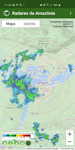
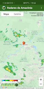
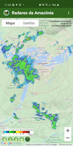
The “Radares da Amazônia” application allows you to view, in real time, radar images of the main cities in the Amazon.
With the tool, the user can see the movement of cloud formations in real time.
The application “Radares da Amazônia” brings an animation of the last five images of the radar, providing a better understanding of the advance of the weather conditions.
Using the user's GPS, it is possible to know if the rain is coming your way.
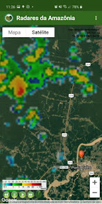
The user can choose the radar coverage radius and use satellite images in the background, providing a better geolocation of the rains.
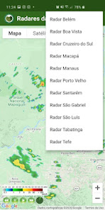
The radars have a 250km radius and are located in 10 municipalities in the Legal Amazon:
Boa Vista (RR)
Cruzeiro do Sul (AC)
Macapá (AP)
Manaus (AM)
Porto Velho (RO)
Santarém (PA);
São Gabriel da Cachoeira (AM)
Sao Luis (MA)
Tabatinga (AM)
Tefé (AM).
The “Radares da Amazônia” application is an official product of the Management and Operational Center of the Amazon Protection System (Censipam).
With the tool, the user can see the movement of cloud formations in real time.
The application “Radares da Amazônia” brings an animation of the last five images of the radar, providing a better understanding of the advance of the weather conditions.
Using the user's GPS, it is possible to know if the rain is coming your way.
The user can choose the radar coverage radius and use satellite images in the background, providing a better geolocation of the rains.
The radars have a 250km radius and are located in 10 municipalities in the Legal Amazon:
Boa Vista (RR)
Cruzeiro do Sul (AC)
Macapá (AP)
Manaus (AM)
Porto Velho (RO)
Santarém (PA);
São Gabriel da Cachoeira (AM)
Sao Luis (MA)
Tabatinga (AM)
Tefé (AM).
The “Radares da Amazônia” application is an official product of the Management and Operational Center of the Amazon Protection System (Censipam).
Updated on
Safety starts with understanding how developers collect and share your data. Data privacy and security practices may vary based on your use, region and age The developer provided this information and may update it over time.

No data shared with third parties
Learn more about how developers declare sharing

No data collected
Learn more about how developers declare collection
What's new
Correção de Bug Captura de Localização;
Ajuste do Icone;
Ajuste do Icone;
App support
phone
Phone number
+5569981147958


