
ReportFires
100+
Downloads

Everyone
info
About this app
ReportFires app helps users to make informed and timely responses to wildfires. It helps one to
-get notification of wildfires in one's area
-report wildfire quickly by simple map clicks
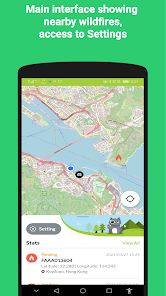
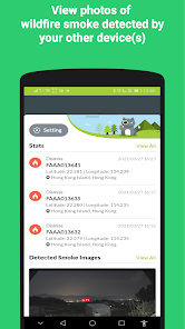
Users will receive real-time notification of wildfire within a 10km distance that is reported by other users. Users can view the wildfire location in the main map interface.
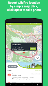
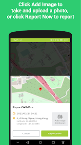
Users can quickly report wildfires they see by simple map clicks. Users can take and upload photos to provide more situational information about the wildfires.
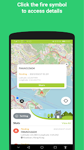
It is a crowdsourcing app for users to report fire locations. The red flame icon represents the reported fire location. The system will turn the flame icon to a grey color after 6 hours and will dismiss the icon after 48 hours. There are two statuses of any fire reported:
-pending: the fire reported is not verified
-verified: when authorized user verified it
There are three user types that all can receive and report wildfire information:
-Public user: can report wildfire with 5km distance
-Registered user: can report wildfire with 10km distance
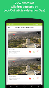
-Authorized user: can report wildfire within 100km distance. Can access the images reported and detected. It is for local government authority only. Please contact us at info@roboticscats.com for more details.
Wildfire information reported by the ReportFires app is also publicly available at reportfires.roboticscats.com.
ReportFires is not meant as a replacement for local evacuation alerts and information.
-get notification of wildfires in one's area
-report wildfire quickly by simple map clicks
Users will receive real-time notification of wildfire within a 10km distance that is reported by other users. Users can view the wildfire location in the main map interface.
Users can quickly report wildfires they see by simple map clicks. Users can take and upload photos to provide more situational information about the wildfires.
It is a crowdsourcing app for users to report fire locations. The red flame icon represents the reported fire location. The system will turn the flame icon to a grey color after 6 hours and will dismiss the icon after 48 hours. There are two statuses of any fire reported:
-pending: the fire reported is not verified
-verified: when authorized user verified it
There are three user types that all can receive and report wildfire information:
-Public user: can report wildfire with 5km distance
-Registered user: can report wildfire with 10km distance
-Authorized user: can report wildfire within 100km distance. Can access the images reported and detected. It is for local government authority only. Please contact us at info@roboticscats.com for more details.
Wildfire information reported by the ReportFires app is also publicly available at reportfires.roboticscats.com.
ReportFires is not meant as a replacement for local evacuation alerts and information.
Updated on
Safety starts with understanding how developers collect and share your data. Data privacy and security practices may vary based on your use, region and age The developer provided this information and may update it over time.

No data shared with third parties
Learn more about how developers declare sharing

This app may collect these data types
Location, Personal info and 3 others

Data is encrypted in transit

You can request that data be deleted
What's new
Bug fixes and performance improvements