
バスカーナビ by ナビタイム 大型バスが通れる道をご案内
In-app purchases
5K+
Downloads

Everyone
info


About this app
Car navigation app for large buses!
What is a bus car navigation
Specialized for large bus drivers, such as highly accurate estimated arrival time display, route search considering vehicle height, vehicle width, large vehicle regulations, etc., creation and saving of road plans, search for parking facilities for buses, etc. This is Japan's first car navigation app.
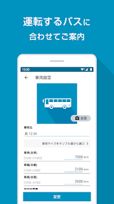
①Register the vehicle information of the bus you want to ride (up to 5 buses can be registered)
・ Vehicle height/width/length
・Gross vehicle weight / passenger capacity
・Automatically calculates vehicle classification and expressway toll classification from the above input values
② Passenger car regulation information nationwide
Search for a route considering traffic information
・Closed roads for large passenger vehicles: approximately 50,000 locations
・Various large vehicle regulations such as vehicle height/width: approximately 86,000 places
・Traffic information uses VICS and probe information (*)
*Accumulate driving logs of approximately 10 million km per day (= 250 laps of the earth) from NAVITIME's various car navigation services. Analyzing logs improves the accuracy of route searches.
③ Guidance on a safe route for large buses
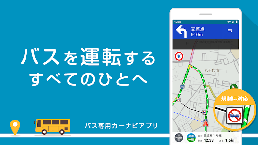
We will collect regulatory data for large passenger vehicles nationwide and guide you on routes that large buses can pass. Since the route is searched and guided according to the vehicle information of the bus you are driving, you can save the trouble of researching the roads that can be traveled in advance, and you can drive with confidence even on the first road.
■ Support bus drivers who operate sightseeing bus tours!
Based on the technology created by Navitime's navigation services such as Drive Supporter, Car Navi Time, and Truck Car Navi, we have added functions and various data for large bus drivers to pursue an operational feel that is suitable for business use. We support not only large buses, but also medium/small buses, minibuses, and passenger car sizes.
○ Functions unique to bus car navigation
・Map display of large passenger vehicle regulation information*
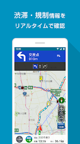
Places and roads that the set vehicle cannot pass are displayed on the map with icons and black lines. You can check the details by tapping the icon, and you can check the road closures/vehicle height/vehicle width/vehicle length/gross weight restrictions on the map.
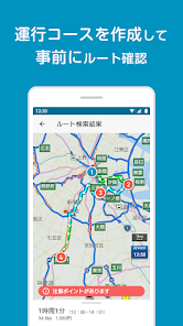
・Course Management*
・〜The day before the tour
You can register the destination and arrival and departure times according to the operation instructions, and check the route and travel time of the day in advance. The operation book is saved as a record, so you can use it by duplicating it or looking back.
・On the day of the tour
Start the operation of the course registered in advance. We will navigate between each destination and support the tour to the end of the day.
・Traffic information*
You can check the traffic congestion on the map, and you can also grasp the traffic congestion situation and lane restrictions on the road. By tapping the traffic jam line, you can also check detailed information about traffic jams, such as accidents and natural traffic jams.
・Large bus parking lot search
You can search about 1,500 large bus parking lots nationwide.
・Sightseeing spot search
You can search for sightseeing spots around your current location, by designated area, or by genre. (Approx. 32,000 cases)
・Fleet system SS search
Easy search for gas stations. You can also search by narrowing down brands from your current location and display icons on the map. Reliable even when refueling.
· Brands that can be displayed on the map
Enex Fleet/West Japan Fleet/Taiyo Koyu
Eneo Swing/Kitaseki/Idemitsu Kosan
Eneos/Cosmo Oil/Kygnus Oil
Showa Shell/Taiyo Oil (SOLATO)
JA-SS/Itochu/Usami
・Aerial/satellite photo display
It is useful for checking the parking lot and road width of the facility.
・Horizontal setting
You can search for a route with the destination on the left.
・Boarding/disembarking IC designation
You can specify the boarding IC, exiting IC, and JCT via JCT, and set the high-speed use section in detail. Even if expressway tolls are limited, you can choose a route while checking the expressway section and tolls.
・My location*
You can register frequently visited places as favorites as My places.
・Weather information map
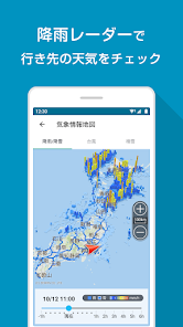
It is possible to check the situation of rainfall (rain clouds) snowfall, typhoons, and snowfall on a national map.
■ Main function list
○Traffic Information
・Congestion line display*
・Road traffic information*
・Control information*
・Highway and general road live cameras
・Traffic map*
○Point Search
・Free word/address/genre/phone number
・Sightseeing spot search
・Sightseeing bus parking lot search
・Emergency spot search such as toilets and hospitals
○Map
・Traffic closures for large passenger vehicles, etc.
Display of restricted sections by vehicle height/vehicle width/vehicle length/gross weight*
・Easy-to-read map
・Aerial/satellite photography
・Rain (rain cloud)/snow radar
・Snow map
・Typhoon map
・Automatic update of map information
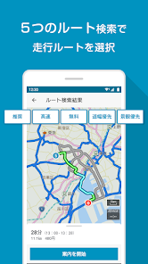
○Route search
・Horizontal setting
・Maximum speed setting
・Designated boarding/alighting IC
・Route search
├ Recommended route
├ High-speed priority route*
├ Free priority route*
├ Road width priority route*
└ Scenic priority route*
(consideration of traffic congestion) *
○Navigation*
・Voice navigation
・Speed limit display
・ SA/PA congestion information (for large car parking lots)
・Weather information
・Railway crossing guidance
・Information on accident-prone locations
・Orbis information
Others
・Vehicle registration (up to 5 can be registered)*
*Paid features (some can be used for free)
■Other Information
Compatible Vehicles
The scope of this application is classified by the Road Traffic Law into ordinary passenger cars, semi-medium passenger cars, medium passenger cars, and large passenger cars. It does not correspond to combined vehicles and special vehicles that exceed the general restrictions under the Road Act.
Payment method
Membership registration supports the following payment methods:
・Google Play payment [840 yen per month]
└ You cannot purchase with a "Google Play Gift Card".
★ Only for the first registration, there are benefits such as a free period for each billing type.
・Corporate contract
If many drivers are used in a company, a profitable corporate contract is also possible.
Click here for details
https://inquiry.navitime.co.jp/payment/inquiry.html?from=android_store
Operating Environment
・Device with Android 7.0 or higher
- Data communication is required for use.
- Voice route guidance is only available on GPS-equipped devices.
【important】
There is a problem that the page is not displayed for those who are using some terminals.
If the issue occurs, please try the following operations.
Access GooglePlay store ⇒ Search for "Android system WebView" app ⇒ Update
What is a bus car navigation
Specialized for large bus drivers, such as highly accurate estimated arrival time display, route search considering vehicle height, vehicle width, large vehicle regulations, etc., creation and saving of road plans, search for parking facilities for buses, etc. This is Japan's first car navigation app.
①Register the vehicle information of the bus you want to ride (up to 5 buses can be registered)
・ Vehicle height/width/length
・Gross vehicle weight / passenger capacity
・Automatically calculates vehicle classification and expressway toll classification from the above input values
② Passenger car regulation information nationwide
Search for a route considering traffic information
・Closed roads for large passenger vehicles: approximately 50,000 locations
・Various large vehicle regulations such as vehicle height/width: approximately 86,000 places
・Traffic information uses VICS and probe information (*)
*Accumulate driving logs of approximately 10 million km per day (= 250 laps of the earth) from NAVITIME's various car navigation services. Analyzing logs improves the accuracy of route searches.
③ Guidance on a safe route for large buses
We will collect regulatory data for large passenger vehicles nationwide and guide you on routes that large buses can pass. Since the route is searched and guided according to the vehicle information of the bus you are driving, you can save the trouble of researching the roads that can be traveled in advance, and you can drive with confidence even on the first road.
■ Support bus drivers who operate sightseeing bus tours!
Based on the technology created by Navitime's navigation services such as Drive Supporter, Car Navi Time, and Truck Car Navi, we have added functions and various data for large bus drivers to pursue an operational feel that is suitable for business use. We support not only large buses, but also medium/small buses, minibuses, and passenger car sizes.
○ Functions unique to bus car navigation
・Map display of large passenger vehicle regulation information*
Places and roads that the set vehicle cannot pass are displayed on the map with icons and black lines. You can check the details by tapping the icon, and you can check the road closures/vehicle height/vehicle width/vehicle length/gross weight restrictions on the map.
・Course Management*
・〜The day before the tour
You can register the destination and arrival and departure times according to the operation instructions, and check the route and travel time of the day in advance. The operation book is saved as a record, so you can use it by duplicating it or looking back.
・On the day of the tour
Start the operation of the course registered in advance. We will navigate between each destination and support the tour to the end of the day.
・Traffic information*
You can check the traffic congestion on the map, and you can also grasp the traffic congestion situation and lane restrictions on the road. By tapping the traffic jam line, you can also check detailed information about traffic jams, such as accidents and natural traffic jams.
・Large bus parking lot search
You can search about 1,500 large bus parking lots nationwide.
・Sightseeing spot search
You can search for sightseeing spots around your current location, by designated area, or by genre. (Approx. 32,000 cases)
・Fleet system SS search
Easy search for gas stations. You can also search by narrowing down brands from your current location and display icons on the map. Reliable even when refueling.
· Brands that can be displayed on the map
Enex Fleet/West Japan Fleet/Taiyo Koyu
Eneo Swing/Kitaseki/Idemitsu Kosan
Eneos/Cosmo Oil/Kygnus Oil
Showa Shell/Taiyo Oil (SOLATO)
JA-SS/Itochu/Usami
・Aerial/satellite photo display
It is useful for checking the parking lot and road width of the facility.
・Horizontal setting
You can search for a route with the destination on the left.
・Boarding/disembarking IC designation
You can specify the boarding IC, exiting IC, and JCT via JCT, and set the high-speed use section in detail. Even if expressway tolls are limited, you can choose a route while checking the expressway section and tolls.
・My location*
You can register frequently visited places as favorites as My places.
・Weather information map
It is possible to check the situation of rainfall (rain clouds) snowfall, typhoons, and snowfall on a national map.
■ Main function list
○Traffic Information
・Congestion line display*
・Road traffic information*
・Control information*
・Highway and general road live cameras
・Traffic map*
○Point Search
・Free word/address/genre/phone number
・Sightseeing spot search
・Sightseeing bus parking lot search
・Emergency spot search such as toilets and hospitals
○Map
・Traffic closures for large passenger vehicles, etc.
Display of restricted sections by vehicle height/vehicle width/vehicle length/gross weight*
・Easy-to-read map
・Aerial/satellite photography
・Rain (rain cloud)/snow radar
・Snow map
・Typhoon map
・Automatic update of map information
○Route search
・Horizontal setting
・Maximum speed setting
・Designated boarding/alighting IC
・Route search
├ Recommended route
├ High-speed priority route*
├ Free priority route*
├ Road width priority route*
└ Scenic priority route*
(consideration of traffic congestion) *
○Navigation*
・Voice navigation
・Speed limit display
・ SA/PA congestion information (for large car parking lots)
・Weather information
・Railway crossing guidance
・Information on accident-prone locations
・Orbis information
Others
・Vehicle registration (up to 5 can be registered)*
*Paid features (some can be used for free)
■Other Information
Compatible Vehicles
The scope of this application is classified by the Road Traffic Law into ordinary passenger cars, semi-medium passenger cars, medium passenger cars, and large passenger cars. It does not correspond to combined vehicles and special vehicles that exceed the general restrictions under the Road Act.
Payment method
Membership registration supports the following payment methods:
・Google Play payment [840 yen per month]
└ You cannot purchase with a "Google Play Gift Card".
★ Only for the first registration, there are benefits such as a free period for each billing type.
・Corporate contract
If many drivers are used in a company, a profitable corporate contract is also possible.
Click here for details
https://inquiry.navitime.co.jp/payment/inquiry.html?from=android_store
Operating Environment
・Device with Android 7.0 or higher
- Data communication is required for use.
- Voice route guidance is only available on GPS-equipped devices.
【important】
There is a problem that the page is not displayed for those who are using some terminals.
If the issue occurs, please try the following operations.
Access GooglePlay store ⇒ Search for "Android system WebView" app ⇒ Update
Updated on
Safety starts with understanding how developers collect and share your data. Data privacy and security practices may vary based on your use, region and age The developer provided this information and may update it over time.


What's new
■ 1.20.0での案内時にクラッシュが発生する不具合を修正いたしました


