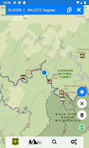
Visitor Map - USFS Lands
2.9star
178 reviews
50K+
Downloads

Everyone
info
About this app
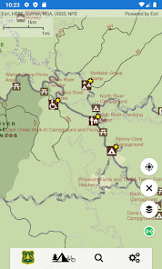
Explore the great outdoors by visiting America’s backyard -- 193 million acres of national forests and grasslands. Find your perfect spot on these expansive lands that include more than 4,300 campgrounds and 158,000 miles of trails, including 31,900 miles on pristine wilderness areas.
Discover our rich cultural heritage at such destinations as Chimney Rock National Monument. Step back into time by stepping on tracks left 150 million years ago by dinosaurs at the Picket Wire Trail in southeast Colorado, where you also can see Native American rock art, ruins from the Dolores Mission and Cemetery and the old Rourke cattle ranch.
These lands also play host to more than 6,000 miles of wild and scenic rivers that offer leisurely rides passed awe-inspiring scenery or breathtaking rollercoaster-like rides down rapids. We are your year-round destination, including skiing on one of the 122 ski areas in the winter, photographing the bursting colors of wildflowers, cooking s’mores around the campfire in the summer or watching leaves change colors in the fall.
Notable app. features include:
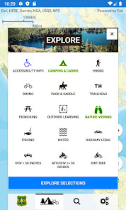
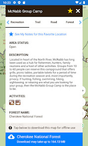
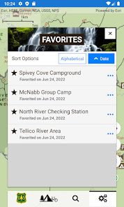
* accessible recreation locations
* simplified and streamlined map interface
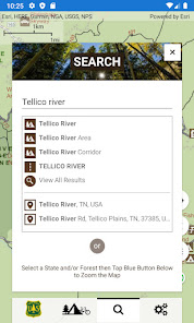
* national-level search capabilities
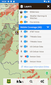
* wildfire and weather warnings/watches
* easily share the map through email or on social networks
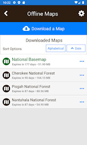
* offline mapping
Discover our rich cultural heritage at such destinations as Chimney Rock National Monument. Step back into time by stepping on tracks left 150 million years ago by dinosaurs at the Picket Wire Trail in southeast Colorado, where you also can see Native American rock art, ruins from the Dolores Mission and Cemetery and the old Rourke cattle ranch.
These lands also play host to more than 6,000 miles of wild and scenic rivers that offer leisurely rides passed awe-inspiring scenery or breathtaking rollercoaster-like rides down rapids. We are your year-round destination, including skiing on one of the 122 ski areas in the winter, photographing the bursting colors of wildflowers, cooking s’mores around the campfire in the summer or watching leaves change colors in the fall.
Notable app. features include:
* accessible recreation locations
* simplified and streamlined map interface
* national-level search capabilities
* wildfire and weather warnings/watches
* easily share the map through email or on social networks
* offline mapping
Updated on
Safety starts with understanding how developers collect and share your data. Data privacy and security practices may vary based on your use, region, and age. The developer provided this information and may update it over time.

No data shared with third parties
Learn more about how developers declare sharing

No data collected
Learn more about how developers declare collection
Ratings and reviews
3.0
171 reviews

Cris Clark
- Flag inappropriate
- Show review history
July 2, 2024
Works well for locating position, but doesn't navigate. Loads slow. Constantly saying app isn't responding, even after a clean reinstall. Very annoying to have to redownload offline maps every 90 days, now that I need to update , app errors out and says the maps aren't available. I've updated in the past, so new release? I even uninstalled and reinstalled, but same problem.
2 people found this review helpful

m
- Flag inappropriate
July 29, 2023
Great tool for those looking to explore the national forests. It's not as smart as google maps but is way more detailed. Half of the roads I've been on didn't even load on maps. Feature requests as of 7/29: Highlighting routes, can already highlight individual roads but not more than one at a time. Dispersed camping dots, slightly annoying that I need to stop by the park ranger office but not a deal breaker. Be able to orientat the app upsidedown.
9 people found this review helpful

Marni Herreid
- Flag inappropriate
January 13, 2021
Large and often difficult to find what I'm looking for, but when I get there, it does provide a lot of useful info: motor vehicle use maps - MVUs - old logging roads, for the most part; campgrounds; areas where primitive camping is allowed - which they call Dispersed camping; picnic areas, etc. Because it's such a huge file, I usually uninstall it after I've found what I need, and reinstall it when I need it again.
23 people found this review helpful
What's new
New test build of IVM.


