SurveyGPS SIMA,SFC読込~GPSで既知点調査
100+
Downloads

Everyone
info
About this app
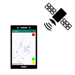
Convenient for reference point selection work. You can search for known points with GPS, register new point positions with GPS, connect, and output with SIMA. You can also check the coordinates on the spot by putting the coordinates in the terminal.
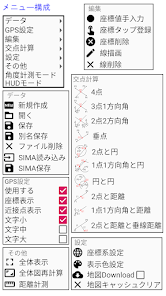
File
Create New - Discard the current data.
Open - Open the saved data (the previously saved data will automatically open at startup)
Save - save the data.
Save as - Save the data under a different name.
File delete - Delete the saved file.
SIMA read - read SIMA files.
SIMA Save - Outputs the current data to a SIMA file.
SFC read - read the SFC file.
SFC data clear Discards the read SFC.
GPS settings
Use - use GPS.
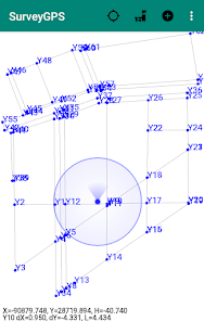
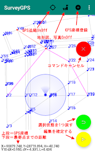
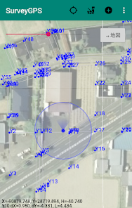
Coordinate display-Converts GPS coordinates into planar rectangular coordinates and displays them.
Proximity point display-Displays the distance to the point closest to the GPS coordinates.
Character ○ - Change the character size of the GPS coordinates.
edit
Manual input of coordinate values - Manually input plane rectangular coordinates.
Coordinate tap registration-Tap the coordinates on the screen to register them.
Delete Coordinates - Select and delete coordinates on the screen.
Line drawing - Select points on the screen and connect them.
Delete line - Select and delete a line on the screen.
intersection calculation
"Do various intersection calculations."
setting
Coordinate system setting - Set the local plane rectangular coordinate system.
Display color setting - Set the display color of points, lines, etc.
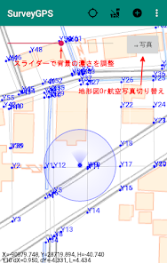
Map Download - background map download OnOff
Clear Map Cache Deletes downloaded background maps and photos.
others
Whole display-Displays the whole.
Overview recalculation-Recalculate the entire display area with the current coordinates.
Distance and angle measurement-Measure the distance between points and the angle of 3 points.
Coordinate list confirmation-Display the coordinate list (X, Y, H).
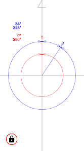
Angle measurement mode
Measure the approximate angle on site.
HUD mode
"Heads-up display mode." Regarding accidents while using a car,
"We do not take any responsibility."
"Press and hold to change the color of the text." (three-color loop)
"Flick to reverse the characters."
privacy policy
You can check the privacy policy of this app on the website.
* There are restrictions on folders that can be used depending on the OS version.
*Since the SFC reading function was originally created, there is a possibility that the display may become strange. (Only points, lines, circles, arcs, and text are displayed. Monochrome display. Text is displayed horizontally. Line types have their own spacing.)
* You can check the coordinates by pressing and holding the point on the screen.
*Please check the coordinate system if the GPS position and the position of the local point are significantly separated.
* GPS accuracy depends on the accuracy of the terminal.
* Map data will be accumulated in the built-in storage.
Communication charges will be incurred, so if you want to save money, you can save by downloading the necessary local range in advance in the Wifi environment.
If the terminal capacity is low, please clear the background data.
* When downloading the map, please operate slowly.
You may not be able to download normally.
File
Create New - Discard the current data.
Open - Open the saved data (the previously saved data will automatically open at startup)
Save - save the data.
Save as - Save the data under a different name.
File delete - Delete the saved file.
SIMA read - read SIMA files.
SIMA Save - Outputs the current data to a SIMA file.
SFC read - read the SFC file.
SFC data clear Discards the read SFC.
GPS settings
Use - use GPS.
Coordinate display-Converts GPS coordinates into planar rectangular coordinates and displays them.
Proximity point display-Displays the distance to the point closest to the GPS coordinates.
Character ○ - Change the character size of the GPS coordinates.
edit
Manual input of coordinate values - Manually input plane rectangular coordinates.
Coordinate tap registration-Tap the coordinates on the screen to register them.
Delete Coordinates - Select and delete coordinates on the screen.
Line drawing - Select points on the screen and connect them.
Delete line - Select and delete a line on the screen.
intersection calculation
"Do various intersection calculations."
setting
Coordinate system setting - Set the local plane rectangular coordinate system.
Display color setting - Set the display color of points, lines, etc.
Map Download - background map download OnOff
Clear Map Cache Deletes downloaded background maps and photos.
others
Whole display-Displays the whole.
Overview recalculation-Recalculate the entire display area with the current coordinates.
Distance and angle measurement-Measure the distance between points and the angle of 3 points.
Coordinate list confirmation-Display the coordinate list (X, Y, H).
Angle measurement mode
Measure the approximate angle on site.
HUD mode
"Heads-up display mode." Regarding accidents while using a car,
"We do not take any responsibility."
"Press and hold to change the color of the text." (three-color loop)
"Flick to reverse the characters."
privacy policy
You can check the privacy policy of this app on the website.
* There are restrictions on folders that can be used depending on the OS version.
*Since the SFC reading function was originally created, there is a possibility that the display may become strange. (Only points, lines, circles, arcs, and text are displayed. Monochrome display. Text is displayed horizontally. Line types have their own spacing.)
* You can check the coordinates by pressing and holding the point on the screen.
*Please check the coordinate system if the GPS position and the position of the local point are significantly separated.
* GPS accuracy depends on the accuracy of the terminal.
* Map data will be accumulated in the built-in storage.
Communication charges will be incurred, so if you want to save money, you can save by downloading the necessary local range in advance in the Wifi environment.
If the terminal capacity is low, please clear the background data.
* When downloading the map, please operate slowly.
You may not be able to download normally.
Updated on
Safety starts with understanding how developers collect and share your data. Data privacy and security practices may vary based on your use, region and age The developer provided this information and may update it over time.

No data shared with third parties
Learn more about how developers declare sharing

No data collected
Learn more about how developers declare collection
What's new
20230713 SFC読み込み、座標リスト表示機能追加
20210326 写真ダウンロード元変更、交点計算追加
20210222 不具合の修正、表示色変更機能追加
20210219 不具合の修正
20210205 背景地図表示設定追加
20200118 不具合の修正
20200116 機能追加
20190902 不具合の修正
20190820 パーミッション許可の修正
20190819 軽微な修正
20190809 機能追加
20190723 公開開始
20210326 写真ダウンロード元変更、交点計算追加
20210222 不具合の修正、表示色変更機能追加
20210219 不具合の修正
20210205 背景地図表示設定追加
20200118 不具合の修正
20200116 機能追加
20190902 不具合の修正
20190820 パーミッション許可の修正
20190819 軽微な修正
20190809 機能追加
20190723 公開開始