
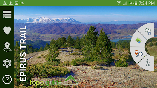
Epirus Trail
1 Tsg.+
Downloads

Jedes Alter
info


Über diese App
Epirus Trail is a long mountain adventure crossing the Epirus Region, from Mt. Gramos to Tzoumerka Mts.
Dream of many people for many years, its design began in 2015 by the Epirus Region authority and EPIRUS SA Development Company.
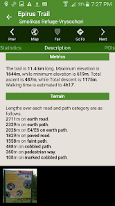
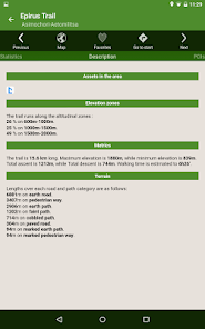
With a length of 370 km, Epirus Trail is the longest single hiking route ever developed in Greece.
Epirus Trail based on and highlights the old communication roads, used for centuries by local people to travel across Epirus.
The regions crossed by Epirus Trail include areas of exceptional natural scenery, unique ecological value and genuine cultural elements.
Epirus Trail is divided into three sections:
- The Eastern section starts in Konitsa, loops around Gramos and ends in Metsovo.
- The Western section crosses Mount Timfi and the Zagori area and ends in Metsovo as well.
- The Southern section bridges the mountainous zone between Metsovo and Kataraktis in the Tzoumerka area.
Epirus Trail is under development. No specific waymarking is available, nor all connections are feasible. Only some parts of the trail, mostly in the Zagori and Metsovo area, are already open to hikers. You walk at your own risk.
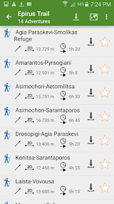
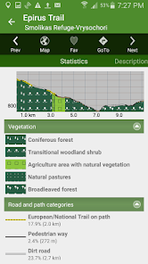
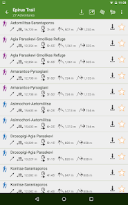
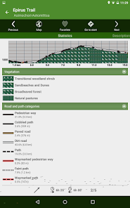
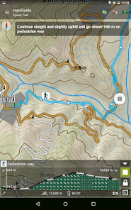
The application offers active navigation, descriptions and photos for the 28 daily sections. Each trail has an elevation profile, a statistic analysis, a detailed description, several photos and a POI list.
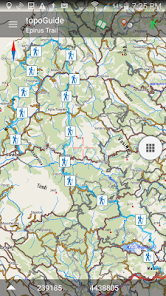
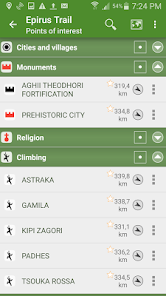
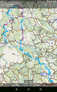
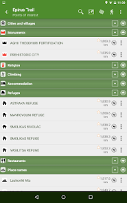
The app also provides detailed offline maps and a useful list of POIs with a comprehensive search engine.
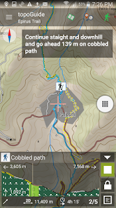
In the field, the app identifies the nearest adventure, guides you to it and then along it by displaying messages and warnings on every junction or other important location. On each Point of Interest, photos and texts are displayed on the map. If the hiker gets off-trail, the app indicates the shorter way to get back safely.
Dream of many people for many years, its design began in 2015 by the Epirus Region authority and EPIRUS SA Development Company.
With a length of 370 km, Epirus Trail is the longest single hiking route ever developed in Greece.
Epirus Trail based on and highlights the old communication roads, used for centuries by local people to travel across Epirus.
The regions crossed by Epirus Trail include areas of exceptional natural scenery, unique ecological value and genuine cultural elements.
Epirus Trail is divided into three sections:
- The Eastern section starts in Konitsa, loops around Gramos and ends in Metsovo.
- The Western section crosses Mount Timfi and the Zagori area and ends in Metsovo as well.
- The Southern section bridges the mountainous zone between Metsovo and Kataraktis in the Tzoumerka area.
Epirus Trail is under development. No specific waymarking is available, nor all connections are feasible. Only some parts of the trail, mostly in the Zagori and Metsovo area, are already open to hikers. You walk at your own risk.
The application offers active navigation, descriptions and photos for the 28 daily sections. Each trail has an elevation profile, a statistic analysis, a detailed description, several photos and a POI list.
The app also provides detailed offline maps and a useful list of POIs with a comprehensive search engine.
In the field, the app identifies the nearest adventure, guides you to it and then along it by displaying messages and warnings on every junction or other important location. On each Point of Interest, photos and texts are displayed on the map. If the hiker gets off-trail, the app indicates the shorter way to get back safely.
Aktualisiert am
Was die Sicherheit angeht, solltest du nachvollziehen, wie Entwickler deine Daten erheben und weitergeben. Die Datenschutz- und Sicherheitspraktiken können je nach Verwendung, Region und Alter des Nutzers variieren. Diese Informationen wurden vom Entwickler zur Verfügung gestellt und können jederzeit von ihm geändert werden.

Keine Daten werden mit Drittunternehmen oder -organisationen geteilt

Keine Daten erhoben
Neuigkeiten
Thank you for using our app!
This version fixes small bugs.
This version fixes small bugs.
Support für diese App
Informationen zum Entwickler
Adamakopoulos Triantafyllos
contact@topoguide.gr
Souliou 59
Agia Paraskevi ATTIKI
ATHENS 15343
Greece
undefined

