
Sailor Surface Pressure Charts

1 Tsg.+
Downloads

Jedes Alter
info


Über diese App
For proper planning of your sailing trip, information on meteo conditions are indispensable. The Sailtools Surface Pressure Charts App will give you a 5-day outlook on the possible developments of the large scale meteo conditions in Europe.
The maps have the purpose to merely supply you with large scale, longer term meteo info. To assess local actual conditions you will have to consult other sources.
To be able to download the charts in marginal internet connectivity conditions, the charts are supplied as low-resolution images, minimizing the file size.
Higher resolution images and zooming capability would suggest a reliability of the model outputs at a smaller scale. This has been discouraged by the meteorologists involved.
The app is light, fast and very easy to use. Morever it is free and without ads!
Features:
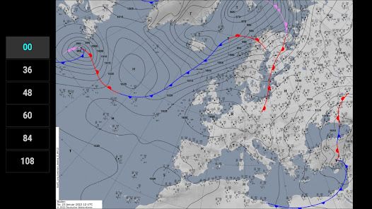
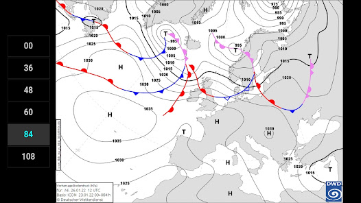
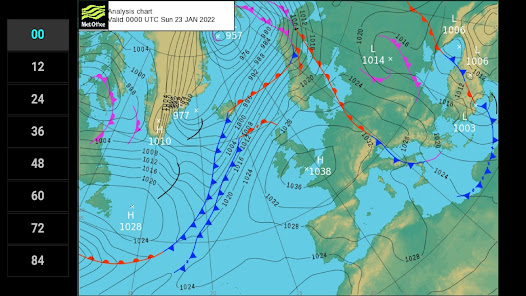
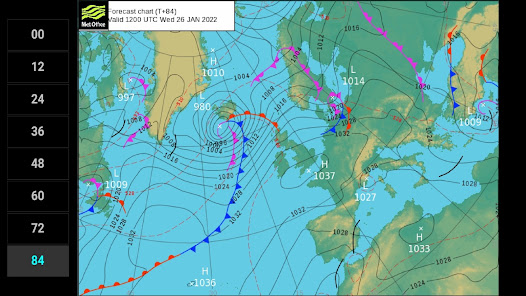
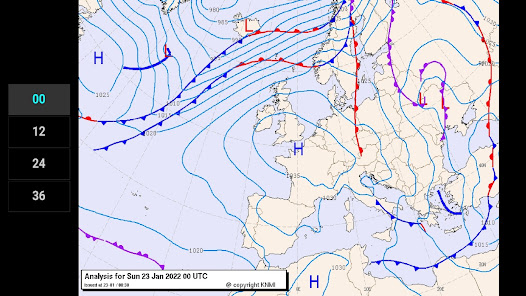
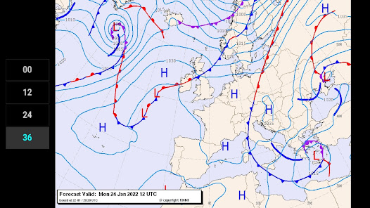
• DWD analysis for +00 and forecasts for 36, 48, 60, 84 and 108 hours
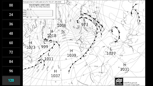
• UKMO analysis for +00 and forecasts for 12, 24, 36, 48, 60, 72, 84, 96 and 120 hours
• KNMI analysis for +00 and forecasts for 12, 24 and 36 hours
• isobars
• sea level pressure (hPa)
• frontal systems (heat and cold fronts and occlusions)
• thickness data (in UKMO B/W charts)
The charts are generated and generously made available by DWD, UKMO, KNMI and Wetterzentrale.de.
The maps have the purpose to merely supply you with large scale, longer term meteo info. To assess local actual conditions you will have to consult other sources.
To be able to download the charts in marginal internet connectivity conditions, the charts are supplied as low-resolution images, minimizing the file size.
Higher resolution images and zooming capability would suggest a reliability of the model outputs at a smaller scale. This has been discouraged by the meteorologists involved.
The app is light, fast and very easy to use. Morever it is free and without ads!
Features:
• DWD analysis for +00 and forecasts for 36, 48, 60, 84 and 108 hours
• UKMO analysis for +00 and forecasts for 12, 24, 36, 48, 60, 72, 84, 96 and 120 hours
• KNMI analysis for +00 and forecasts for 12, 24 and 36 hours
• isobars
• sea level pressure (hPa)
• frontal systems (heat and cold fronts and occlusions)
• thickness data (in UKMO B/W charts)
The charts are generated and generously made available by DWD, UKMO, KNMI and Wetterzentrale.de.
Aktualisiert am
Was die Sicherheit angeht, solltest du nachvollziehen, wie Entwickler deine Daten erheben und weitergeben. Die Datenschutz- und Sicherheitspraktiken können je nach Verwendung, Region und Alter des Nutzers variieren. Diese Informationen wurden vom Entwickler zur Verfügung gestellt und können jederzeit von ihm geändert werden.

Keine Daten werden mit Drittunternehmen oder -organisationen geteilt

Keine Daten erhoben


