Topographia Classic
Enthält Werbung
1 Tsg.+
Downloads

Jedes Alter
info

Über diese App
"Topographia Classic" is a suite of land surveying tools. It allows you to have complex surveying calculations on the field quickly with maximum accuracy. The design is as simple as needed under work pressure. The advantage is that can be used only with a simple total station or additionally with more complex instruments and gps.
Angular units : gradians (default) and decimal degrees (degrees only in Distance/Azimuth).
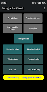
Task list:
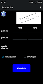
Parallel lines
Parallax distance
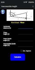
Inaccessible height
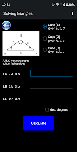
Triangles solution
Polygon Area
Line extension
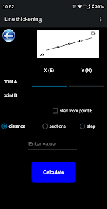
Line thickening
Trilateration
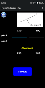
Perpendicular line
Arc information
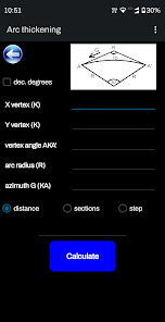
Arc thickening
Great tool for land surveyors, civil engineers, topographers and land engineers.
Download also our free application:
"Geodetic NET" from Google play
https://play.google.com/store/apps/details?id=com.GeodeticNET&hl=en
"Surveying In the Field" from Google play
https://play.google.com/store/apps/details?id=com.Surveying.IntheField&hl=en
"Topography On the Fly" from Google play
https://play.google.com/store/apps/details?id=com.TopOgraphy.OntheFly&hl=en&gl=US&pli=1
Don't forget to rate this app and send us a feedback.
Angular units : gradians (default) and decimal degrees (degrees only in Distance/Azimuth).
Task list:
Parallel lines
Parallax distance
Inaccessible height
Triangles solution
Polygon Area
Line extension
Line thickening
Trilateration
Perpendicular line
Arc information
Arc thickening
Great tool for land surveyors, civil engineers, topographers and land engineers.
Download also our free application:
"Geodetic NET" from Google play
https://play.google.com/store/apps/details?id=com.GeodeticNET&hl=en
"Surveying In the Field" from Google play
https://play.google.com/store/apps/details?id=com.Surveying.IntheField&hl=en
"Topography On the Fly" from Google play
https://play.google.com/store/apps/details?id=com.TopOgraphy.OntheFly&hl=en&gl=US&pli=1
Don't forget to rate this app and send us a feedback.
Aktualisiert am
Was die Sicherheit angeht, solltest du nachvollziehen, wie Entwickler deine Daten erheben und weitergeben. Die Datenschutz- und Sicherheitspraktiken können je nach Verwendung, Region und Alter des Nutzers variieren. Diese Informationen wurden vom Entwickler zur Verfügung gestellt und können jederzeit von ihm geändert werden.

Keine Daten werden mit Drittunternehmen oder -organisationen geteilt

Keine Daten erhoben

Daten werden bei der Übertragung verschlüsselt

Daten können nicht gelöscht werden


