OpenGround Data Collector
1 Tsg.+
Downloads

Jedes Alter
info
Über diese App
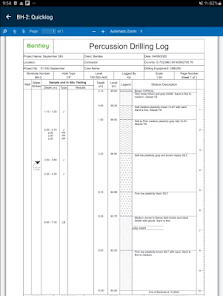
Designed for the Field: Intuitive touch-friendly interface designed for use by engineers and drillers throughout the ground investigation process. Typing and screen clicks are minimized via the use of autofocus, picklists, custom actions and configurable workflows. Coordinate multiple crews, provide rapid access to data from multiple locations and increase collaboration across both field and office-based teams.
Streamlined Data Synchronization: Simple data transfer enables data to be synchronized to the cloud in a matter of minutes, eliminating the need for complex data transfer mappings while also providing full support for offline working. Significantly reduce the time taken to transfer data back to the office to accelerate data analysis and report production. Make data informed decisions while field teams are still on site.
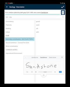
Customizable Data Entry Profiles: Only capture the required data by utilizing Mobile Data Entry Profiles optimized for specific data collection activities including Cable percussion, Trial pitting, Rotary coring, In-situ testing and Monitoring. A single field solution to meet both geotechnical and geo-environmental project requirements. Powerful expression-based calculated fields and default values help avoid data duplication and significantly reduce data entry time. Deploy data entry profiles into cloud-based configuration packs to enable standardization across multiple projects and distributed teams.
Powerful Data Validation: Avoid costly data errors or incomplete data capture. Configurable data quality checks and validation rules ensure high quality, standards compliant data collection at source. Significantly reduce data entry issues with customizable data warnings and critical checks.
Automated Label Printing: Streamline sample management in the field with built-in barcode generation and automated label printing via a ruggedized mobile printer.
GPS and Camera Integration: Quickly position exploratory locations using integrated GPS. Device-based camera integration provides automated photo linkage and synchronization including for locations, soil samples and core runs.
Streamlined Data Synchronization: Simple data transfer enables data to be synchronized to the cloud in a matter of minutes, eliminating the need for complex data transfer mappings while also providing full support for offline working. Significantly reduce the time taken to transfer data back to the office to accelerate data analysis and report production. Make data informed decisions while field teams are still on site.
Customizable Data Entry Profiles: Only capture the required data by utilizing Mobile Data Entry Profiles optimized for specific data collection activities including Cable percussion, Trial pitting, Rotary coring, In-situ testing and Monitoring. A single field solution to meet both geotechnical and geo-environmental project requirements. Powerful expression-based calculated fields and default values help avoid data duplication and significantly reduce data entry time. Deploy data entry profiles into cloud-based configuration packs to enable standardization across multiple projects and distributed teams.
Powerful Data Validation: Avoid costly data errors or incomplete data capture. Configurable data quality checks and validation rules ensure high quality, standards compliant data collection at source. Significantly reduce data entry issues with customizable data warnings and critical checks.
Automated Label Printing: Streamline sample management in the field with built-in barcode generation and automated label printing via a ruggedized mobile printer.
GPS and Camera Integration: Quickly position exploratory locations using integrated GPS. Device-based camera integration provides automated photo linkage and synchronization including for locations, soil samples and core runs.
Aktualisiert am
Was die Sicherheit angeht, solltest du nachvollziehen, wie Entwickler deine Daten erheben und weitergeben. Die Datenschutz- und Sicherheitspraktiken können je nach Verwendung, Region und Alter des Nutzers variieren. Diese Informationen wurden vom Entwickler zur Verfügung gestellt und können jederzeit von ihm geändert werden.

Keine Daten werden mit Drittunternehmen oder -organisationen geteilt

Diese App kann die folgenden Datentypen erheben
Standort

Daten werden bei der Übertragung verschlüsselt

Du kannst das Löschen der Daten beantragen
Neuigkeiten
Inform the user on the field when a data entry profile has changed and need to be refreshed on the tablet
Display more informative message when there's a licensing issue
Display more informative message when there's a licensing issue


