
Dynavix Navigation & Cameras
In-App-Käufe
3.7star
4.15 Tsg. Rezensionen
100 Tsg.+
Downloads

Jedes Alter
info
Über diese App
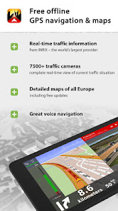
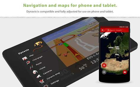
+ Free offline GPS navigation for Android + Android auto function.
+ Lifetime free map data updates several times a year. The maps are stored on your device, so they are available anytime, anywhere.
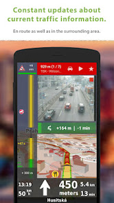
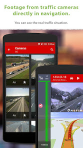
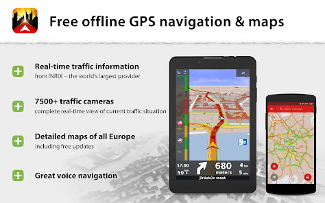
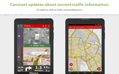
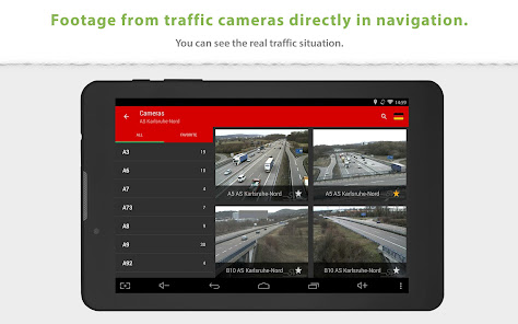
+ Route guidance using traffic cameras in real time.
______________________________________
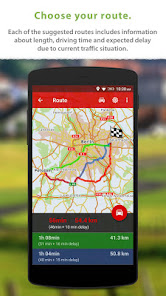
Snapshots from online traffic cameras near the planned route: Only Dynavix allows you to view data from traffic cameras located around the calculated route. In addition, Dynavix allows you to create custom lists of cameras, viewing data from cameras in the map, and other features. Dynavix currently supports access to over 7,500 traffic cameras across Europe.
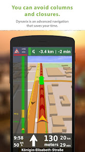
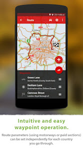
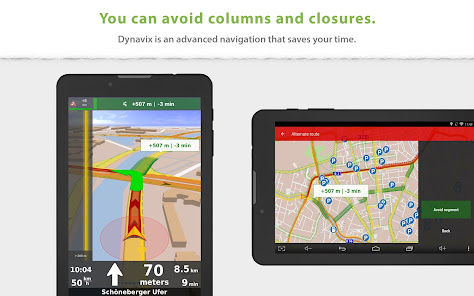
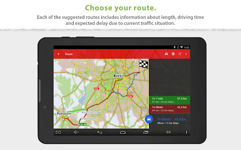
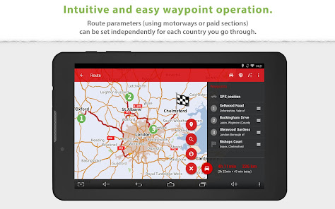
Advanced route planning using waypoints: The new Dynavix also significantly improves route planning with the use of waypoints. The planning is now very clear and adapted for use on mobile phones and tablets.
High-quality accurate maps: New Dynavix uses OpenStreetMap data. We believe the strength of the international community and current practice shows that OpenStreetMap are very detailed and often better than the maps from other providers.
The main functions of Dynavix:
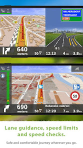
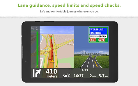
• Turn-by-turn offline voice navigation
• Views from online traffic cameras near the planned route
• Lifetime free map updates several times a year
• Android auto connectivity
• Advanced route planning using waypoints with the possibility of avoiding toll roads in certain countries or along the entire route
• Lane assistant and highway labels
• Full-text address search
• Alternative routes
• Support for voice commands via Bluetooth handsfree (Media mode or Phone call)
• Journey stats with possible export to *.csv
• Large database of points of interest
• 2D / 3D map view
• Speed check notification (with the possibility of importing community database radars)
• Speed limit warning
• Pedestrian navigation
• Wide range of view options personalization
Maps (stored in device memory):
Europe
Albania, Andorra, Belarus, Bosnia-Herzegovina, Bulgaria, Croatia, Czech Republic, Austria, Belgium, Denmark, Estonia, Finland, France, Germany, Gibraltar, Greece, Hungary, Italy, Ireland, Latvia, Liechtenstein, Lithuania, Luxembourg, Malta, Macedonia, Montenegro, Monaco, Netherlands, Norway, Slovakia, Slovenia, Spain, Poland Portugal, Romania, San Marino, Serbia, Sweden, Switzerland, Turkey, United Kingdom, Vatican City
Traffic information is available in the following countries:
Czech Republic, Belgium, Netherlands, Germany, Sweden, UK
North America
USA, Canada
______________________________________
For more information visit our website www.dynavix.com
If you like Dynavix navigation, we encourage you to write at least a short review.
Notes:
• Navigation can dramatically decrease battery life even running in the background. Make sure you keep the phone connected to the charger when using navigation.
• Real-time traffic information requires an internet connection.
+ Lifetime free map data updates several times a year. The maps are stored on your device, so they are available anytime, anywhere.
+ Route guidance using traffic cameras in real time.
______________________________________
Snapshots from online traffic cameras near the planned route: Only Dynavix allows you to view data from traffic cameras located around the calculated route. In addition, Dynavix allows you to create custom lists of cameras, viewing data from cameras in the map, and other features. Dynavix currently supports access to over 7,500 traffic cameras across Europe.
Advanced route planning using waypoints: The new Dynavix also significantly improves route planning with the use of waypoints. The planning is now very clear and adapted for use on mobile phones and tablets.
High-quality accurate maps: New Dynavix uses OpenStreetMap data. We believe the strength of the international community and current practice shows that OpenStreetMap are very detailed and often better than the maps from other providers.
The main functions of Dynavix:
• Turn-by-turn offline voice navigation
• Views from online traffic cameras near the planned route
• Lifetime free map updates several times a year
• Android auto connectivity
• Advanced route planning using waypoints with the possibility of avoiding toll roads in certain countries or along the entire route
• Lane assistant and highway labels
• Full-text address search
• Alternative routes
• Support for voice commands via Bluetooth handsfree (Media mode or Phone call)
• Journey stats with possible export to *.csv
• Large database of points of interest
• 2D / 3D map view
• Speed check notification (with the possibility of importing community database radars)
• Speed limit warning
• Pedestrian navigation
• Wide range of view options personalization
Maps (stored in device memory):
Europe
Albania, Andorra, Belarus, Bosnia-Herzegovina, Bulgaria, Croatia, Czech Republic, Austria, Belgium, Denmark, Estonia, Finland, France, Germany, Gibraltar, Greece, Hungary, Italy, Ireland, Latvia, Liechtenstein, Lithuania, Luxembourg, Malta, Macedonia, Montenegro, Monaco, Netherlands, Norway, Slovakia, Slovenia, Spain, Poland Portugal, Romania, San Marino, Serbia, Sweden, Switzerland, Turkey, United Kingdom, Vatican City
Traffic information is available in the following countries:
Czech Republic, Belgium, Netherlands, Germany, Sweden, UK
North America
USA, Canada
______________________________________
For more information visit our website www.dynavix.com
If you like Dynavix navigation, we encourage you to write at least a short review.
Notes:
• Navigation can dramatically decrease battery life even running in the background. Make sure you keep the phone connected to the charger when using navigation.
• Real-time traffic information requires an internet connection.
Aktualisiert am
Was die Sicherheit angeht, solltest du nachvollziehen, wie Entwickler deine Daten erheben und weitergeben. Die Datenschutz- und Sicherheitspraktiken können je nach Verwendung, Region und Alter des Nutzers variieren. Diese Informationen wurden vom Entwickler zur Verfügung gestellt und können jederzeit von ihm geändert werden.

Keine Daten werden mit Drittunternehmen oder -organisationen geteilt

Diese App kann die folgenden Datentypen erheben
Standort, Personenbezogene Daten und 4 andere

Daten werden bei der Übertragung verschlüsselt

Daten können nicht gelöscht werden
Bewertungen und Rezensionen
3.6
3.79 Tsg. Rezensionen
Neuigkeiten
+ Fixed broken UI after route calculation
+ Fixed incorrectly reported manoeuvres
+ Fixed button in Journey Records export
+ Simplified Find target - Address dialog
+ Fixed logging into fleet services
+ Corrections of map source data
+ Fixed incorrectly reported manoeuvres
+ Fixed button in Journey Records export
+ Simplified Find target - Address dialog
+ Fixed logging into fleet services
+ Corrections of map source data


