
notams.aero
In-App-Käufe
10 Tsg.+
Downloads

Jedes Alter
info


Über diese App
Notams Aero is the best NOTAM application.
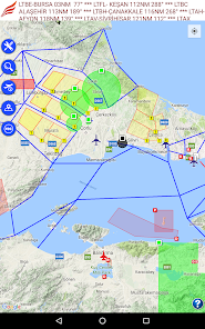
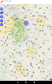
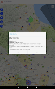
You can see NOTAMs on the map. Each NOTAM is displayed in categorized colors. Red means firing, yellow means training, blue means UAV, green means parachute etc. Additionally; each NOTAM area has a symbol which describes its subject ( for instance; you will see a remote control symbol for UAV NOTAM area)
* Flight recording and exporting of this as KML file
* Airport/Aerodrome meteorological information (METAR & TAF)
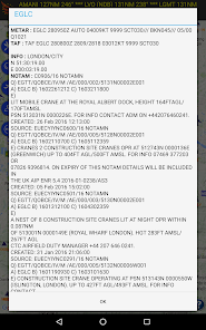
* Airport/Aerodrome NOTAMs
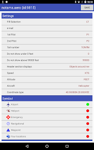
* Altitude filtering for NOTAMs
* All defined areas (prohibited areas, restricted areas, CTR, TMA etc)
* Airports, heliports and other aeronautical points with their detailed information
notams.aero contains these countries :
Albania, Armenia, Austria, Belgium, Bosnia, Bulgaria, Croatia, Cyprus, Czech Republic, Denmark, Estonia, Georgia, Germany, Greece, Finland, France, Hungary, Ireland, Italy, Latvia, Lithuania, Luxemburg, Macedonia, Malta, Moldova, Netherlands, Norway, Poland, Portugal, Romania, Serbia, Slovakia, Slovenia, Spain, Sweden, Switzerland, Ukraine, United Kingdom and United States
notams.aero is NOT FREE. You should purchase annual subscription to have all information.
For more information, privacy policy and terms of use please visit : http://notamtr.com/eu_policy.aspx
You can see NOTAMs on the map. Each NOTAM is displayed in categorized colors. Red means firing, yellow means training, blue means UAV, green means parachute etc. Additionally; each NOTAM area has a symbol which describes its subject ( for instance; you will see a remote control symbol for UAV NOTAM area)
* Flight recording and exporting of this as KML file
* Airport/Aerodrome meteorological information (METAR & TAF)
* Airport/Aerodrome NOTAMs
* Altitude filtering for NOTAMs
* All defined areas (prohibited areas, restricted areas, CTR, TMA etc)
* Airports, heliports and other aeronautical points with their detailed information
notams.aero contains these countries :
Albania, Armenia, Austria, Belgium, Bosnia, Bulgaria, Croatia, Cyprus, Czech Republic, Denmark, Estonia, Georgia, Germany, Greece, Finland, France, Hungary, Ireland, Italy, Latvia, Lithuania, Luxemburg, Macedonia, Malta, Moldova, Netherlands, Norway, Poland, Portugal, Romania, Serbia, Slovakia, Slovenia, Spain, Sweden, Switzerland, Ukraine, United Kingdom and United States
notams.aero is NOT FREE. You should purchase annual subscription to have all information.
For more information, privacy policy and terms of use please visit : http://notamtr.com/eu_policy.aspx
Aktualisiert am
Was die Sicherheit angeht, solltest du nachvollziehen, wie Entwickler deine Daten erheben und weitergeben. Die Datenschutz- und Sicherheitspraktiken können je nach Verwendung, Region und Alter des Nutzers variieren. Diese Informationen wurden vom Entwickler zur Verfügung gestellt und können jederzeit von ihm geändert werden.

Keine Daten werden mit Drittunternehmen oder -organisationen geteilt

Keine Daten erhoben

Daten werden nicht verschlüsselt

Du kannst das Löschen der Daten beantragen
Neuigkeiten
New notam types added
Support für diese App
phone
Telefonnummer
+905333528158


