
CartoDruid - GIS offline tool

4.8star
202 Rezensionen
10 Tsg.+
Downloads

Jedes Alter
info


Über diese App
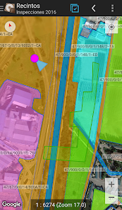
CartoDruid is a GIS application developed by the Instituto Tecnológico Agrario de Castilla y León (ITACyL), designed as a tool to support fieldwork. It addresses the challenge of offline editing of georeferenced information.
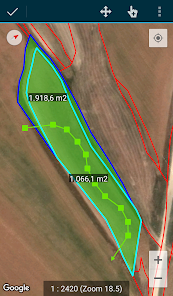
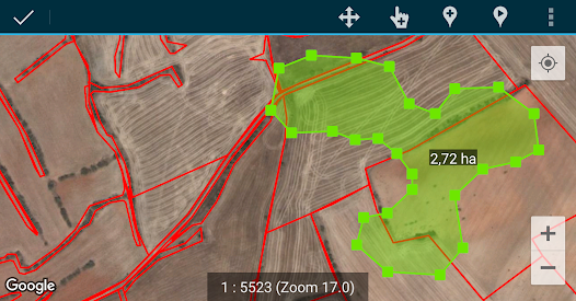
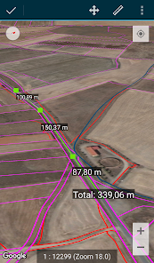
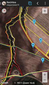
In many field areas with insufficient mobile coverage, CartoDruid provides a reliable solution by enabling visualization of raster and vectorial layers stored on the device. It allows the creation of new geometries (entities) by drawing them directly on the screen or using embedded or external GPS.
CartoDruid is user-friendly and doesn’t require previous GIS knowledge, making it easy to configure and use for anyone managing fieldwork information. Data generated can be exported for use in external applications.
Features of CartoDruid include:
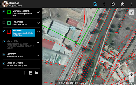
Visualization of online Google Maps.
Usage of vectorial cartography in a SpatiaLite database.
Raster imagery support from a RasterLite database.
Online WMS services consumption.
Creation and configuration of new layers on the device.
Filtering, symbologies, labeling, searching, and identification forms based on SQL queries.
Editing attributes and manual drawing of geometries.
GPS-based drawing and editing of geometries.
Advanced geometry editing tools.
Data saving features, including georeferenced data and associating pictures to entities.
Additional tools like SIGPAC search, measurement tools, navigation aids, bookmarks management.
Import and export functionalities in multiple formats.
TOC management and SHP file support as an experimental feature.
Layer operation controls.
CartoDruid uses background location services for creating features based on location tracking. User location is only used for creating geometry vertices or map positioning, with data stored locally and not sent outside the device. Project folder deletion allows for easy data removal.
For a complete list of features, downloadable examples, and starting guides, visit www.cartodruid.es.
In many field areas with insufficient mobile coverage, CartoDruid provides a reliable solution by enabling visualization of raster and vectorial layers stored on the device. It allows the creation of new geometries (entities) by drawing them directly on the screen or using embedded or external GPS.
CartoDruid is user-friendly and doesn’t require previous GIS knowledge, making it easy to configure and use for anyone managing fieldwork information. Data generated can be exported for use in external applications.
Features of CartoDruid include:
Visualization of online Google Maps.
Usage of vectorial cartography in a SpatiaLite database.
Raster imagery support from a RasterLite database.
Online WMS services consumption.
Creation and configuration of new layers on the device.
Filtering, symbologies, labeling, searching, and identification forms based on SQL queries.
Editing attributes and manual drawing of geometries.
GPS-based drawing and editing of geometries.
Advanced geometry editing tools.
Data saving features, including georeferenced data and associating pictures to entities.
Additional tools like SIGPAC search, measurement tools, navigation aids, bookmarks management.
Import and export functionalities in multiple formats.
TOC management and SHP file support as an experimental feature.
Layer operation controls.
CartoDruid uses background location services for creating features based on location tracking. User location is only used for creating geometry vertices or map positioning, with data stored locally and not sent outside the device. Project folder deletion allows for easy data removal.
For a complete list of features, downloadable examples, and starting guides, visit www.cartodruid.es.
Aktualisiert am
Was die Sicherheit angeht, solltest du nachvollziehen, wie Entwickler deine Daten erheben und weitergeben. Die Datenschutz- und Sicherheitspraktiken können je nach Verwendung, Region und Alter des Nutzers variieren. Diese Informationen wurden vom Entwickler zur Verfügung gestellt und können jederzeit von ihm geändert werden.

Keine Daten werden mit Drittunternehmen oder -organisationen geteilt

Keine Daten erhoben
Bewertungen und Rezensionen
4.8
177 Rezensionen