
SAFires
1 હજાર+
ડાઉનલોડ

પ્રત્યેક
info
આ ઍપનું વર્ણન
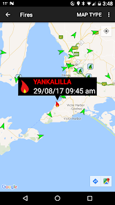
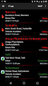
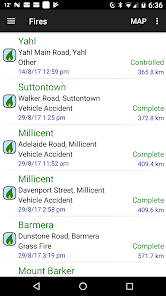
This application is designed to provide up to date information about bush fire data in the state of South Australia, Australia for users of Android devices.
It utilises data from the South Australia Country Fire Service data feeds on fires with your current location provided by the phone GPS.
Using this information the application is able to provide a list of fires showing the nearest ones first, helping you to understand your current situation.
The information is reliant on both the accuracy of the phone's GPS and the data recorded on the CFS's website.
This application does not cache any data, so Internet access (either Wireless. or 3G) is required to access the data.
Be aware that while P4G has utilised "best efforts" to provide this information to you, it is not intended to replace other sources of information on the fire situation near you. Also remember that fire and weather can change quickly.
Follow P4G on twitter at P4G_Apps
આ રોજ અપડેટ કર્યું
ડેવલપર તમારો ડેટા કેવી રીતે એકત્રિત અને શેર કરે છે, તે સમજવાથી સુરક્ષાની શરૂઆત થાય છે. તમારા દ્વારા ઍપનો ઉપયોગ, ઉપયોગ થાય તે પ્રદેશ અને તમારી ઉંમરના આધારે ડેટાની પ્રાઇવસી અને સુરક્ષા પદ્ધતિઓ અલગ-અલગ હોઈ શકે છે. ડેવલપર દ્વારા આ માહિતી પ્રદાન કરવામાં આવી છે અને તેઓ સમયાંતરે તેને અપડેટ કરી શકે છે.


નવું શું છે?
Fixes bug where map does not load - Please install!


