mKart Marine Navigation
Achats via l'appli
3,5star
120 avis
10K+
Téléchargements

Tout public
info


À propos de l'application
mKart is easy to install and use online marine navigation software (from creators of ECS/ECDIS dKart Navigator) with the fastest chart engine using hybrid ON/OFF sea maps concept and 3D nautical charts.
Product Highlights:
WEB CONSOLE:
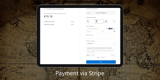
E-shop;
ENCs and cartographic products Catalogue;
Portfolio optimization;
Fleet management;
Roots and tracks;
Data exchange;
Accounting;
SAFETY IS IN FOCUS:
Automatic routing and NO-GO Area display;
Dangerous depths and objects automatic control.
Safe sailing alternative and recommendations;
Meeting points and hazardous traverses calculations.
Background monitoring: dangers’ and ships’ alerts, all along the route.
Apple watch support.
DOCKING:
Click on the chart, select the location and follow the docking path.
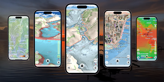
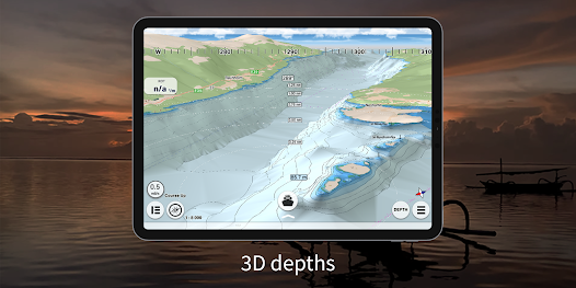
3D MARINE AND OSM CHARTS:
3D marine and OSM charts are uploaded and displayed automatically. 3D sea floor, land’s relief, 3D buildings, ships and infrastructure models contribute to better seafarers orientation and awareness.
FREE NOAA ENCs:
Online NOAA nautical charts are being installed automatically via Internet by customer’s position or while browsing and stored for off-line use. Updating is performed in the same way.
SMART PANELS:
Swipe from below and from side to side. Profiles of seabed relief, safety path simulator, docking.
MARINE ROUTE PLANNER:
Save time with integrated sea and river auto routes functionality. Safety checks is implemented along with route monitoring functionality and warning system.
NO GO ZONE:
Display safety area is filled up graphically on the sea map by only safe depth. Safety zone is calculated trough 3D sea bottom model.
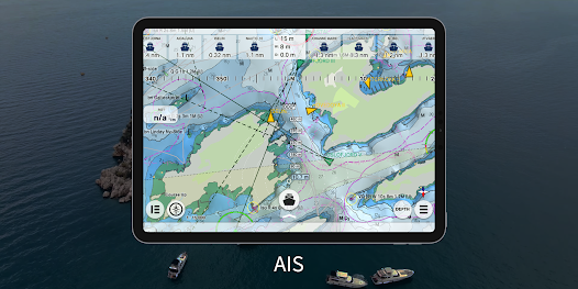
MARINE TRAFFIC:
Marine traffic data can be obtained from open AIS streams over Internet to display and identify dangerous targets.
COMPASS MODE:
Get a quick look around while boat navigation with advanced VR option for better orientation and using visual aids for navigation effectively.
SEARCH:
Search all objects and information on ENC S-57 charts trough SW and data via universal search function.
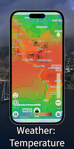
MARINE WEATHER:
mKart online services allows to deliver highly detailed weather information and forecast.
TRACKS AND WAYPOINTS:
PLT and WPT import and export, recording and displaying on the chart.
Product Highlights:
WEB CONSOLE:
E-shop;
ENCs and cartographic products Catalogue;
Portfolio optimization;
Fleet management;
Roots and tracks;
Data exchange;
Accounting;
SAFETY IS IN FOCUS:
Automatic routing and NO-GO Area display;
Dangerous depths and objects automatic control.
Safe sailing alternative and recommendations;
Meeting points and hazardous traverses calculations.
Background monitoring: dangers’ and ships’ alerts, all along the route.
Apple watch support.
DOCKING:
Click on the chart, select the location and follow the docking path.
3D MARINE AND OSM CHARTS:
3D marine and OSM charts are uploaded and displayed automatically. 3D sea floor, land’s relief, 3D buildings, ships and infrastructure models contribute to better seafarers orientation and awareness.
FREE NOAA ENCs:
Online NOAA nautical charts are being installed automatically via Internet by customer’s position or while browsing and stored for off-line use. Updating is performed in the same way.
SMART PANELS:
Swipe from below and from side to side. Profiles of seabed relief, safety path simulator, docking.
MARINE ROUTE PLANNER:
Save time with integrated sea and river auto routes functionality. Safety checks is implemented along with route monitoring functionality and warning system.
NO GO ZONE:
Display safety area is filled up graphically on the sea map by only safe depth. Safety zone is calculated trough 3D sea bottom model.
MARINE TRAFFIC:
Marine traffic data can be obtained from open AIS streams over Internet to display and identify dangerous targets.
COMPASS MODE:
Get a quick look around while boat navigation with advanced VR option for better orientation and using visual aids for navigation effectively.
SEARCH:
Search all objects and information on ENC S-57 charts trough SW and data via universal search function.
MARINE WEATHER:
mKart online services allows to deliver highly detailed weather information and forecast.
TRACKS AND WAYPOINTS:
PLT and WPT import and export, recording and displaying on the chart.
Date de mise à jour
La sécurité, c'est d'abord comprendre comment les développeurs collectent et partagent vos données. Les pratiques concernant leur confidentialité et leur protection peuvent varier selon votre utilisation, votre région et votre âge. Le développeur a fourni ces informations et peut les modifier ultérieurement.

Aucune donnée partagée avec des tiers
En savoir plus sur la manière dont les développeurs déclarent le partage

Cette appli peut recueillir ces types de données
Position, Informations personnelles et 2 autres

Les données ne sont pas chiffrées

Vous pouvez demander la suppression des données
Notes et avis
3,4
113 avis
Nouveautés
We have added the ability to purchase an ENC via the GetENC service to the app. Now buying a PRIMAR charts has become even faster and easier.


