LunarMap HD
4,3star
214 komente
10 mijë+
shkarkime

Të gjithë
info


Rreth këtij aplikacioni
Moon maps galore! Scroll, zoom and search through high resolution US Geological Survey and NASA maps. LunarMap HD is fun for anybody who wants to see and know more about earth's lovely satellite and is a great companion for amateur astronomy observations through a telescope.
Features of LunarMap HD include
- Nearside and farside of the moon
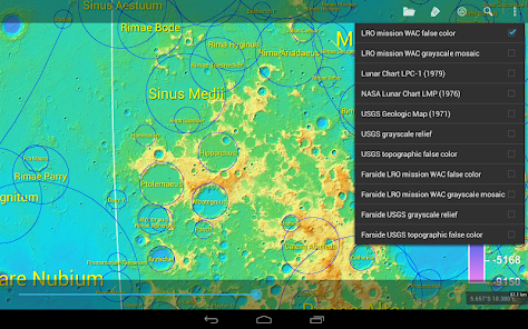
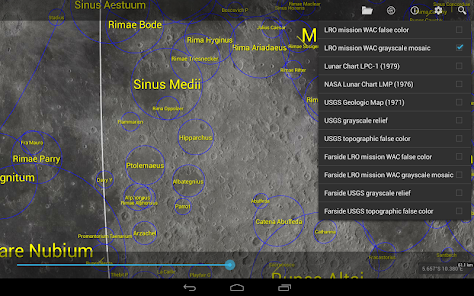
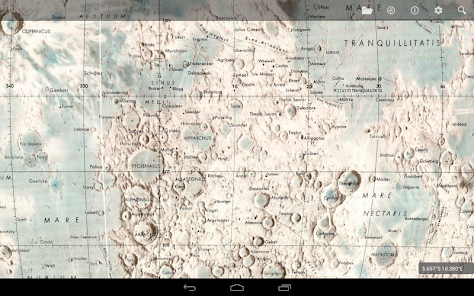
- Realistic US Geological Survey relief map (5120x5120 resolution)
- Beautiful photographic maps from the Lunar Reconnaissance Orbiter's Wide Angle Camera (20480x20480)
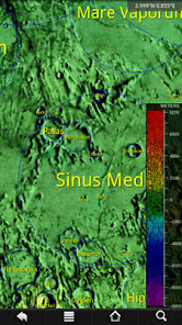
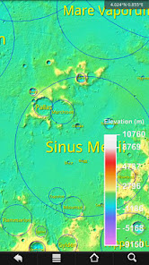
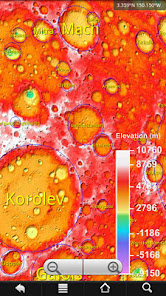
- Color-coded topological maps from both the USGS and NASA
- Realtime terminator (shadow) line
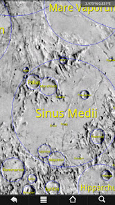
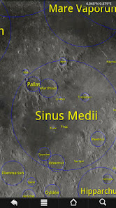
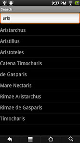
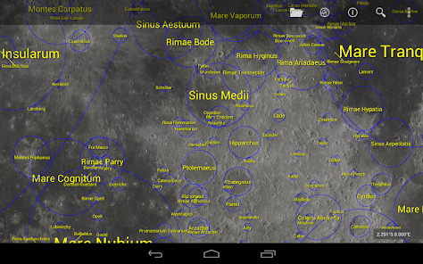
- Searchable labels for over 8950 craters, maria, mountains, valleys, Apollo landing sites and more, based on International Astronomical Union data; tap on feature for more information or to lookup in Wikipedia
- Rotate and/or flip the map to match your telescope's eyepiece view, or for users in the southern hemisphere
- Zoom with two fingers (multitouch devices only), on-screen buttons or volume keys
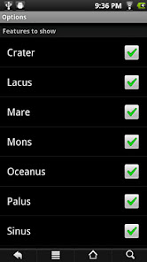
- Customize colors, labels shown and other features
- Optionally lock screen rotation or make it harder to change so you need to turn the device further than usual to rotate to prevent accidental screen rotations while observing
- The maps are 2D. The nearside maps are projected to show a small portion of the farside, since libration can reveal a small portion of the farside
Note: To save app download time, maps other than the USGS relief nearside map involve an additional free in-app download, hence the Internet permission.
Features of LunarMap HD include
- Nearside and farside of the moon
- Realistic US Geological Survey relief map (5120x5120 resolution)
- Beautiful photographic maps from the Lunar Reconnaissance Orbiter's Wide Angle Camera (20480x20480)
- Color-coded topological maps from both the USGS and NASA
- Realtime terminator (shadow) line
- Searchable labels for over 8950 craters, maria, mountains, valleys, Apollo landing sites and more, based on International Astronomical Union data; tap on feature for more information or to lookup in Wikipedia
- Rotate and/or flip the map to match your telescope's eyepiece view, or for users in the southern hemisphere
- Zoom with two fingers (multitouch devices only), on-screen buttons or volume keys
- Customize colors, labels shown and other features
- Optionally lock screen rotation or make it harder to change so you need to turn the device further than usual to rotate to prevent accidental screen rotations while observing
- The maps are 2D. The nearside maps are projected to show a small portion of the farside, since libration can reveal a small portion of the farside
Note: To save app download time, maps other than the USGS relief nearside map involve an additional free in-app download, hence the Internet permission.
Përditësuar më
Siguria fillon me njohjen e mënyrës se si i mbledhin dhe i ndajnë zhvilluesit të dhënat e tua. Praktikat për privatësinë dhe sigurinë e të dhënave mund të variojnë bazuar në përdorimin, rajonin dhe moshën tënde. Këto informacione janë dhënë nga zhvilluesi dhe ato mund të përditësohen me kalimin e kohës.

Nuk ndahen të dhëna me palë të treta
Mëso më shumë për mënyrën se si e deklarojnë zhvilluesit ndarjen e të dhënave

Nuk mblidhen të dhëna
Mëso më shumë për mënyrën se si e deklarojnë zhvilluesit mbledhjen e të dhënave
Vlerësime dhe komente
4,2
164 komente
Ç'të reja ka
1.45: Update for newer devices
1.21: Add some missing labels
1.20: Optimization
1.14: NASA Lunar Chart LMP; minor bug fixes and optimizations
1.13: Nearside USGS Geologic Map (1971)
1.12: option to turn off zoom buttons; fix terminator code
1.11: Fix memory handling; astronaut-named features
1.10: Add 7000+ satellite features
1.21: Add some missing labels
1.20: Optimization
1.14: NASA Lunar Chart LMP; minor bug fixes and optimizations
1.13: Nearside USGS Geologic Map (1971)
1.12: option to turn off zoom buttons; fix terminator code
1.11: Fix memory handling; astronaut-named features
1.10: Add 7000+ satellite features


