In Sight - New Zealand+

+5
ڈاؤن لوڈز

ہر کوئی
info
اس ایپ کے بارے میں
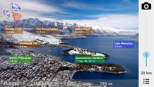
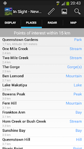
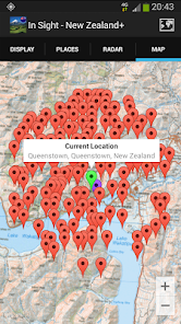
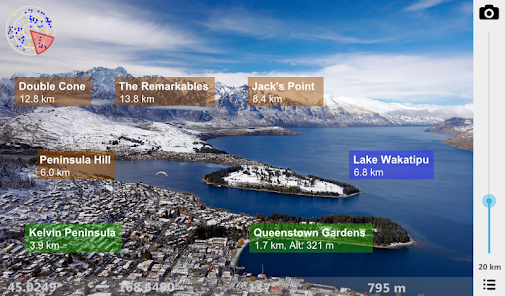
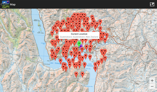
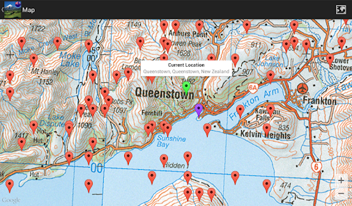
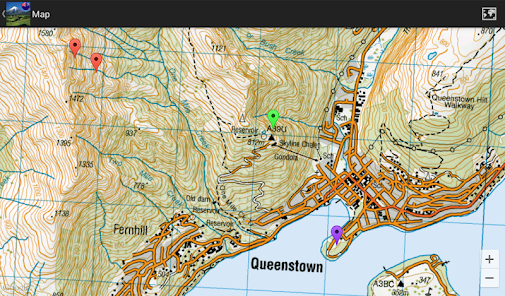
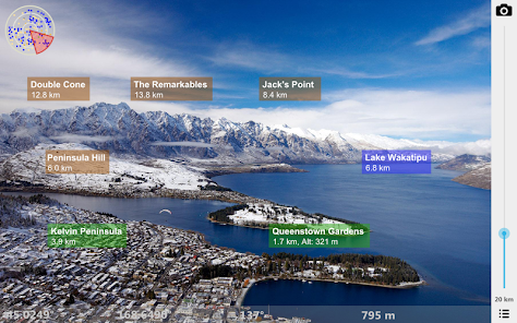
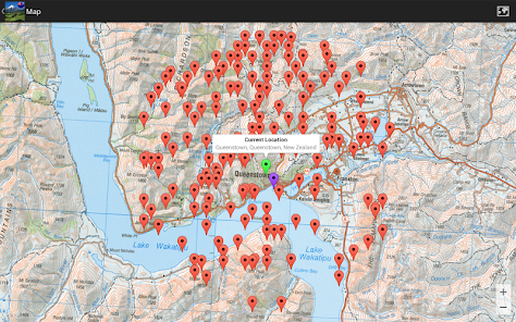
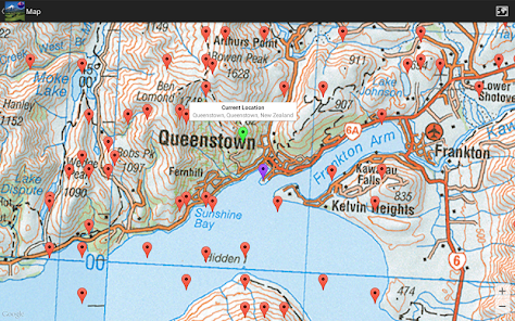
What is the name of the mountain you can see in the distance? What are the lakes you see in front of you? Point there with In Sight New Zealand+ and you'll see on the screen what they are called. See also places nearby with amazing high-resolution maps. High resolution offline maps of New Zealand are used down to a scale of 1:50 000.
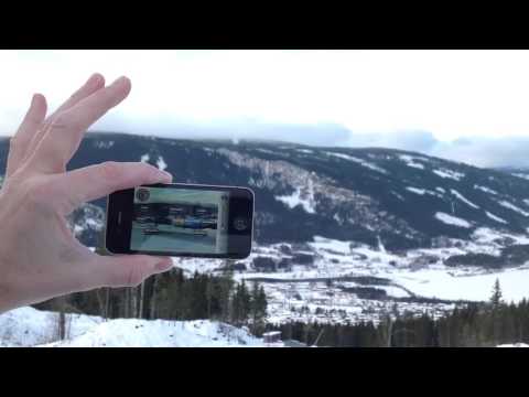
Offline Augmented Reality in New Zealand.
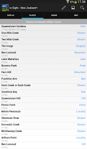
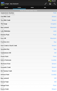
See what's near you where you travel in New Zealand: Mountains, Lakes, Places, Buildings, etc. You don't even have to be nearby New Zealand: You can manually set your location to a place in New Zealand to pretend you are there. Decide if you want to see places nearby, or famous cities around the world.
Works everywhere: By the sea, in the mountains, in the city. Without the internet, without coverage.
Turn the phone sideways to view on the camera screen the places that are nearby. Take a picture of what you see, and send it by email, or post it on facebook, directly from the App!
You can also add your own places!
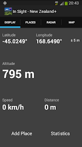
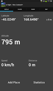
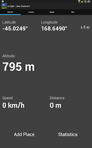
In Sight New Zealand+ is also an altimeter, speedometer and also estimates the distance you've traveled. Choose between metric (km, meter) or imperial (miles, feet) units.
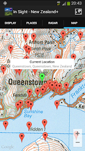
All data is built into the App, so you don't need internet. You only need internet when you use the map or send a picture on email or post it on facebook. High-resolution maps down to a scale of 1:50 000 don’t require internet. For finer resolution internet is used.
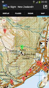
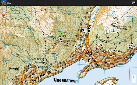
Select between the following map types: Standard, Satellite, Hybrid, and High Resolution. High resolution maps are provided by New Zealand Topographic Maps (www.nztopomaps.com).
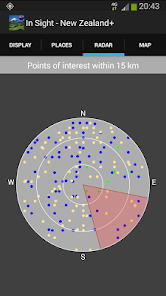
In Sight New Zealand+ relies on the compass and GPS of your device. Best results are achieved if you are outside.
COMPASS CALIBRATION AND ACCURACY.
One way to calibrate the compass is to move the phone in an 8-number manner 3 times: Once when the phone is in landscape, once in portrait and once facing up. Also stay away from magnetic sources that might influence the compass. For the compass to be accurate under usage, you have to be outside to get a good location reading.
Source: ws.geonames.org under the Creative Commons Attribution 3.0 License (http://creativecommons.org/licenses/by/3.0/)
High resolution maps from New Zealand Topographic Maps (www.nztopomaps.com) are sourced from Land Information New Zealand and are licensed under the Creative Commons Attribution 3.0 New Zealand license (CC BY 3.0 NZ) (http://creativecommons.org/licenses/by/3.0/nz)
Offline Augmented Reality in New Zealand.
See what's near you where you travel in New Zealand: Mountains, Lakes, Places, Buildings, etc. You don't even have to be nearby New Zealand: You can manually set your location to a place in New Zealand to pretend you are there. Decide if you want to see places nearby, or famous cities around the world.
Works everywhere: By the sea, in the mountains, in the city. Without the internet, without coverage.
Turn the phone sideways to view on the camera screen the places that are nearby. Take a picture of what you see, and send it by email, or post it on facebook, directly from the App!
You can also add your own places!
In Sight New Zealand+ is also an altimeter, speedometer and also estimates the distance you've traveled. Choose between metric (km, meter) or imperial (miles, feet) units.
All data is built into the App, so you don't need internet. You only need internet when you use the map or send a picture on email or post it on facebook. High-resolution maps down to a scale of 1:50 000 don’t require internet. For finer resolution internet is used.
Select between the following map types: Standard, Satellite, Hybrid, and High Resolution. High resolution maps are provided by New Zealand Topographic Maps (www.nztopomaps.com).
In Sight New Zealand+ relies on the compass and GPS of your device. Best results are achieved if you are outside.
COMPASS CALIBRATION AND ACCURACY.
One way to calibrate the compass is to move the phone in an 8-number manner 3 times: Once when the phone is in landscape, once in portrait and once facing up. Also stay away from magnetic sources that might influence the compass. For the compass to be accurate under usage, you have to be outside to get a good location reading.
Source: ws.geonames.org under the Creative Commons Attribution 3.0 License (http://creativecommons.org/licenses/by/3.0/)
High resolution maps from New Zealand Topographic Maps (www.nztopomaps.com) are sourced from Land Information New Zealand and are licensed under the Creative Commons Attribution 3.0 New Zealand license (CC BY 3.0 NZ) (http://creativecommons.org/licenses/by/3.0/nz)
اپ ڈیٹ کردہ بتاریخ
سیفٹی اس بات کو سمجھنے کے ساتھ شروع ہوتی ہے کہ ڈویلپرز آپ کا ڈیٹا کیسے اکٹھا اور اس کا اشتراک کرتے ہیں۔ ڈیٹا کی رازداری اور سیکیورٹی کے طریقے آپ کے استعمال، علاقے اور عمر کی بنیاد پر مختلف ہو سکتے ہیں۔ ڈویلپر نے یہ معلومات فراہم کی ہے اور وقت کے ساتھ ساتھ اسے اپ ڈیٹ کر سکتا ہے۔

فریقین ثالث کے ساتھ کسی بھی ڈیٹا کا اشتراک نہیں کیا گیا
ڈویلپرز کے اشتراک کے اعلان کے بارے میں مزید جانیں

کوئی ڈیٹا اکٹھا نہیں کیا گیا
ڈویلپرز کے اکٹھا کرنے کے اعلان کے طریقے بارے میں مزید جانیں

ڈیٹا مرموز کردہ نہیں ہے
ڈیٹا حذف نہیں کیا جا سکتا
نیا کیا ہے
Support for Android 9.
Bug fixes.
Bug fixes.


