
RunwayMap: Aviation Weather
Ilova ichida xaridlar
3,8star
179 ta sharh
10 ming+
Yuklanmalar

Hamma uchun
info


Bu ilova haqida
RunwayMap is the #1 pilot community all about the passion of flying. You can view flight videos, reviews and photos from other pilots as well as share your flying experiences.
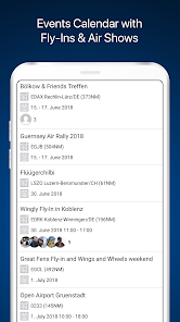
Need some ideas for your next day trip? The RunwayMap events calendar shows you events like airport festivals, fly-ins, and vintage plane shows.
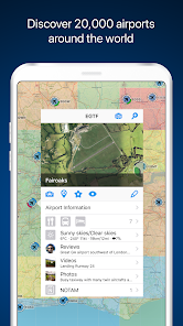
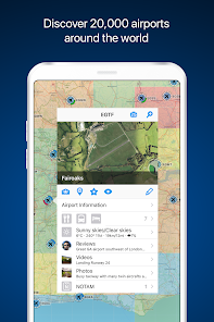
The interactive map gives you an overview of the airports. We have collected important information on every airport:
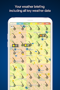
• Aviation weather forecasts
• Runways & NOTAM
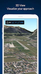
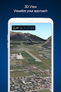
• 3D and satellite views
• Webcams and much more
RunwayMap simplifies flight preparation and complements flight planning tools such as SkyDemon, Jeppesen and Garmin Pilot.
Download the versatile pilot app while you are at it.
Features:
MAP
Search by name or ICAO to discover new airports. Receive important information such as the current weather, address, position, runways, NOTAM and sunrise/sunset. Mark and save what airports you’ve already flown to or those you’d like to fly to next. Save your personal notes for every airport.
EVENTS CALENDAR
The RunwayMap events calendar shows you events like airport festivals, fly-ins, and vintage plane shows. Each event displays the distance from your home base to the event location in nautical miles, as well as which pilots from the RunwayMap community are also interested in going.
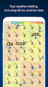
AVIATION WEATHER
Current weather reports, visual flight conditions und wind forecasts are shown on our map.
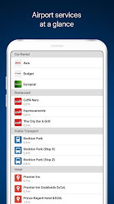
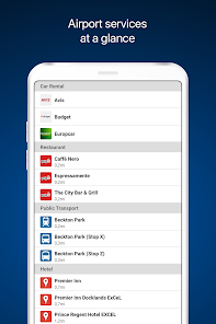
ON-SITE SERVICES
Discover restaurants and hotels near the airport. Get informed about public transport and car rental offers.
3D AND SATELLITE VIEWS
Check out the airport environment in 3D and satellite views. Use the OpenStreetMap view for detailed vehicle access information.
DOCUMENTS
With just a few clicks, add your flight documents, such as the Jeppesen approach charts, FAA terminal procedures and airport diagrams, SkyDemon manuals or the Garmin pilot’s guide. That way you always have them close at hand.
TOOLS
Use the handy calculator for conversions for distance, weight, temperature, and more. Have it display your QNH and QFE.
RUNWAYMAP APP
Important note: RunwayMap is not intended to provide aeronautical information or navigation aids. For navigation purposes, we strongly recommend using only approved and updated aviation information such as SkyDemon, Jeppesen or Garmin Pilot.
The weather data shown in RunwayMap is only general information about possible weather development. It does not replace professional weather briefing by an official body before the flight.
Learn more about RunwayMap at runwaymap.com
Need some ideas for your next day trip? The RunwayMap events calendar shows you events like airport festivals, fly-ins, and vintage plane shows.
The interactive map gives you an overview of the airports. We have collected important information on every airport:
• Aviation weather forecasts
• Runways & NOTAM
• 3D and satellite views
• Webcams and much more
RunwayMap simplifies flight preparation and complements flight planning tools such as SkyDemon, Jeppesen and Garmin Pilot.
Download the versatile pilot app while you are at it.
Features:
MAP
Search by name or ICAO to discover new airports. Receive important information such as the current weather, address, position, runways, NOTAM and sunrise/sunset. Mark and save what airports you’ve already flown to or those you’d like to fly to next. Save your personal notes for every airport.
EVENTS CALENDAR
The RunwayMap events calendar shows you events like airport festivals, fly-ins, and vintage plane shows. Each event displays the distance from your home base to the event location in nautical miles, as well as which pilots from the RunwayMap community are also interested in going.
AVIATION WEATHER
Current weather reports, visual flight conditions und wind forecasts are shown on our map.
ON-SITE SERVICES
Discover restaurants and hotels near the airport. Get informed about public transport and car rental offers.
3D AND SATELLITE VIEWS
Check out the airport environment in 3D and satellite views. Use the OpenStreetMap view for detailed vehicle access information.
DOCUMENTS
With just a few clicks, add your flight documents, such as the Jeppesen approach charts, FAA terminal procedures and airport diagrams, SkyDemon manuals or the Garmin pilot’s guide. That way you always have them close at hand.
TOOLS
Use the handy calculator for conversions for distance, weight, temperature, and more. Have it display your QNH and QFE.
RUNWAYMAP APP
Important note: RunwayMap is not intended to provide aeronautical information or navigation aids. For navigation purposes, we strongly recommend using only approved and updated aviation information such as SkyDemon, Jeppesen or Garmin Pilot.
The weather data shown in RunwayMap is only general information about possible weather development. It does not replace professional weather briefing by an official body before the flight.
Learn more about RunwayMap at runwaymap.com
Oxirgi yangilanish
Xavfsizlik — dastur ishlab chiquvchilar maʼlumotlaringizni qanday jamlashi va ulashishini tushinishdan boshlanadi. Maʼlumotlar maxfiyligi va xavfsizlik amaliyotlari ilovadan foydalanish, hudud va yoshga qarab farq qilishi mumkin. Bu axborot dastur ishlab chiquvchi tomonidan taqdim etilgan va keyinchalik yangilanishi mumkin.

Tashqi hamkorlarga hech qanday axborot ulashilmagan
Dastur ishlab chiquvchilar axborot ulashilishini qanday aytishi haqida batafsil

Ushbu ilova quyidagi axborot turlarini toʻplashi mumkin
Men haqimda, Ilova tarixi va Qurilma yoki boshqa identifikatorlar

Maʼlumotlar uzatish vaqtida shifrlanadi

Maʼlumotlarni oʻchirishni soʻrashingiz mumkin
Reytinglar va sharhlar
4,0
148 ta sharh
Nima yangiliklar
In this release we have done some updates and bug fixes. We are happy to receive suggestions, send us an email to support@runwaymap.com.