
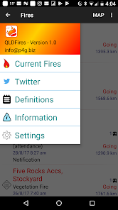
QLDFires
10 ming+
Yuklanmalar

Hamma uchun
info
Bu ilova haqida
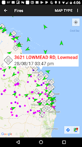
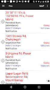
This application is designed to provide up to date information about bush fire data in Queensland, Australia for users of Android devices.
It utilises data from the Queensland Rural Fire Service data feeds on fires with your current location provided by the phone GPS.
Using this information the application is able to provide a list of fires showing the nearest ones first, helping you to understand your current situation.
The information is reliant on both the accuracy of the phone's GPS and the data recorded on the QFES's website. Please note however that this application does not represent in any way the Queensland Government.
This application does not cache any data, so Internet access (either Wireless. or 3G) is required to access the data.
Be aware that while P4G has utilised "best efforts" to provide this information to you, it is not intended to replace other sources of information on the fire situation near you. Also remember that fire and weather can change quickly.
Follow P4G on twitter at P4G_Apps
Oxirgi yangilanish
Xavfsizlik — dastur ishlab chiquvchilar maʼlumotlaringizni qanday jamlashi va ulashishini tushinishdan boshlanadi. Maʼlumotlar maxfiyligi va xavfsizlik amaliyotlari ilovadan foydalanish, hudud va yoshga qarab farq qilishi mumkin. Bu axborot dastur ishlab chiquvchi tomonidan taqdim etilgan va keyinchalik yangilanishi mumkin.

Tashqi hamkorlarga hech qanday axborot ulashilmagan
Dastur ishlab chiquvchilar axborot ulashilishini qanday aytishi haqida batafsil

Hech qanday maʼlumot jamlanmagan
Dastur ishlab chiquvchilar axborot jamlanishini qanday aytishi haqida batafsil

Maʼlumotlar uzatish vaqtida shifrlanadi

Maʼlumotlar oʻchmaydi
Nima yangiliklar
We have made some optimisation changes to the way satellite data is shown and hope this fixes a number of performance issues, crashes and/or hangs in the map.


