PRO CHARTS - Marine Navigation
Ilova ichida xaridlar
2,6star
21 ta sharh
1 ming+
Yuklanmalar

Hamma uchun
info
Bu ilova haqida
MiraTrex PRO CHARTS™ is a powerful, yet easy-to-use marine navigation solution. PRO CHARTS™ includes high resolution NOAA charts and other nautical maps not included with a traditional chartplotter. Whether you’re a fisherman, weekend cruiser, sailor, jet-skier, or an offshore captain needing to find an exact location hundreds of miles offshore, PRO CHARTS™ will get you there and back home safely.
The free evaluation version displays standard satellite, road, and hybrid maps. An in-app subscription purchase of $2.99/mo or $29.99/yr includes nautical charts, navigational features, and frequent app upgrades.
Key Features:
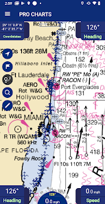
• High-resolution nautical chart coverage for all U.S. coastal areas, the Great Lakes, major U.S. river systems, and Brazil plus global high-level nautical charts. Charts are automatically updated every 7 days based on NOAA chart corrections.
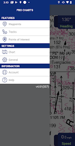
• Easy one-touch Waypoint and Route creation. Pre-plan your routes at home or create them at sea with equal ease. Just touch the screen to create new waypoints and routes.
• Find your friends on the water. With our new Buddy-tracking feature, you can see and meet up with your friends while you’re out on the water. If you’re on your secret spot and don’t want to be seen, you can hide your location with the touch of a button.
• Stay safe. Easily create and send a Float Plan of your trip to a friend or family member. Your Float Plan and location history can be forwarded to search and rescue personnel in case of an emergency.
• Easy point-and-steer navigation. The red heading bug on the large on-screen compass always directs you to the next point on your route. Navigation is as easy as pointing your boat at the heading bug to stay on course.
• No Network. No Problem. PRO CHARTS™ is designed so no internet connection is required to view your charts while out on the water. You simply download in advance any charts you’ll need at sea with the touch of a button.
• Record your tracks. Track your position in real-time and later view your track history.
• Fully indexed point of interest (POI) database including weather, aids to navigation (markers and lights), obstructions, tides, currents, your buddies, and more.
Website: www.miratrex.com
The free evaluation version displays standard satellite, road, and hybrid maps. An in-app subscription purchase of $2.99/mo or $29.99/yr includes nautical charts, navigational features, and frequent app upgrades.
Key Features:
• High-resolution nautical chart coverage for all U.S. coastal areas, the Great Lakes, major U.S. river systems, and Brazil plus global high-level nautical charts. Charts are automatically updated every 7 days based on NOAA chart corrections.
• Easy one-touch Waypoint and Route creation. Pre-plan your routes at home or create them at sea with equal ease. Just touch the screen to create new waypoints and routes.
• Find your friends on the water. With our new Buddy-tracking feature, you can see and meet up with your friends while you’re out on the water. If you’re on your secret spot and don’t want to be seen, you can hide your location with the touch of a button.
• Stay safe. Easily create and send a Float Plan of your trip to a friend or family member. Your Float Plan and location history can be forwarded to search and rescue personnel in case of an emergency.
• Easy point-and-steer navigation. The red heading bug on the large on-screen compass always directs you to the next point on your route. Navigation is as easy as pointing your boat at the heading bug to stay on course.
• No Network. No Problem. PRO CHARTS™ is designed so no internet connection is required to view your charts while out on the water. You simply download in advance any charts you’ll need at sea with the touch of a button.
• Record your tracks. Track your position in real-time and later view your track history.
• Fully indexed point of interest (POI) database including weather, aids to navigation (markers and lights), obstructions, tides, currents, your buddies, and more.
Website: www.miratrex.com
Oxirgi yangilanish
Xavfsizlik — dastur ishlab chiquvchilar maʼlumotlaringizni qanday jamlashi va ulashishini tushinishdan boshlanadi. Maʼlumotlar maxfiyligi va xavfsizlik amaliyotlari ilovadan foydalanish, hudud va yoshga qarab farq qilishi mumkin. Bu axborot dastur ishlab chiquvchi tomonidan taqdim etilgan va keyinchalik yangilanishi mumkin.

Tashqi hamkorlarga hech qanday axborot ulashilmagan
Dastur ishlab chiquvchilar axborot ulashilishini qanday aytishi haqida batafsil

Ushbu ilova quyidagi axborot turlarini toʻplashi mumkin
Men haqimda

Maʼlumotlar uzatish vaqtida shifrlanadi

Maʼlumotlarni oʻchirishni soʻrashingiz mumkin
Reytinglar va sharhlar
2,6
19 ta sharh
Nima yangiliklar
Bug Fixes & Performance Improvements