

StreetWise CADlink

4,8star
13 ta sharh
1 ming+
Yuklanmalar

Hamma uchun
info


Bu ilova haqida
StreetWise CADlink provides serious, enterprise-grade software that is focused on providing MDC-style features for use in responding emergency apparatus. StreetWise is a hybrid of response software and preplan software, uniting these two traditionally distinct functions into a single platform. StreetWise is real software for departments that are serious about getting the most from tablets or replacing clunky outdated laptops.
This application includes a video demo of the full product. Full activation requires your department to have a subscription to StreetWise CADlink data services and a link to be setup with your dispatch center or system.
Features:
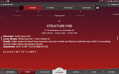
- Incident location and type are sent to assigned tablets with audible alert. Accuracy advisories provided if location is estimated.
- Incident updates sent by dispatch center instantly update on tablet display with pop-up advisory.
- Incidents are mapped automatically, with familiar “pinch-zoom” interface.
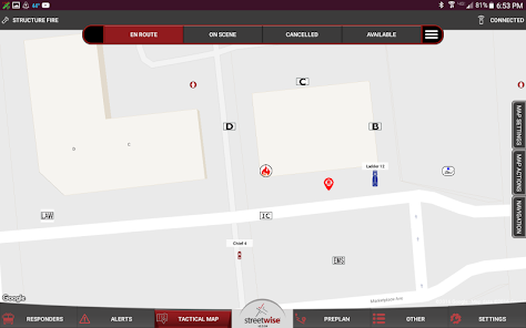
- AVL shows the location of other units in real time, see who’s on your call and who’s not.
- Tap-to-display data for other units shows apparatus type, pump and tank capacity, EMS level and staffing.
- Choices of icons and colors for various apparatus types, rotate in direction of travel.
- Web-based AVL display available for use at dispatch console or headquarters.
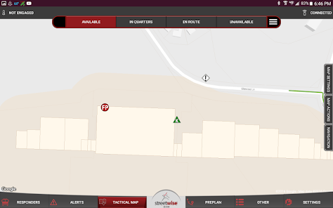
- Community hazards and preplan points are displayed graphically on the tactical map and can be shared with other agencies.
- Navigational routing is available, with turn-by-turn directions available.
- Hydrant layer shows location and touch-to-display data for water supply.
- Choices of icons for various types of hydrants or drafting points.
- Switch to satellite photo view or terrain view for enhanced situational awareness.
- Google StreetView is integrated for available interactive 360 degree photo.
- Tactical waypoints can be dropped on the map and instantly synchronized to all responding tablets for designation of staging areas, incident hazards, fire progression and more. NIMS icons available.
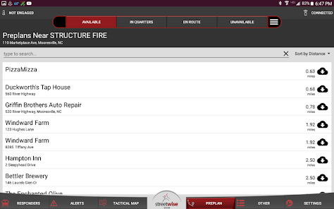
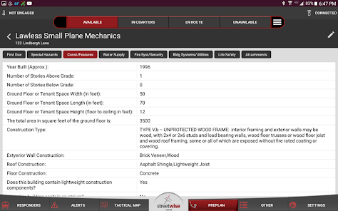
- Pre-incident plans are stored in the server and accessed on any responding tablet. Preplans can be shared with other agencies.
- Preplans can be selectively cached to device storage for use when no broadband is available.
- Exclusive “Preplan Wizard”, complete front-end pre-incident planning surveys for standalone business, master or tenant spaces allow field collection of preplans with the tablet.
- Preplan photos can be added right from the tablet during the survey. Additional attachments can be uploaded.
- New preplans are automatically synchronized to the server for immediate use by all devices.
- Instant photo “share” feature can send incident photos to other responding units or be used for post-disaster damage assessment. Photos are retrievable from administrative web portal.
- Device-to-group instant messaging. Message everyone or just the units on your call.
- Status buttons send instant timestamps to the server for later retrieval or sharing to CAD and NFIRS. All units’ current status displays to other responders.
- Live interface with Emergency Reporting® auto-creates NFIRS incident report, fills in unit times and tactical screen actions.
- Web-accessible agency log records every event and activity.
- Administrative web portal allows department to set icons, permissions, and entitlements for devices.
- Print, list, export, or import preplan data or finished preplans right from the web portal.
- CAD-independent, uses common data exports or optional dispatch workstation app.
- CAD transfers can use email, SMS, FTP, SFTP, XML, or a custom API.
- Basic, simple user interface with large, easy-to-read touch commands and limited menus.
- Bi-directional API interfaces available for sharing AVL and status buttons back to CAD systems.
This application includes a video demo of the full product. Full activation requires your department to have a subscription to StreetWise CADlink data services and a link to be setup with your dispatch center or system.
Features:
- Incident location and type are sent to assigned tablets with audible alert. Accuracy advisories provided if location is estimated.
- Incident updates sent by dispatch center instantly update on tablet display with pop-up advisory.
- Incidents are mapped automatically, with familiar “pinch-zoom” interface.
- AVL shows the location of other units in real time, see who’s on your call and who’s not.
- Tap-to-display data for other units shows apparatus type, pump and tank capacity, EMS level and staffing.
- Choices of icons and colors for various apparatus types, rotate in direction of travel.
- Web-based AVL display available for use at dispatch console or headquarters.
- Community hazards and preplan points are displayed graphically on the tactical map and can be shared with other agencies.
- Navigational routing is available, with turn-by-turn directions available.
- Hydrant layer shows location and touch-to-display data for water supply.
- Choices of icons for various types of hydrants or drafting points.
- Switch to satellite photo view or terrain view for enhanced situational awareness.
- Google StreetView is integrated for available interactive 360 degree photo.
- Tactical waypoints can be dropped on the map and instantly synchronized to all responding tablets for designation of staging areas, incident hazards, fire progression and more. NIMS icons available.
- Pre-incident plans are stored in the server and accessed on any responding tablet. Preplans can be shared with other agencies.
- Preplans can be selectively cached to device storage for use when no broadband is available.
- Exclusive “Preplan Wizard”, complete front-end pre-incident planning surveys for standalone business, master or tenant spaces allow field collection of preplans with the tablet.
- Preplan photos can be added right from the tablet during the survey. Additional attachments can be uploaded.
- New preplans are automatically synchronized to the server for immediate use by all devices.
- Instant photo “share” feature can send incident photos to other responding units or be used for post-disaster damage assessment. Photos are retrievable from administrative web portal.
- Device-to-group instant messaging. Message everyone or just the units on your call.
- Status buttons send instant timestamps to the server for later retrieval or sharing to CAD and NFIRS. All units’ current status displays to other responders.
- Live interface with Emergency Reporting® auto-creates NFIRS incident report, fills in unit times and tactical screen actions.
- Web-accessible agency log records every event and activity.
- Administrative web portal allows department to set icons, permissions, and entitlements for devices.
- Print, list, export, or import preplan data or finished preplans right from the web portal.
- CAD-independent, uses common data exports or optional dispatch workstation app.
- CAD transfers can use email, SMS, FTP, SFTP, XML, or a custom API.
- Basic, simple user interface with large, easy-to-read touch commands and limited menus.
- Bi-directional API interfaces available for sharing AVL and status buttons back to CAD systems.
Oxirgi yangilanish
Xavfsizlik — dastur ishlab chiquvchilar maʼlumotlaringizni qanday jamlashi va ulashishini tushinishdan boshlanadi. Maʼlumotlar maxfiyligi va xavfsizlik amaliyotlari ilovadan foydalanish, hudud va yoshga qarab farq qilishi mumkin. Bu axborot dastur ishlab chiquvchi tomonidan taqdim etilgan va keyinchalik yangilanishi mumkin.


Nima yangiliklar
Minor bug fixes