Onsite Survey GPS Camera Stamp
包含广告应用内购商品
3.9star
293条评价
5万+
次下载

适合所有人
info


关于此应用
Do you want to track the progress of your onsite construction work? This survey gps camera app will capture your onsite construction project pictures with a unique stamp. This stamp includes your company name, logo, project name, notes, date and time, and location information.
Ready to elevate your survey GPS camera experience? Our cutting-edge survey gps field camera application ensures seamless tracking of your onsite survey construction, or field projects. Easily capture and personalize project images with your company logo, project details, GPS Location stamps, and the precise date and timestamp camera with auto-add timestamp & location to photos.
A powerful in-app survey gps camera 📸 not only captures the visual essence of your onsite construction but stamps it with the precision of GPS coordinates and timestamps. It ensures that every geotag photo tells a compelling story of your project's journey 🚀
❑ Features you will enjoy with this Onsite Survey GPS Camera Stamp app
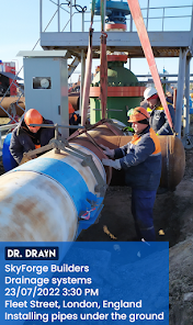
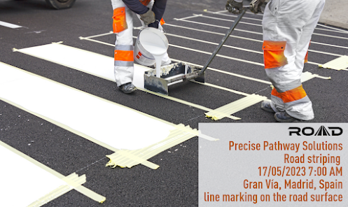
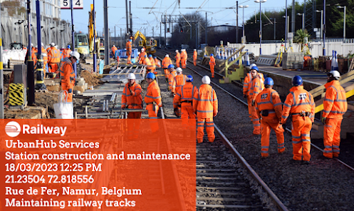
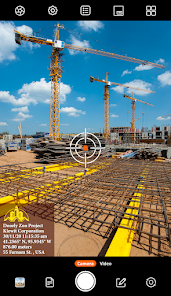
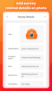
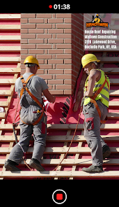
🏗️ Project Name: Add your project name along with this camera with date and time stamp to photos and videos.
🏬 Company Name: Mention the name and logo of your construction company to add a professional touch to your visual documentation in this onsite survey gps camera.
📝 Notes: You can write notes on stamps for your visual records, which will ensure that every detail, insight, or observation is captured and retained.
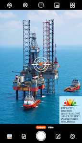
📍 Onsite GPS Camera for Surveying: Survey geotag Photos with GPS coordinates improve accuracy by converting your image into a geo-referenced location on the stamp.
📆 Date and Time Camera: Add a date and time stamp to help you recall when and where you captured your onsite project photos with survey gps camera photo with the location app
📌 Address: Record your field by adding real-time gps stamps, which include gps coordinates, gps location & more.
🎯 Accuracy: This survey gps camera photo with location assures you to provide stamping for your photos and videos
🎚️ Altitude Stamp for Surveyors: The altitude feature assists onsite professionals in making informed decisions regarding grading, excavation, and elevation changes.
Survey GPS Camera is the best camera app for work to stamp GPS Stamps which is designed for professionals. It shows you when and where you have clicked on your success. You can share your pictures with your clients, colleagues, and other people directly from the onsite field.
Onsite Survey GPS Camera Stamp App will benefit these professions:
➥ Construction professionals
➥ Project manager
➥ Civil Engineer
➥ Surveyors
➥ Photographers
➥ Architecture
➥ Real Estate Agents
➥ Geologists
➥ Businessmen
Auto GPS Stamp works tirelessly in the background for your onsite work so that you can work without the hassles of manual documentation. Survey GPS Camerageotag photos & integrates project details, company information, and notes with GPS coordinates, accuracy metrics, altitude, and date and time stamps, making every picture a valuable source of information.
Download the Surveyor's favorite Onsite Survey GPS Camera Stamp app now to map your onsite construction work. Add your project details to the stamp to capture and save your onsite construction progress. It's not about just taking pictures; it's about elevating your workflow. Work smart with the GPS Stamp because your work deserves nothing less. 📸🕔🚀
Ready to elevate your survey GPS camera experience? Our cutting-edge survey gps field camera application ensures seamless tracking of your onsite survey construction, or field projects. Easily capture and personalize project images with your company logo, project details, GPS Location stamps, and the precise date and timestamp camera with auto-add timestamp & location to photos.
A powerful in-app survey gps camera 📸 not only captures the visual essence of your onsite construction but stamps it with the precision of GPS coordinates and timestamps. It ensures that every geotag photo tells a compelling story of your project's journey 🚀
❑ Features you will enjoy with this Onsite Survey GPS Camera Stamp app
🏗️ Project Name: Add your project name along with this camera with date and time stamp to photos and videos.
🏬 Company Name: Mention the name and logo of your construction company to add a professional touch to your visual documentation in this onsite survey gps camera.
📝 Notes: You can write notes on stamps for your visual records, which will ensure that every detail, insight, or observation is captured and retained.
📍 Onsite GPS Camera for Surveying: Survey geotag Photos with GPS coordinates improve accuracy by converting your image into a geo-referenced location on the stamp.
📆 Date and Time Camera: Add a date and time stamp to help you recall when and where you captured your onsite project photos with survey gps camera photo with the location app
📌 Address: Record your field by adding real-time gps stamps, which include gps coordinates, gps location & more.
🎯 Accuracy: This survey gps camera photo with location assures you to provide stamping for your photos and videos
🎚️ Altitude Stamp for Surveyors: The altitude feature assists onsite professionals in making informed decisions regarding grading, excavation, and elevation changes.
Survey GPS Camera is the best camera app for work to stamp GPS Stamps which is designed for professionals. It shows you when and where you have clicked on your success. You can share your pictures with your clients, colleagues, and other people directly from the onsite field.
Onsite Survey GPS Camera Stamp App will benefit these professions:
➥ Construction professionals
➥ Project manager
➥ Civil Engineer
➥ Surveyors
➥ Photographers
➥ Architecture
➥ Real Estate Agents
➥ Geologists
➥ Businessmen
Auto GPS Stamp works tirelessly in the background for your onsite work so that you can work without the hassles of manual documentation. Survey GPS Camerageotag photos & integrates project details, company information, and notes with GPS coordinates, accuracy metrics, altitude, and date and time stamps, making every picture a valuable source of information.
Download the Surveyor's favorite Onsite Survey GPS Camera Stamp app now to map your onsite construction work. Add your project details to the stamp to capture and save your onsite construction progress. It's not about just taking pictures; it's about elevating your workflow. Work smart with the GPS Stamp because your work deserves nothing less. 📸🕔🚀
更新日期


评分和评价
3.9
289条评价


