

savvy navvy : Boat Navigation

3.0star
2.11K reviewsinfo
500K+
Downloads

PEGI 3
info


About this app
TEST FOR FREE: Download savvy navvy and see how it works for two weeks
SUBSCRIBE: Start your 1-year subscription and gain:
savvy navvy put all the essential marine information you need, in one place. Tides, Tidal graphs, weather forecasts, automatically updated chart data, routing, GPS tracking, marina information (and more) at the touch of a button. One subscription, one app, multiple devices - it doesn't matter if you are on a motor boat, sailing yacht, SUP Paddleboard, Kayak or jetski.
FEATURES
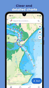
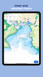
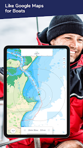
CHART NAVIGATION
Get access to all savvy charts, wherever we have coverage. Our sailing maps have been custom-built using quality data from the UKHO (United Kingdom Hydrographic Office), NOAA and other hydrographic offices around the world to provide easy and safe sailing navigation - like a chart plotter in your pocket.
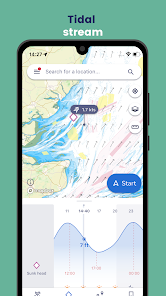
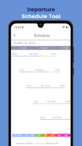
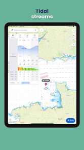
TIDE HEIGHTS GRAPH & TIDAL STREAMS
View tidal heights and streams on our tide chart. Scroll through the tidal graph to see changes in tidal highs and lows over time.
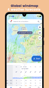
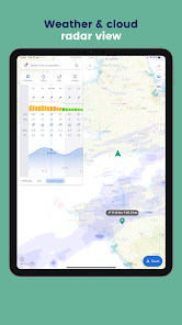
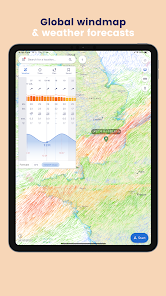
MARINE WEATHER FORECASTS
Use the weather forecast graph to scroll through days and times to see the effect on weather conditions, wind strength and direction. Use the wind icon to see a visual overlay of wind barbs!
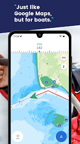
ACTIVE TRACKING
Use boat tracking to hone in on your boat GPS location, see your course over ground (COG) and view your speed over ground (SOG). savvy navvy is essentially your nautical GPS giving you a compass heading to steer with a tide calculation!
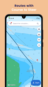
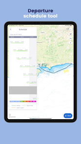
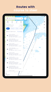
AUTOMATIC ROUTING
Plot a sailing route in seconds with an automatic course to steer. Drop a pin to indicate your start and finish points and savvy navvy will quickly plot a route to sail taking into account wind, chart and tidal data.
1. Drop a pin at your start and finish locations
2. Calculate your route
3. Preview your route and get an Estimated Time of Arrival
4. Export your route for use with your chart plotter
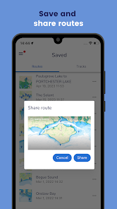
ROUTE EXPORT
Marine navigation made easy! Plot your route with savvy navvy and then export the GPX file for use with your chart plotter. Boating navigation couldn’t be easier!
IMPORT MARKERS FROM OTHER APPS
Import your saved markers from other apps, including Navionics, C-MAP, iNavX and even from your chart plotter. Quickly and easily upload your saved locations (using a .gpx file) into your savvy navvy app. Ensure your valuable data continues to enhance your boating experience.
ANCHOR ALARM
An addition of an Anchor Alarm functionality to keep you safe when anchored. Allows the user to set a drift/swing area, which you will receive a warning if crossed.
MARINA & ANCHORAGE INFORMATION
Tap our dedicated icons for local marina and anchorage information on our sailing map and find:
* VHF channel
* Anchorage holding
* Overnight weather and wind direction information
* Mooring details
* Restaurants, bathrooms and toilets
* Fuel docks
* Water
* And much more...
DEDICATED CUSTOMER SERVICE
Our team is on standby to help you whenever you need us for questions about boating navigation, sailing, the chart plotter or anything else. Our in-app chatbot is managed by real team members with extensive experience in marine navigation who will help you get the most out of your boat navigation app!
ADDITIONAL VESSEL TYPES
Support for Paddleboarders, Kayakers and Jetskis
We added new vessel types into our on-water family, giving them the same features and functions that are tailored specifically to them.
Read our terms of service here: https://www.savvy-navvy.com/terms-of-service
SUBSCRIBE: Start your 1-year subscription and gain:
savvy navvy put all the essential marine information you need, in one place. Tides, Tidal graphs, weather forecasts, automatically updated chart data, routing, GPS tracking, marina information (and more) at the touch of a button. One subscription, one app, multiple devices - it doesn't matter if you are on a motor boat, sailing yacht, SUP Paddleboard, Kayak or jetski.
FEATURES
CHART NAVIGATION
Get access to all savvy charts, wherever we have coverage. Our sailing maps have been custom-built using quality data from the UKHO (United Kingdom Hydrographic Office), NOAA and other hydrographic offices around the world to provide easy and safe sailing navigation - like a chart plotter in your pocket.
TIDE HEIGHTS GRAPH & TIDAL STREAMS
View tidal heights and streams on our tide chart. Scroll through the tidal graph to see changes in tidal highs and lows over time.
MARINE WEATHER FORECASTS
Use the weather forecast graph to scroll through days and times to see the effect on weather conditions, wind strength and direction. Use the wind icon to see a visual overlay of wind barbs!
ACTIVE TRACKING
Use boat tracking to hone in on your boat GPS location, see your course over ground (COG) and view your speed over ground (SOG). savvy navvy is essentially your nautical GPS giving you a compass heading to steer with a tide calculation!
AUTOMATIC ROUTING
Plot a sailing route in seconds with an automatic course to steer. Drop a pin to indicate your start and finish points and savvy navvy will quickly plot a route to sail taking into account wind, chart and tidal data.
1. Drop a pin at your start and finish locations
2. Calculate your route
3. Preview your route and get an Estimated Time of Arrival
4. Export your route for use with your chart plotter
ROUTE EXPORT
Marine navigation made easy! Plot your route with savvy navvy and then export the GPX file for use with your chart plotter. Boating navigation couldn’t be easier!
IMPORT MARKERS FROM OTHER APPS
Import your saved markers from other apps, including Navionics, C-MAP, iNavX and even from your chart plotter. Quickly and easily upload your saved locations (using a .gpx file) into your savvy navvy app. Ensure your valuable data continues to enhance your boating experience.
ANCHOR ALARM
An addition of an Anchor Alarm functionality to keep you safe when anchored. Allows the user to set a drift/swing area, which you will receive a warning if crossed.
MARINA & ANCHORAGE INFORMATION
Tap our dedicated icons for local marina and anchorage information on our sailing map and find:
* VHF channel
* Anchorage holding
* Overnight weather and wind direction information
* Mooring details
* Restaurants, bathrooms and toilets
* Fuel docks
* Water
* And much more...
DEDICATED CUSTOMER SERVICE
Our team is on standby to help you whenever you need us for questions about boating navigation, sailing, the chart plotter or anything else. Our in-app chatbot is managed by real team members with extensive experience in marine navigation who will help you get the most out of your boat navigation app!
ADDITIONAL VESSEL TYPES
Support for Paddleboarders, Kayakers and Jetskis
We added new vessel types into our on-water family, giving them the same features and functions that are tailored specifically to them.
Read our terms of service here: https://www.savvy-navvy.com/terms-of-service
Updated on
Safety starts with understanding how developers collect and share your data. Data privacy and security practices may vary based on your use, region and age The developer provided this information and may update it over time.


Ratings and reviews
2.9
1.86K reviews

Jeffery Pyle
- Flag inappropriate
11 June 2024
I boat on the Lake of the Ozarks and I need to see landmarks, businesses, points of interest and similar. Some lakefront business can't be found or the names are wrong. Some addresses can't be found. Navigation is OK but the waypoints are on the shoreline. Literally. I can't see myself using this app regularly nor do I see any value in upgrading to the paid version. I need to save locations, not routes.
4 people found this review helpful
savvy navvy
11 June 2024
Hey Jeffrey - if you long hold on the chart anywhere, you can drop and save a pin on that location. You can then rename it and easily navigate back to it. You can also import saved points from older and less intuitive apps.... ;-)
That all works in the free version of the app.

matthew12345678912
- Flag inappropriate
- Show review history
20 May 2024
Tried the free trial. Playstore charges your card £0 initially. Easy to cancel in playstore home page in payment and subscription tab. I found the app on the whole good. However it didn't meet my needs concerning low tides in estuaries. It would plot a route yet suggest times when there would be no water in the upper estuary at all. Worked well where there was deeper water. Personally I think a price of £40 per annum would seem reasonable. I find £80 pounds plus per annum too much.
8 people found this review helpful
savvy navvy
23 May 2024
Hi Matthew, thank you for trying the app and leaving a review. We do have 3 subscriptions with the cheapest starting at £39 per year.

Liv Ava
- Flag inappropriate
15 June 2024
Convenient, reliable, so much easier than a map for the captain to gain quick understanding and make decisions, especially in trying circumstances and/or new environment. I like that it covers some Canadian/ American lakes such as Memphremagog, where winds and weather change promptly. The road mapping offers best precision once you are out of your dock and somehow out of your bay.
6 people found this review helpful
What's new
Bug fixes.


