

행정구역 지도 - 행정 & 법정 & 학구도
Contains ads

10K+
Downloads

Everyone
info

About this app
The Administrative District Map app allows you to easily view South Korea's administrative districts, legal districts, and elementary school attendance areas (school districts) on a map.
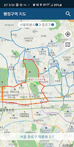
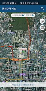
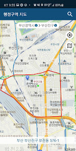
Swiping the screen displays "towns, townships, and districts" (villages, towns, and villages), along with "city, county, and districts."
You can choose between standard and satellite map modes.
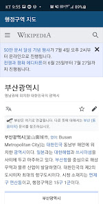
Tapping the "Metropolitan Province" or "City, County, and District" headings at the top will display relevant information from Wikimedia.
You can use the search function to navigate to the corresponding area on the map by selecting "town, township, and district."
[App Permissions]
Required Permissions for Using the Administrative District Map App
ㆍLocation: Confirms your location when searching for administrative districts.
※ This app was developed to provide general administrative district, legal district, and school district information and is not affiliated with the official government or the Ministry of Education.
※ Administrative districts, legal districts, and school districts are derived from the Public Data Portal (www.data.go.kr).
Swiping the screen displays "towns, townships, and districts" (villages, towns, and villages), along with "city, county, and districts."
You can choose between standard and satellite map modes.
Tapping the "Metropolitan Province" or "City, County, and District" headings at the top will display relevant information from Wikimedia.
You can use the search function to navigate to the corresponding area on the map by selecting "town, township, and district."
[App Permissions]
Required Permissions for Using the Administrative District Map App
ㆍLocation: Confirms your location when searching for administrative districts.
※ This app was developed to provide general administrative district, legal district, and school district information and is not affiliated with the official government or the Ministry of Education.
※ Administrative districts, legal districts, and school districts are derived from the Public Data Portal (www.data.go.kr).
Updated on
Safety starts with understanding how developers collect and share your data. Data privacy and security practices may vary based on your use, region, and age. The developer provided this information and may update it over time.

This app may share these data types with third parties
Device or other IDs

No data collected
Learn more about how developers declare collection

Data isn’t encrypted
Data can’t be deleted
What’s new
- 주소표시 기능 복구
- 도로명, 우편번호 추가
- 도로명, 우편번호 추가
App support
About the developer
장도곤
docko@hanmail.net
유엔로 246
108동 1505호
남구, 부산광역시 48409
South Korea


