

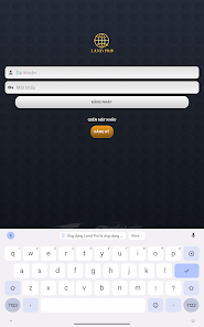
Land Pro

1K+
Downloads

Everyone
info

About this app
Land Pro application is the leading application to view Planning and Land information
Main functions of the application:
1. Locate whether the user's current land plot is in the planning area or not.
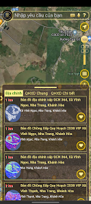
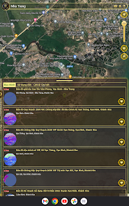
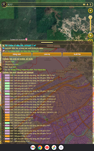
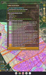
2. Look up planning information by:
- AI voice commands, follow the map around here, the map around us
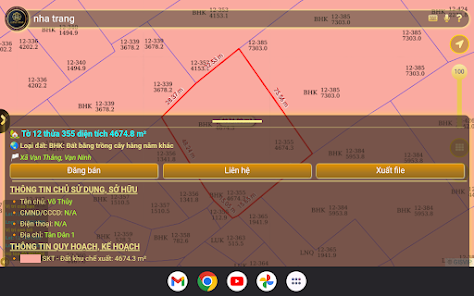
- Look up the number of sheets, number of land plots
- View the location of the red book and pink book on the map, through the "Red Book" function to Scan the set of coordinate points with the Live Camera, scan the coordinate points through the images available in the photo library, Scan the coordinates of the image through google translate, or read coordinates directly from *.txt, *.csv . files
- GPS positioning directions to find the location of the land plot on the map
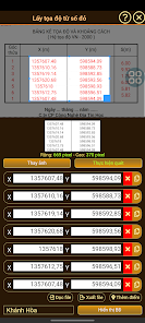
- Convert vn 2000 coordinates to geographic coordinates
- Set the reference system: Default to the universal WGS84 reference system, Users can convert to another reference system available in the "Reference system" section
- Take a photo of the coordinates of the land plot that the user wants to look up
- Take screenshots and share screenshots via social networking platforms or save to user's local storage
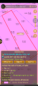
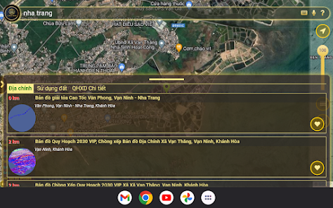
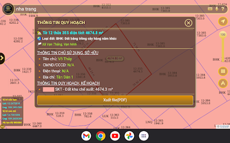
3. View information by clicking directly on the map.
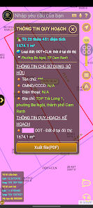
4. Save land parcel information.
5. Collection of plannings:
- Cadastral maps
- Detailed construction planning
- Land use planning
- Other planning on the map background for easy tracking
6. Read point coordinates via file: *.txt, *.csv
7. Record coordinate files: *.txt, *.csv for measurement function, calculate perimeter, area
8. Record *.pdf file for land plot information, from online map reading results
9. Field notes through direct interaction by creating Maker or through Surveying and measuring tools for live GPS functionality;
Main functions of the application:
1. Locate whether the user's current land plot is in the planning area or not.
2. Look up planning information by:
- AI voice commands, follow the map around here, the map around us
- Look up the number of sheets, number of land plots
- View the location of the red book and pink book on the map, through the "Red Book" function to Scan the set of coordinate points with the Live Camera, scan the coordinate points through the images available in the photo library, Scan the coordinates of the image through google translate, or read coordinates directly from *.txt, *.csv . files
- GPS positioning directions to find the location of the land plot on the map
- Convert vn 2000 coordinates to geographic coordinates
- Set the reference system: Default to the universal WGS84 reference system, Users can convert to another reference system available in the "Reference system" section
- Take a photo of the coordinates of the land plot that the user wants to look up
- Take screenshots and share screenshots via social networking platforms or save to user's local storage
3. View information by clicking directly on the map.
4. Save land parcel information.
5. Collection of plannings:
- Cadastral maps
- Detailed construction planning
- Land use planning
- Other planning on the map background for easy tracking
6. Read point coordinates via file: *.txt, *.csv
7. Record coordinate files: *.txt, *.csv for measurement function, calculate perimeter, area
8. Record *.pdf file for land plot information, from online map reading results
9. Field notes through direct interaction by creating Maker or through Surveying and measuring tools for live GPS functionality;
Updated on
Safety starts with understanding how developers collect and share your data. Data privacy and security practices may vary based on your use, region, and age. The developer provided this information and may update it over time.

No data shared with third parties
Learn more about how developers declare sharing

No data collected
Learn more about how developers declare collection

Data is encrypted in transit

You can request that data be deleted
What's new
1. Tập hợp các quy hoạch:
- Bản đồ địa chính
- Quy hoạch chi tiết xây dựng
- Quy hoạch sử dụng đất
- Quy hoạch khác
2. Ghi chú thực địa maker
3. Fix Clipboard
4. Fix nhập liệu tự cuộn lên
- Bản đồ địa chính
- Quy hoạch chi tiết xây dựng
- Quy hoạch sử dụng đất
- Quy hoạch khác
2. Ghi chú thực địa maker
3. Fix Clipboard
4. Fix nhập liệu tự cuộn lên