Canoeing navigation
2.8star
2.87K reviews
50K+
Downloads

Everyone
info


About this app
Guide and navigation for paddling Czech rivers.
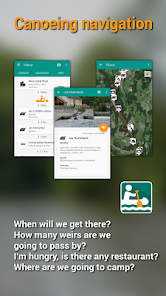
When will we get there? How many weirs are we going to pass by? Which line to choose? I'm hungry, is there any restaurant? Where are we going to camp? How is called the castle nearby? All of this and lot more you can easily and quickly find in the mobile app Canoeing navigation. In addition there is also available a Web version of Canoeing navigation at http://www.vodackanavigace.cz.
Canoeing navigation offers:
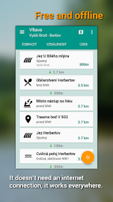
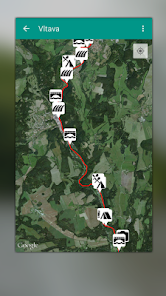
- Detailed navigation and guide for paddling Czech rivers
- Detailed information about every mentioned place
- More than 150 well-arranged schemas of the weirs
- Information about current runnability of each river section
Important properties
- Application is completely for free, it doesn’t contain any inner payments.
- Application doesn’t need access to the internet (except to maps, it can happen they couldn’t work without access to Wi-Fi)
- Application is for those who practise touristic canoeing, it doesn’t contain any information about paddling white water.
What kind of data we provide
In Canoeing navigation you can find a detailed guide and navigation of ten most famous Czech rivers, which are: Vltava, Sázava, Otava, Ohře, Lužnice (including the new river), Nežárka, Berounka ,Orlice (calm and wild one), Morava a Dyje. We are going to add more rivers in recent time.
For each river we have in evidence weirs, rapids, classes of difficulty, campsites, bars, canteens, restaurants, sights, villages, bridges, tributaries, information about traffic, hydrometers and other important information for paddlers.
Data contained in Canoeing navigation is not copied from any older navigation. All the information is manually assigned and described according to the current state. On creating and maintenance we are cooperating with our local partners usually boat rentals. They work daily on these rivers, so they know them really well. Thanks to them we provide actual information.
In addition to this application offers possibility to send us a proposal to correct or complete the information in case there occur any mistake or some information would be missing. We will be glad, if you get involved and help us to keep the guide actual.
When will we get there? How many weirs are we going to pass by? Which line to choose? I'm hungry, is there any restaurant? Where are we going to camp? How is called the castle nearby? All of this and lot more you can easily and quickly find in the mobile app Canoeing navigation. In addition there is also available a Web version of Canoeing navigation at http://www.vodackanavigace.cz.
Canoeing navigation offers:
- Detailed navigation and guide for paddling Czech rivers
- Detailed information about every mentioned place
- More than 150 well-arranged schemas of the weirs
- Information about current runnability of each river section
Important properties
- Application is completely for free, it doesn’t contain any inner payments.
- Application doesn’t need access to the internet (except to maps, it can happen they couldn’t work without access to Wi-Fi)
- Application is for those who practise touristic canoeing, it doesn’t contain any information about paddling white water.
What kind of data we provide
In Canoeing navigation you can find a detailed guide and navigation of ten most famous Czech rivers, which are: Vltava, Sázava, Otava, Ohře, Lužnice (including the new river), Nežárka, Berounka ,Orlice (calm and wild one), Morava a Dyje. We are going to add more rivers in recent time.
For each river we have in evidence weirs, rapids, classes of difficulty, campsites, bars, canteens, restaurants, sights, villages, bridges, tributaries, information about traffic, hydrometers and other important information for paddlers.
Data contained in Canoeing navigation is not copied from any older navigation. All the information is manually assigned and described according to the current state. On creating and maintenance we are cooperating with our local partners usually boat rentals. They work daily on these rivers, so they know them really well. Thanks to them we provide actual information.
In addition to this application offers possibility to send us a proposal to correct or complete the information in case there occur any mistake or some information would be missing. We will be glad, if you get involved and help us to keep the guide actual.
Updated on
Safety starts with understanding how developers collect and share your data. Data privacy and security practices may vary based on your use, region, and age. The developer provided this information and may update it over time.

No data shared with third parties
Learn more about how developers declare sharing

No data collected
Learn more about how developers declare collection

Data isn’t encrypted
Data can’t be deleted
Ratings and reviews
2.8
2.8K reviews

JAN Stehlík
- Flag inappropriate
- Show review history
June 16, 2024
We just canoed down the Ohře. GPS feature super heplful. Also th pin of "from" and "to" super helpfull. Thanks! Super, sjeli jsme Ohři a bez problémů. Funkce s GPS byla super helpful! Díky! Update one year on, we just canoed down the Vltava as well, the app worked perfect again. The pictures of weirs (Český Krumlov is full of them) are super helpfull again! This app rocks!

Stepan Kornyakov
- Flag inappropriate
- Show review history
June 23, 2024
Absolutely great! Offers all information that one might need on the river.

Jiří Hanuš
- Flag inappropriate
August 20, 2021
Great, but I can't switch languages. It takes settings from system, which I do not want.
5 people found this review helpful