
Water Maps
5K+
Downloads

Everyone
info


About this app
The goals of this application are
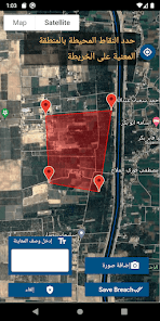
• Help users find the nearest source of irrigation water and display its management information.
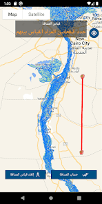
• Show waterway data where the user is standing.
• Determine the kilometer location on the watercourse for any specific point
• Display of the geographic coordinates of where the user is standing.
• View on the background of satellite images or background Google Maps methods of its services.
• Sharing coordinates via WhatsApp
In general, this application helps users by showing their locations around the areas of water networks, canals and water sources in order to help them reach the nearest water and sewage source to them to save every drop of water and avoid road loss and accidents.
• Help users find the nearest source of irrigation water and display its management information.
• Show waterway data where the user is standing.
• Determine the kilometer location on the watercourse for any specific point
• Display of the geographic coordinates of where the user is standing.
• View on the background of satellite images or background Google Maps methods of its services.
• Sharing coordinates via WhatsApp
In general, this application helps users by showing their locations around the areas of water networks, canals and water sources in order to help them reach the nearest water and sewage source to them to save every drop of water and avoid road loss and accidents.
Updated on
Safety starts with understanding how developers collect and share your data. Data privacy and security practices may vary based on your use, region, and age. The developer provided this information and may update it over time.

No data shared with third parties
Learn more about how developers declare sharing

This app may collect these data types
Personal info and Device or other IDs

Data is encrypted in transit
What’s new
تغيير عداد الكيلومترى الى 3 بعد العلامة
App support
phone
Phone number
+201207199086
About the developer
احمد وجدى امين على
ahmed.w.amin@gmail.com
Egypt


