
SatFish Offshore Fishing App
2.9star
20 reviews
1K+
Downloads

Everyone
info


About this app
Find the Bite. Fast. Even Offshore.
Bring the full power of SatFish’s advanced fishing maps to your mobile device and stay locked in on the hot bite zone — whether you're at the dock or 100 miles offshore.
SatFish Mobile gives you instant access to high-definition satellite imagery and real-time ocean data, turning your phone or tablet into a full-featured offshore fishing tool. Plan smarter, fish harder, and make every trip count.
Key Features:
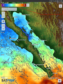
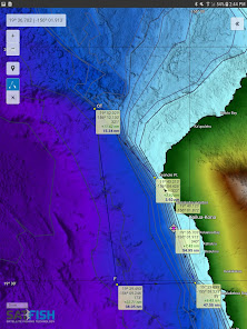
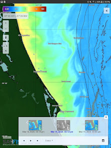
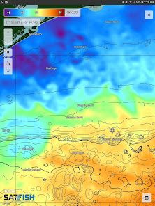
- High-Resolution SST Charts – Spot temperature breaks to zero in on pelagic bite zones.
- Cloud-Free SST & Multi-Day Composites - Full coverage even when skies are cloudy.
- Chlorophyll & Water Clarity Layers – Find clean, productive water that holds fish.
- 5-Day Wind Forecasts – Plan around wind and sea conditions with precision.
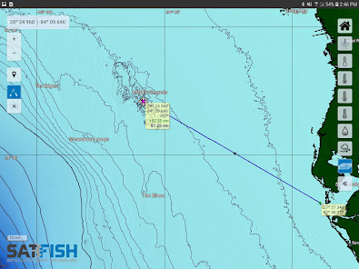
- GPS Tracking on Downloaded Maps – Follow your live position even with no cell signal.
- Offline Access – Automatically saves recently viewed maps for use offshore.
- Integrated Trip Planning Tools – Map out location and distance to the bite zone, draw routes, and plan smarter.
- Covers All U.S. Offshore Regions – From the Gulf of Maine to the Pacific Coast and Hawaii.
Why SatFish?
Don’t waste time burning fuel through empty water. SatFish combines the latest satellite mapping technology and decades of offshore fishing experience to guide you directly to the most productive offshore fishing grounds - fast. Built by fishermen, for fishermen.
Requirements:
- Active SatFish.com subscription
- WiFi or cellular connection to retrieve charts
- GPS-enabled device for real-time location tracking
Subscription Details
30-day free trial, then $129 USD / year. Full access to all regions and features on web and mobile.
Download SatFish Mobile today and fish with the confidence of satellite-powered precision wherever the bite takes you!
Bring the full power of SatFish’s advanced fishing maps to your mobile device and stay locked in on the hot bite zone — whether you're at the dock or 100 miles offshore.
SatFish Mobile gives you instant access to high-definition satellite imagery and real-time ocean data, turning your phone or tablet into a full-featured offshore fishing tool. Plan smarter, fish harder, and make every trip count.
Key Features:
- High-Resolution SST Charts – Spot temperature breaks to zero in on pelagic bite zones.
- Cloud-Free SST & Multi-Day Composites - Full coverage even when skies are cloudy.
- Chlorophyll & Water Clarity Layers – Find clean, productive water that holds fish.
- 5-Day Wind Forecasts – Plan around wind and sea conditions with precision.
- GPS Tracking on Downloaded Maps – Follow your live position even with no cell signal.
- Offline Access – Automatically saves recently viewed maps for use offshore.
- Integrated Trip Planning Tools – Map out location and distance to the bite zone, draw routes, and plan smarter.
- Covers All U.S. Offshore Regions – From the Gulf of Maine to the Pacific Coast and Hawaii.
Why SatFish?
Don’t waste time burning fuel through empty water. SatFish combines the latest satellite mapping technology and decades of offshore fishing experience to guide you directly to the most productive offshore fishing grounds - fast. Built by fishermen, for fishermen.
Requirements:
- Active SatFish.com subscription
- WiFi or cellular connection to retrieve charts
- GPS-enabled device for real-time location tracking
Subscription Details
30-day free trial, then $129 USD / year. Full access to all regions and features on web and mobile.
Download SatFish Mobile today and fish with the confidence of satellite-powered precision wherever the bite takes you!
Updated on
Safety starts with understanding how developers collect and share your data. Data privacy and security practices may vary based on your use, region, and age. The developer provided this information and may update it over time.

No data shared with third parties
Learn more about how developers declare sharing

No data collected
Learn more about how developers declare collection

Data is encrypted in transit

You can request that data be deleted
Ratings and reviews
2.9
20 reviews

Shaina Cox
- Flag inappropriate
February 4, 2025
Satfish is an awesome app! It helps me find fish easily, and the website blogs provide great tips and tricks. I love how interactive it is, and I can see everything I need right at my fingertips!

chris cook
- Flag inappropriate
July 30, 2022
Thank God they have a 30 day trial. Maps take for ever to load, and only show small spots of coverage. Don't waste your time!
2 people found this review helpful

Michael Maurice
- Flag inappropriate
July 17, 2022
Anyone installing this app is going to be completely confused since the there is no indication that registration and account setup has to be first done on the web site. There should be a registration button that takes you to a web registration page.
7 people found this review helpful
What’s new
Update android framework, and minor bug fixes.
App support
About the developer
BD OUTDOORS, LLC
webdev@bdoutdoors.com
4010 Morena Blvd
San Diego, CA 92117
United States
+1 619-992-6099


