Handy GPS (subscription)
In-app purchases

4.3star
994 reviews
100K+
Downloads

Everyone
info

About this app
The perfect companion for your next outdoor adventure. Seek, find, record and return home with Handy GPS.
This app requires payment of an annual subscription to be fully functional. If this is not paid it will still run, but with limited functionality.
This app is a powerful navigation tool designed for outdoors sports like hiking, bushwalking, tramping, mountain biking, kayaking, boating, horse trail riding, geocaching. Its also useful for surveying, mining, archaeology, and forestry applications. Its simple to use and works even in the remotest back country since it doesn't require network connectivity. It allows you to work in UTM or lat/lon coordinates so you can even use it with your paper maps.
NOTE: Allow the app to always use GPS, and turn off battery optimisation for the app to reliably record tracklogs when the phone screen is off.
BASE FEATURES:
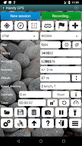
* Shows your current coordinates, altitude, speed, direction of travel, and distance travelled in metric, imperial/US, or nautical units.
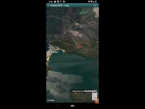
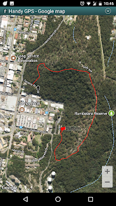
* Can store your current location as a waypoint, and record a track log to show where you've been on a map.
* Data can be imported from and exported to KML and GPX files.
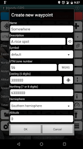
* Allows manual entry of waypoints in UTM, MGRS and lat/lon coords.
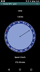
* Can guide you to a waypoint using the "Goto" screen, and optionally sound an alert when when you're getting close.
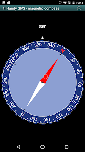
* Has a compass page which works on devices with magnetic field sensors.
* Automatically computes the local geoid offset to improve altitude accuracy
* Supports the world-wide WGS84 datum along with the common Australian datums and map grids (AGD66, AGD84, AMG, GDA94, and MGA). You can also use WGS84 for NAD83 maps in the US.
* Shows GPS satellite locations and signal strengths graphically.
* Can display simple or MGRS grid references.
* Can compute waypoint-to-waypoint distance and direction.
* Includes an optional timer line to record walk duration and compute your average speed.
* Thoroughly tested by the developer on many off-track walks
EXTRA FEATURES IN THIS VERSION:
* No ads
* Unlimited number of waypoints and track log points.
* Email or SMS your location to a friend as a clickable map link.
* Email your waypoints and tracklogs as KML or GPX file.
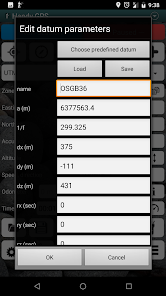
* Supports common datums such as NAD83 (US), OSGB36 (UK), NZTM2000 (NZ), SAD69 (South America) and ED50 (Europe), and you can configure your own custom datums, including local grid systems.
* UK grid refs with two letter prefixes can be shown if OSGB datum selected.
* Elevation profile.
* GPS averaging mode.
* Take photos and record voice memos, geo-located with KML files for easy viewing on a PC.
* Geo-tag photos, and/or have the coordinates and bearing "burnt" into the image.
* Sun rise and set times.
* Export data to CSV file.
* Create waypoint by triangulation, or projecting using an entered distance and bearing.
* Compute length, area, and elevation change for tracklog.
* Offline map support by downloading tiles from map tile servers, or using own map images.
* Compute calories.
* Optional background image.
* Optional location sharing on web.
* Spoken distance and direction guidance on goto page.
PERMISSIONS: (1) GPS, to show your location, (2) Network access, to load maps, (3) SD card access, to load and store waypoints, (4) Camera access, for taking pics, (5) Prevent phone from sleeping, so proximity alarm works, (6) Control flashlight, to allow flashlight use, (7) Record audio for voice memos.
DISCLAIMER: You use this app at your own risk. The developer accepts no responsibility for you getting lost or injured as a result of using this app. Batteries in mobile devices can go flat. For extended and remote hikes, a battery bank and an alternative method of navigation such as a paper map and compass are recommended for safety.
This app requires payment of an annual subscription to be fully functional. If this is not paid it will still run, but with limited functionality.
This app is a powerful navigation tool designed for outdoors sports like hiking, bushwalking, tramping, mountain biking, kayaking, boating, horse trail riding, geocaching. Its also useful for surveying, mining, archaeology, and forestry applications. Its simple to use and works even in the remotest back country since it doesn't require network connectivity. It allows you to work in UTM or lat/lon coordinates so you can even use it with your paper maps.
NOTE: Allow the app to always use GPS, and turn off battery optimisation for the app to reliably record tracklogs when the phone screen is off.
BASE FEATURES:
* Shows your current coordinates, altitude, speed, direction of travel, and distance travelled in metric, imperial/US, or nautical units.
* Can store your current location as a waypoint, and record a track log to show where you've been on a map.
* Data can be imported from and exported to KML and GPX files.
* Allows manual entry of waypoints in UTM, MGRS and lat/lon coords.
* Can guide you to a waypoint using the "Goto" screen, and optionally sound an alert when when you're getting close.
* Has a compass page which works on devices with magnetic field sensors.
* Automatically computes the local geoid offset to improve altitude accuracy
* Supports the world-wide WGS84 datum along with the common Australian datums and map grids (AGD66, AGD84, AMG, GDA94, and MGA). You can also use WGS84 for NAD83 maps in the US.
* Shows GPS satellite locations and signal strengths graphically.
* Can display simple or MGRS grid references.
* Can compute waypoint-to-waypoint distance and direction.
* Includes an optional timer line to record walk duration and compute your average speed.
* Thoroughly tested by the developer on many off-track walks
EXTRA FEATURES IN THIS VERSION:
* No ads
* Unlimited number of waypoints and track log points.
* Email or SMS your location to a friend as a clickable map link.
* Email your waypoints and tracklogs as KML or GPX file.
* Supports common datums such as NAD83 (US), OSGB36 (UK), NZTM2000 (NZ), SAD69 (South America) and ED50 (Europe), and you can configure your own custom datums, including local grid systems.
* UK grid refs with two letter prefixes can be shown if OSGB datum selected.
* Elevation profile.
* GPS averaging mode.
* Take photos and record voice memos, geo-located with KML files for easy viewing on a PC.
* Geo-tag photos, and/or have the coordinates and bearing "burnt" into the image.
* Sun rise and set times.
* Export data to CSV file.
* Create waypoint by triangulation, or projecting using an entered distance and bearing.
* Compute length, area, and elevation change for tracklog.
* Offline map support by downloading tiles from map tile servers, or using own map images.
* Compute calories.
* Optional background image.
* Optional location sharing on web.
* Spoken distance and direction guidance on goto page.
PERMISSIONS: (1) GPS, to show your location, (2) Network access, to load maps, (3) SD card access, to load and store waypoints, (4) Camera access, for taking pics, (5) Prevent phone from sleeping, so proximity alarm works, (6) Control flashlight, to allow flashlight use, (7) Record audio for voice memos.
DISCLAIMER: You use this app at your own risk. The developer accepts no responsibility for you getting lost or injured as a result of using this app. Batteries in mobile devices can go flat. For extended and remote hikes, a battery bank and an alternative method of navigation such as a paper map and compass are recommended for safety.
Updated on
Safety starts with understanding how developers collect and share your data. Data privacy and security practices may vary based on your use, region, and age. The developer provided this information and may update it over time.

This app may share these data types with third parties
Location, App activity and 2 others

No data collected
Learn more about how developers declare collection

Data is encrypted in transit

Data can’t be deleted
Ratings and reviews
4.3
968 reviews

Abdifetah Sheikmohamed
- Flag inappropriate
June 22, 2024
it's a very good app, but as a surveyor, I would would recommend you to include many other local positioning datum Coz instead of editing costum datum, it is better to have already.
2 people found this review helpful
BinaryEarth
June 22, 2024
Thanks. That could be something to add in the future, but for now we have another app called Coordinate Master which has a large built in list of coordinate systems.

A Google user
- Flag inappropriate
- Show review history
April 12, 2020
As someone who has worked in spatial industries for over 20 years and previously as a software engineer as well as an outdoorsman, I greatly appreciate this app and the effort that has gone into it! Would you consider adding geoid model support in addition to what the inbuilt receiver provides, such as AUSGEOID for use in Australia?
65 people found this review helpful
BinaryEarth
April 13, 2020
The app is already using the EGM96 geoid model to correct GPS altitudes.

Ajmer Khehra
- Flag inappropriate
June 11, 2020
Very useful app. Only issue I have is that goto waypoint screen is dark black and showing distance numbers are very small. It's very hard to read in sunny day.
41 people found this review helpful
BinaryEarth
June 11, 2020
Both are configurable. Untick the second option under the Goto section of the preferences page to use a white background, and increase the text size under the General section of the preferences page to show larger text.
What's new
42.5: Fixed crash on Android 14.
42.4: Updated to target Android SDK 34.
42.2: Updated Google Billing library.
42.1: If timer running when new session started, re-start the timer after resetting it. Fixed two bugs related to the GDA2020 datum.
42.4: Updated to target Android SDK 34.
42.2: Updated Google Billing library.
42.1: If timer running when new session started, re-start the timer after resetting it. Fixed two bugs related to the GDA2020 datum.


