
Paraglider Dashboard
৪.৬star
৯১১ টা পৰ্যালোচনা
৫০ হাজাৰ+
ডাউনল’ড

সকলো
info


এই এপ্টোৰ বিষয়ে
Paraglider Dashboard
Powerful, easy to use app especially for (powered) paragliders which can even be operated while wearing gloves (see below for details).
Paraglider Dashboard calculates wind speed and wind direction while in the air.
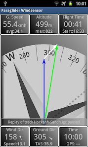
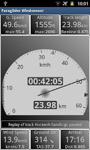
Display of wind triangle, tachometer, map with airspaces, variometer and more.
All important flight data is constantly shown in the info boxes.
Includes flight recording and logbook.
Slide through the following Views:
* Windtriangle
* Tachometer
* Map with airspaces and track
* Speed vectors (basis of wind calculation)
* Overview with all views
Always visible:
* Infoboxes with all important flight data
* GPS or pressure sensor based Variometer (optional)
Other features:
* Show past flights in a logbook
* Calculate wind triangle for different wind situations
* Set destination in map by simple long touch or select from a waypoint list
* Display of arrival time at destination taking current wind into account.
* Load airspaces in OpenAir format
* Save track as (unsigned) IGC-file
* Build-in help pages
* Simulation mode to replay IGC-files
* Metric and imperial units
* Altitude display in meter, feet or both alternating
Glove control:
With glove control switched on, you can control the app without using the touch screen (e.g. while wearing gloves).
A menu which is controlled by the proximity sensor allows this trick.
Just hovering the hand over the device lets the menu pop up and scroll through the available functions.
When releasing the hand again, the currently highlighted function is executed.
Why are the permissions needed:
* GPS Location: Now, that's obviously needed.
* Prevent from sleeping: Device should not switch off in midair.
* Internet access: Needed exclusively for Google Maps.
* USB storage: For saving IGC-files when closing app.
About the author:
I am flying a powered paraglider and developed this app tailored to my own needs. Feel free to contact me, if you have ideas for improvements or enhancements.
Powerful, easy to use app especially for (powered) paragliders which can even be operated while wearing gloves (see below for details).
Paraglider Dashboard calculates wind speed and wind direction while in the air.
Display of wind triangle, tachometer, map with airspaces, variometer and more.
All important flight data is constantly shown in the info boxes.
Includes flight recording and logbook.
Slide through the following Views:
* Windtriangle
* Tachometer
* Map with airspaces and track
* Speed vectors (basis of wind calculation)
* Overview with all views
Always visible:
* Infoboxes with all important flight data
* GPS or pressure sensor based Variometer (optional)
Other features:
* Show past flights in a logbook
* Calculate wind triangle for different wind situations
* Set destination in map by simple long touch or select from a waypoint list
* Display of arrival time at destination taking current wind into account.
* Load airspaces in OpenAir format
* Save track as (unsigned) IGC-file
* Build-in help pages
* Simulation mode to replay IGC-files
* Metric and imperial units
* Altitude display in meter, feet or both alternating
Glove control:
With glove control switched on, you can control the app without using the touch screen (e.g. while wearing gloves).
A menu which is controlled by the proximity sensor allows this trick.
Just hovering the hand over the device lets the menu pop up and scroll through the available functions.
When releasing the hand again, the currently highlighted function is executed.
Why are the permissions needed:
* GPS Location: Now, that's obviously needed.
* Prevent from sleeping: Device should not switch off in midair.
* Internet access: Needed exclusively for Google Maps.
* USB storage: For saving IGC-files when closing app.
About the author:
I am flying a powered paraglider and developed this app tailored to my own needs. Feel free to contact me, if you have ideas for improvements or enhancements.
আপডে’ট কৰা তাৰিখ
বিকাশকৰ্তাসকলে আপোনাৰ ডেটা কেনেকৈ সংগ্ৰহ আৰু শ্বেয়াৰ কৰে সেয়া বুজি পোৱাৰ জৰিয়তে সুৰক্ষা আৰম্ভ হয়। ডেটাৰ গোপনীয়তা আৰু সুৰক্ষা প্ৰণালী আপোনাৰ ব্যৱহাৰ, অঞ্চল আৰু বয়সৰ ওপৰত ভিত্তি কৰি ভিন্ন হ’ব পাৰে। বিকাশকৰ্তাগৰাকীয়ে এই তথ্যখিনি প্ৰদান কৰিছে আৰু সময়ৰ লগে লগে এয়া আপডে’ট কৰিব পাৰে।


মূল্যাংকন আৰু পৰ্যালোচনাসমূহ
৪.৬
৮৫২ টা পৰ্যালোচনা
নতুন কি আছে
Same as 2.4.0 with some bug fixes.
New in 2.4.0:
Upload of elevation data with AGL-Display.
Maintain multiple wing/pilot data sets and allow to select when saving flight.
New in 2.4.0:
Upload of elevation data with AGL-Display.
Maintain multiple wing/pilot data sets and allow to select when saving flight.
এপৰ সমৰ্থন
বিকাশকৰ্তাৰ বিষয়ে
Dr. Bolender, Edgar
edgar.bolender@googlemail.com
Meerlacher-Deich-Straße 17
68794 Oberhausen-Rheinhausen
Germany
undefined