Doppler storm radar - eMap HDF
Съдържа рекламиПокупки в прилож.
4,6star
5,69 хил. отзива

За всички възрасти
info
100 хил.+
Изтегляния


Всичко за това приложение
eMap HDF is a high-resolution predictive NOAA Doppler storm radar with a weather map.
The weather app has the next layers provided by the National Weather Service (NWS) & NOAA:
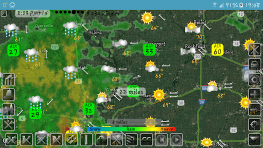
- Snow and rain radar
- Severe weather alerts, tornado tracker, heavy rain and wind alerts
- Lightning strike map
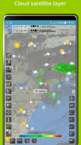
- Cloud satellite layer
Worldwide layers:
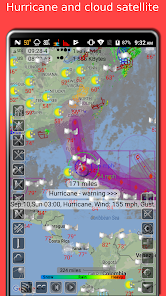
- Typhoon (tropical storm, cyclone) and hurricane tracker provided by GDACS
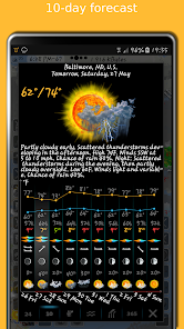
- Accurate weather forecast for 10 days
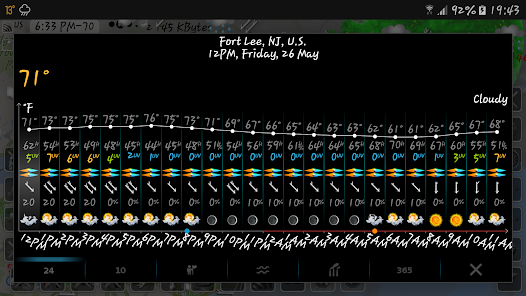
- Hourly weather forecast for 24 hours
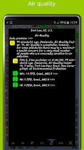
- Air quality and air pollution
- Earthquake map
- Temperature map
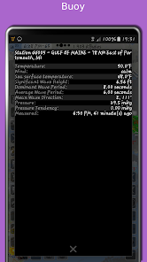
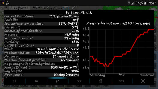
- Sea temperature based on measurements from buoys and satellites
- Tide charts
- Local time in each city
- Number of residents in cities
- Road traffic
- Buoys
- Dew point
- Humidity
- Wind map
The storm radar app calculates a one-hour prediction of rain and snow in five-minute frames. NOAA radar has a six-hour weather radar history.
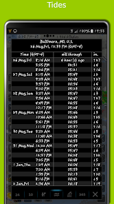
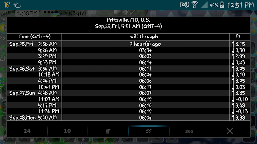
Tide times are for over 10,000 tidal stations in the US, UK, Canada, etc. with forecasts for several months. The app follows the current location and shows the tides near me.
The earthquake app includes earthquakes filtered by magnitude and depth. Earthquake tracker data is provided by the USGS.
The distance measurement tool shows the distance between two points in miles and kilometres.
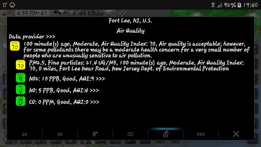
The air quality app includes concentrations of ozone (O3), fine (PM25) and coarse (PM10), particulate matter, dioxide (NO2) and nitrogen oxide (NO), carbon monoxide (CO), etc. from various sources: AirNow, Copernicus, ECMWF, etc.
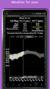
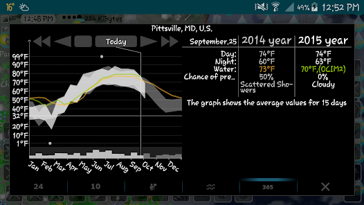
With the Doppler radar app, you can long-click on any location on the map and see the weather at that location with the archive for the last few years. The archive includes sea and air temperature, precipitation and cloud cover. Travel weather helps you choose the right time and place for your upcoming trip and compare temperatures and precipitation between this year and past years.
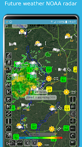
If you click on the "CC" button and toggle to "10" or "24", you can view a 10-day or 24-hour forecast directly on the map.
eMap HDF shows road traffic. The forecast includes not only temperature and precipitation, but also humidity, wind speed and direction, dew point, visibility on the roads feels like temperature.
As the data published in eMap HDF is not subject to use on the voyage, please do not use it for navigation.
The weather app has the next layers provided by the National Weather Service (NWS) & NOAA:
- Snow and rain radar
- Severe weather alerts, tornado tracker, heavy rain and wind alerts
- Lightning strike map
- Cloud satellite layer
Worldwide layers:
- Typhoon (tropical storm, cyclone) and hurricane tracker provided by GDACS
- Accurate weather forecast for 10 days
- Hourly weather forecast for 24 hours
- Air quality and air pollution
- Earthquake map
- Temperature map
- Sea temperature based on measurements from buoys and satellites
- Tide charts
- Local time in each city
- Number of residents in cities
- Road traffic
- Buoys
- Dew point
- Humidity
- Wind map
The storm radar app calculates a one-hour prediction of rain and snow in five-minute frames. NOAA radar has a six-hour weather radar history.
Tide times are for over 10,000 tidal stations in the US, UK, Canada, etc. with forecasts for several months. The app follows the current location and shows the tides near me.
The earthquake app includes earthquakes filtered by magnitude and depth. Earthquake tracker data is provided by the USGS.
The distance measurement tool shows the distance between two points in miles and kilometres.
The air quality app includes concentrations of ozone (O3), fine (PM25) and coarse (PM10), particulate matter, dioxide (NO2) and nitrogen oxide (NO), carbon monoxide (CO), etc. from various sources: AirNow, Copernicus, ECMWF, etc.
With the Doppler radar app, you can long-click on any location on the map and see the weather at that location with the archive for the last few years. The archive includes sea and air temperature, precipitation and cloud cover. Travel weather helps you choose the right time and place for your upcoming trip and compare temperatures and precipitation between this year and past years.
If you click on the "CC" button and toggle to "10" or "24", you can view a 10-day or 24-hour forecast directly on the map.
eMap HDF shows road traffic. The forecast includes not only temperature and precipitation, but also humidity, wind speed and direction, dew point, visibility on the roads feels like temperature.
As the data published in eMap HDF is not subject to use on the voyage, please do not use it for navigation.
Актуализирано на
Безопасността започва с разбирането на това как програмистите събират и споделят данните ви. Практиките за поверителност и сигурност на данните може да варират в зависимост от употребата от ваша страна, региона и възрастта ви. Тази информация е предоставена от програмиста и той може да я актуализира с течение на времето.


Оценки и отзиви
4,6
4,96 хил. отзива

Georgi Georgiev
- Подаване на сигнал за неуместност
21 декември 2021 г.
Прекрасно приложение!
BARVINENKO SERGEY VLADIMIR, IE
22 декември 2021 г.
Благодаря ти. Ще продължим да развиваме нашата метеорологична карта и да добавяме още повече данни за времето и качеството на въздуха към нея.

Stoqn Ivanov
- Подаване на сигнал за неуместност
20 март 2022 г.
Prekrasno prilozenie

Потребител на Google
- Подаване на сигнал за неуместност
6 март 2020 г.
Отлично приложение, много съм доволен,върши добра работа
BARVINENKO SERGEY VLADIMIR, IE
6 март 2020 г.
Благодаря ти. Приложението ни използва много различни услуги за времето, приливите и отливите, геомагнитните бури, качеството на въздуха, сигналите за времето, ураганите, торнадото, земетресенията, слънцето, луната, затъмненията и т.н. И ще добавим още информация.
Новите неща
Edge-to-edge display function
Some bugs fixed
User interface improved
Some bugs fixed
User interface improved
Поддръжка на приложението
Всичко за програмиста
BARVINENKO SERGEY VLADIMIR, IE
sergeybarvinenkoie@gmail.com
41, 12, 3 District
Charentsavan 2501
Armenia
+374 77 294144


