
Singapore MRT Route 新加坡地铁(Pro)
500+
Preuzimanja

Svako
info


O aplikaciji
Updated to latest Thomson-East Coast Line (TE1 Woodlands North to BayShore) to the subway system.
Exclusive Dar Mode.
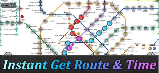
Singapore's MRT system is extending. By 2030, the MRT system will be more complex than you could image. It's good for all residents on our lovely island. But also will be a problem because we don't know how to travel the fastest when transferring stations.
Singapore MRT Map Route is designed to allows user to get the best route within a second. It will help you save a lot of time over years.
- View lastest Singapore MRT map
- Display the best route between two stations
- Automatically calculate estimated travel time
- Require no internet connection.
Updated to latest MRT system:
Downtown Line(Blue)
Bukit Panjang, Cashew, Hillview, Beauty World, King Albert Park, Sixth Avenue, Tan Kah Kee, Botanic Gardens, Stevens, Newton, Little India, Rochor, Bugis, Promenade, Bayfront, Downtown, Telok Ayer, Chinatown
Circle Line(Yellow)
Dhoby Ghaut, Bras Basah, Esplanade, Promenade, Nicoll Highway[C], Stadium, Mountbatten, Dakota, Paya Lebar, MacPherson, Tai Seng, Bartley, Serangoon, Lorong Chuan, Bishan, Marymount, Caldecott, Botanic Gardens, Farrer Road, Holland Village. Buona Vista, one-north, Kent Ridge, Haw Par Villa, Pasir Panjang, Labrador Park, Telok Blangah, HarbourFront
East West Line (Green)
Pasir Ris ,Tampines , Simei , Tanah Merah , Bedok , Kembangan , Eunos , Paya Lebar , Aljunied , Kallang , Lavender , Bugis , City Hall , Raffles Place , Tanjong Pagar , Outram Park , Tiong Bahru , Redhill , Queenstown , Commonwealth , Buona Vista , Dover ,Clementi , Jurong East , Chinese Garden , Lakeside , Boon Lay , Pioneer , Joo Koon, Expo,
Changi Airport
North South Line (Red)
Jurong East, Bukit Batok, Bukit Gombak, Choa Chu Kang, Yew Tee, Kranji, Marsiling, Woodlands, Admiralty, Sembawang, Canberra, Yishun, Khatib, Yio Chu Kang, Ang Mo Kio, Bishan, Braddell, Toa Payoh, Novena, Newton, Orchard, Somerset, Dhoby Ghaut, City Hall, Raffles Place, Marina Bay, Marina South Pier
North East Line (Purple)
HarbourFront, Outram Park, Chinatown, Clarke Quay, Dhoby Ghaut, Little India, Farrer Park, Boon Keng, Potong Pasir, Woodleigh, Serangoon, Kovan, Hougang, Buangkok, Sengkang, Punggol
Exclusive Dar Mode.
Singapore's MRT system is extending. By 2030, the MRT system will be more complex than you could image. It's good for all residents on our lovely island. But also will be a problem because we don't know how to travel the fastest when transferring stations.
Singapore MRT Map Route is designed to allows user to get the best route within a second. It will help you save a lot of time over years.
- View lastest Singapore MRT map
- Display the best route between two stations
- Automatically calculate estimated travel time
- Require no internet connection.
Updated to latest MRT system:
Downtown Line(Blue)
Bukit Panjang, Cashew, Hillview, Beauty World, King Albert Park, Sixth Avenue, Tan Kah Kee, Botanic Gardens, Stevens, Newton, Little India, Rochor, Bugis, Promenade, Bayfront, Downtown, Telok Ayer, Chinatown
Circle Line(Yellow)
Dhoby Ghaut, Bras Basah, Esplanade, Promenade, Nicoll Highway[C], Stadium, Mountbatten, Dakota, Paya Lebar, MacPherson, Tai Seng, Bartley, Serangoon, Lorong Chuan, Bishan, Marymount, Caldecott, Botanic Gardens, Farrer Road, Holland Village. Buona Vista, one-north, Kent Ridge, Haw Par Villa, Pasir Panjang, Labrador Park, Telok Blangah, HarbourFront
East West Line (Green)
Pasir Ris ,Tampines , Simei , Tanah Merah , Bedok , Kembangan , Eunos , Paya Lebar , Aljunied , Kallang , Lavender , Bugis , City Hall , Raffles Place , Tanjong Pagar , Outram Park , Tiong Bahru , Redhill , Queenstown , Commonwealth , Buona Vista , Dover ,Clementi , Jurong East , Chinese Garden , Lakeside , Boon Lay , Pioneer , Joo Koon, Expo,
Changi Airport
North South Line (Red)
Jurong East, Bukit Batok, Bukit Gombak, Choa Chu Kang, Yew Tee, Kranji, Marsiling, Woodlands, Admiralty, Sembawang, Canberra, Yishun, Khatib, Yio Chu Kang, Ang Mo Kio, Bishan, Braddell, Toa Payoh, Novena, Newton, Orchard, Somerset, Dhoby Ghaut, City Hall, Raffles Place, Marina Bay, Marina South Pier
North East Line (Purple)
HarbourFront, Outram Park, Chinatown, Clarke Quay, Dhoby Ghaut, Little India, Farrer Park, Boon Keng, Potong Pasir, Woodleigh, Serangoon, Kovan, Hougang, Buangkok, Sengkang, Punggol
Ažurirano dana
Sigurnost počinje razumijevanjem na koji način programeri prikupljaju i dijele vaše podatke. Privatnost podataka i sigurnosne prakse se mogu razlikovati ovisno o korištenju, regiji i dobi. Programer je pružio ove informacije i može ih s vremenom ažurirati.

Podaci se ne dijele s trećim stranama
Saznajte više o načinu na koji programeri pružaju izjavu o dijeljenju

Podaci se ne prikupljaju
Saznajte više o načinu na koji programeri pružaju izjavu o prikupljanju
Šta ima novo
Added Thomson-East Coast Line (Gardens by the Bay to Bayshore) to the subway system.


