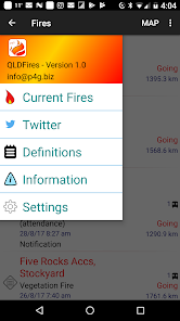
QLDFires
10 hilj.+
Preuzimanja

Svako
info
O aplikaciji
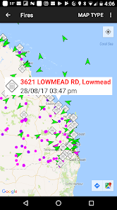
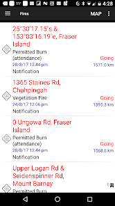
This application is designed to provide up to date information about bush fire data in Queensland, Australia for users of Android devices.
It utilises data from the Queensland Rural Fire Service data feeds on fires with your current location provided by the phone GPS.
Using this information the application is able to provide a list of fires showing the nearest ones first, helping you to understand your current situation.
The information is reliant on both the accuracy of the phone's GPS and the data recorded on the QFES's website. Please note however that this application does not represent in any way the Queensland Government.
This application does not cache any data, so Internet access (either Wireless. or 3G) is required to access the data.
Be aware that while P4G has utilised "best efforts" to provide this information to you, it is not intended to replace other sources of information on the fire situation near you. Also remember that fire and weather can change quickly.
Follow P4G on twitter at P4G_Apps
Ažurirano dana
Sigurnost počinje razumijevanjem na koji način programeri prikupljaju i dijele vaše podatke. Privatnost podataka i sigurnosne prakse se mogu razlikovati ovisno o korištenju, regiji i dobi. Programer je pružio ove informacije i može ih s vremenom ažurirati.

Podaci se ne dijele s trećim stranama
Saznajte više o načinu na koji programeri pružaju izjavu o dijeljenju

Podaci se ne prikupljaju
Saznajte više o načinu na koji programeri pružaju izjavu o prikupljanju

Podaci su šifrirani u prijenosu

Podaci se ne mogu izbrisati
Šta ima novo
We have made some optimisation changes to the way satellite data is shown and hope this fixes a number of performance issues, crashes and/or hangs in the map.


