
ok2fly
10K+
Downloads

Everyone
info


About this app
Whether you are a recreational drone pilot or a fully-fledged professional drone pilot, ok2fly™ is the drone safety tool you need for you next drone mission. ok2fly boasts the following functions:
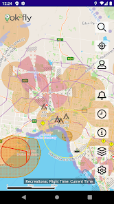
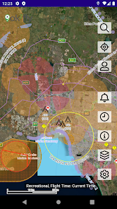
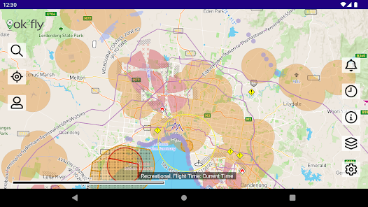
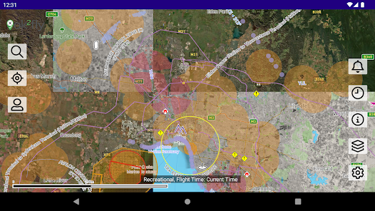
1. Detailed visualization of runway splays and airport envelopes
- Splays and envelopes are clearly displayed so the pilot can identify boundaries between airspace inside and outside of the operational areas.
2. Extended radius review of the drone flight area
- ok2fly will survey not only the location you will be flying from, but the immediate area around you
- You can configure the visual flight radius to suit your planned flight operations
3. Street level vector map of the whole of Australia
- The ok2fly vector map details standard street map information as well relevant aviation details such as obstacles, low level aviation activities and recreational sites
- You overlay further information using the Layers option*.
4. Fully implements the CASA RPAS Rules
- ok2fly is fully compliant with the CASA RPAS Safety Rules and fully integrated with the CASA RPAS Platform.
- ok2fly was the first safety app to go live as part of the CASA / Airservices Australia Airspace Authorisation trial.
5. Detailed reporting beyond the basic “yes I can” or “no I can’t fly”
- To get a more thorough understanding of the operational environment ok2fly will analyses the airspace surrounding your location
- ok2fly will provide a location report detailing all known landmarks detected in the operational airspace
6. Configure to match your drone pilot qualifications
- ok2lfy supports the 3 drone pilot types defined by the CASA safety rules, namely Recreational, Commercial Excluded* and ReOC*
- From the settings function, set the pilot type to match your qualifications*
7. Map adjusts to reflect activity at proposed flight time
- If you are flying in 1-hour, 1-day or 1-week’s time, the operational environment may be different.
- When you set the proposed time of your flight, ok2fly will reconfigure all time-based objects to reflect their status at that time.
8. Real-time activation and visualization of Restricted and Danger areas
- ok2fly maintains an activity schedule for Restricted and Danger Area airspace and uses the schedule information to depict airspace as active or inactive.
- When set to current time mode airspace activates and deactivates automatically as the time-of-day progresses
- If you select a specific flight time, ok2fly will set the state of all airspace based on that time
9. Automatic visualisation of NOTAM activities effecting drone operations
- Activities include planned drone flights, from surface to above activities such as Low Jet Routes and TRA
- Other activities such as Rocket Launches and Fireworks displays may also be included
- 4D objects are used to represent the activity and included in flight queries where they intersect geographically, vertically, and temporally
10. Continuously updated NAIPS NOTAM information
- NOTAMS for Restricted and Danger airspace are available for inspection by the drone pilot*
11. Links to supplemental decision-making information
- The Information function of ok2fly contains a selection of relevant links for drone pilots
- Links to CASA, Airservices, BOM and AvSoft Australia are included
12. Radio frequency data for FIA and airport communications
- Access supplemental airfield information for flight planning and mission communication purposes*
13. Additional aviation data to aid drone flight planning
- In addition to the standard aviation data, ok2fly maintains information on other artefacts that aid with situational awareness
- This can include Schools, Local Parks, Beaches, Embassies, Prisons, Major Roads and Rail Lines.
14. AvSoft Australia is a CASA Part 175 approved data provider
* Requires a subscription.
The term ok2fly™ is a trademark of AvSoft Australia Pty Ltd.
Updated on
Safety starts with understanding how developers collect and share your data. Data privacy and security practices may vary based on your use, region, and age. The developer provided this information and may update it over time.

No data shared with third parties
Learn more about how developers declare sharing

This app may collect these data types
Location, Personal info and 4 others

Data is encrypted in transit

You can request that data be deleted
What’s new
Performance improvements and bug fixes.
Library updates to comply with Google policies
Library updates to comply with Google policies
App support
phone
Phone number
+61383703024
About the developer
AVSOFT AUSTRALIA PTY LTD
support@avplan-efb.com
64 NORTH TCE
KENT TOWN SA 5067
Australia
+61 418 505 294