
Memory-Map
4.1star
4.63K reviews
100K+
Downloads

Everyone
info


About this app
The Memory-Map app turns your phone or tablet into a full-featured Outdoor GPS or Marine Chart Plotter, and allows you to navigate with USGS Topo maps, NOAA Marine charts, and may other specialist maps, even without a wireless internet signal.
Maps are downloaded on-the-fly and can be pre-loaded so that they can be used offline. Once the app and maps are loaded to the phone or tablet, cellular network coverage or internet connection is not required for real time GPS navigation.
The Memory-Map app can be used as a standalone GPS navigator, but it can also be used in conjunction with the Windows PC or Mac app (free download) for planning, printing and loading up maps, waypoints and routes to the phone/tablet.
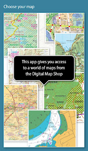
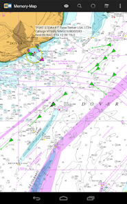
Memory-Map includes free access to 1:250,000 scale topographic maps and many other free maps around the world. More detailed maps are available for download and purchase with a free try-before-you-buy, time-limited demo option. Available maps include Ordnance Survey, Hema, USGS quads, NOAA, British Admiralty, and DeLorme. Maps can be used on your PC as well as your phone and tablet. The Cloud Sync feature allows you to keep the overlay data consistent on all your devices.
Features include:
Access a vast range of Worldwide maps and charts.
Automatically downloads a free map of your current location
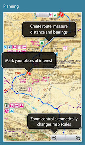
Create and edit marks and routes.
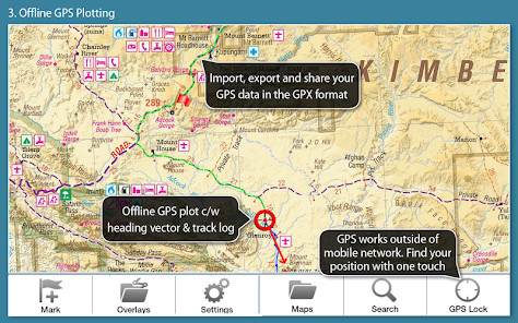
Import and export marks, routes and tracks in the open GPX format
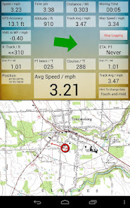
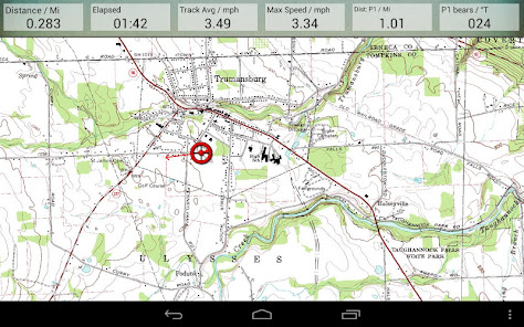
Display; Position, Course, Speed, Heading, Altitude and averages
Position coordinates include Lat/Long, UTM and GB Grid
Units displayed in Statute, Nautical or Metric
Support for GPS and Compass sensors, where available.
Placename index, can be used offline.
Moving map, lock GPS position and automatically scroll the map
Records breadcrumb trail / tracklogs.
Share position marks or tracklogs as GPX files
Proximity Alarm
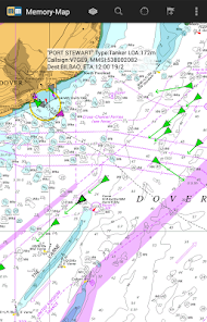
Full marine instrumentation features, with AIS, DSC and Anchor alarm
NMEA data interface via WiFi or Bluetooth
AIS collision alarm, with adjustable thresholds for Class A and Class B targets
Display Alarm notifications and Nav data on Android Wear watch
Barometer & relative altitude
Maps are downloaded on-the-fly and can be pre-loaded so that they can be used offline. Once the app and maps are loaded to the phone or tablet, cellular network coverage or internet connection is not required for real time GPS navigation.
The Memory-Map app can be used as a standalone GPS navigator, but it can also be used in conjunction with the Windows PC or Mac app (free download) for planning, printing and loading up maps, waypoints and routes to the phone/tablet.
Memory-Map includes free access to 1:250,000 scale topographic maps and many other free maps around the world. More detailed maps are available for download and purchase with a free try-before-you-buy, time-limited demo option. Available maps include Ordnance Survey, Hema, USGS quads, NOAA, British Admiralty, and DeLorme. Maps can be used on your PC as well as your phone and tablet. The Cloud Sync feature allows you to keep the overlay data consistent on all your devices.
Features include:
Access a vast range of Worldwide maps and charts.
Automatically downloads a free map of your current location
Create and edit marks and routes.
Import and export marks, routes and tracks in the open GPX format
Display; Position, Course, Speed, Heading, Altitude and averages
Position coordinates include Lat/Long, UTM and GB Grid
Units displayed in Statute, Nautical or Metric
Support for GPS and Compass sensors, where available.
Placename index, can be used offline.
Moving map, lock GPS position and automatically scroll the map
Records breadcrumb trail / tracklogs.
Share position marks or tracklogs as GPX files
Proximity Alarm
Full marine instrumentation features, with AIS, DSC and Anchor alarm
NMEA data interface via WiFi or Bluetooth
AIS collision alarm, with adjustable thresholds for Class A and Class B targets
Display Alarm notifications and Nav data on Android Wear watch
Barometer & relative altitude
Updated on
Safety starts with understanding how developers collect and share your data. Data privacy and security practices may vary based on your use, region, and age. The developer provided this information and may update it over time.

No data shared with third parties
Learn more about how developers declare sharing

This app may collect these data types
Location and Personal info

Data is encrypted in transit

You can request that data be deleted
Ratings and reviews
3.9
3.51K reviews

Paul Roberts
- Flag inappropriate
December 23, 2025
Update of review.... Any progress on a Direction-Up view? - I ask every time you ask me for a review... The view is always North-up... Any chance of a Travel-direction-up option? Memory-Map works for me - intuitive interface, easy to move around maps, scale in & out, etc. I still struggle with the Digital Map Shop - having bought maps, loading them always seems to be difficult. But once loaded, all works well.
Memory-Map, Inc.
January 18, 2026
The head-up map orientation is available in our newer app, Memory-Map for All, in the 3D Map view. See https://memory-map.com/mm-fa-help/topics/idh-topic480.htm

A Google user
- Flag inappropriate
July 18, 2021
I use the app all the time. Climbing and cycling. If you like real maps, this is for you. There are issues though, for instance the 'stay on' override doesn't work on all phones. Certainly not on the S7 active I use at the moment. Also, on a bike you need a phone that you can turn on just by pressing a button, as the maps go haywire if the screen is wet, and you therefore can't touch it, or leave it on any longer than needed. Apart from basic viewing, operation is not at all intuitive.

Paul Gredley
- Flag inappropriate
April 12, 2025
I've been using Nemory Map for years. 50,000 scale maps are great for mountain biking. Plotting routes, etc, is easy. I recently started plotting routes with the app on my phone. I used to use my laptop. While it's not as intuitive on the phone, once you've got the hang of it, it's super easy and convenient. Other apps have suggested routes, etc, which memory map doesn't do. But for route planning, I can't fault it.
What’s new
Tap a track to select/edit
Find time, speed and altitude at any point on a track
Split/Join tracks
Split/Join routes
Added line styles (dash, dot, etc) for tracks and routes
Scoped Storage for Data Layout files and GPX data.
Display maps storage by folder
Delete all maps by type or folder
Find time, speed and altitude at any point on a track
Split/Join tracks
Split/Join routes
Added line styles (dash, dot, etc) for tracks and routes
Scoped Storage for Data Layout files and GPX data.
Display maps storage by folder
Delete all maps by type or folder
App support
About the developer
MEMORY-MAP, INC.
support@memory-map.com
51 Elm St
Trumansburg, NY 14886-9729
United States
+1 607-216-9195


