GPS Coordinates
Contains adsIn-app purchases
100K+
Downloads

Everyone
info


About this app
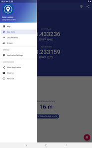
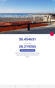
Use this application to find the coordinates of your location using your device GPS, and store them taking a photo of your spot if needed.
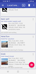
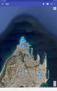
Keep track of all visited locations and show them on map all together or by a group, with details like name, description, address, date, altitude, location and coordinates with respective photo if taken.
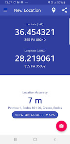
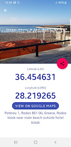
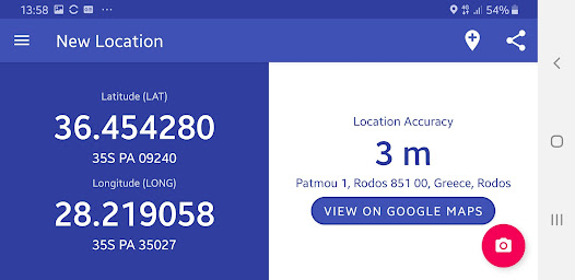
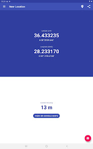
Coordinates are displayed with a basic format in decimal degrees (DD) and an auxiliary format which can be changed in application settings and is one of the following:
🌕 GPS Coordinates in Degrees, Minutes, Seconds (DMS)
🌕 GPS Coordinates in Degrees, Decimal Minutes (DDM)
🌕 GPS Coordinates in Universal Transverse Mercator (UTM)
🌕 GPS Coordinates in Military Grid Reference System (MGRS)
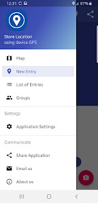
Basic Application Features:
⚫ Export stored location list with coordinates and photo to the popular formats KML, GPX and PDF
⚫ Backup stored location with all kind of data included (photo , name, description, notes, value, date, coordinates , group etc.) to the zipped file fundroid.zip, which is also shareable to others.
⚫ Restore every stored location with coordinates and photo from the zipped file fundroid.zip
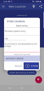
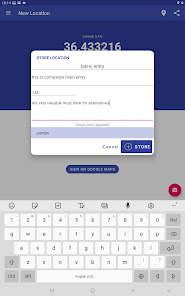
⚫ Save additional information like title, coordinates , description, notes, photo , value and group among with the location. You can choose this kind of information in application settings.
⚫ Create groups for better location categorization and grouping.
⚫ Share location with coordinates and respective photo if exist, via email and other methods.
⚫ View every stored location with coordinates and photo or location of a specific group on the map
⚫ Show location with coordinates and photo on Google Maps.
⚫ Store location, with or without photo , by selecting a spot on the map
⚫ Stamp the photo taken with location coordinates and date. Enable of disable this capability in application settings.
⚫ Measure and Store Distance and Area on map
Coordinates and rest data are correlated to WGS84.
Have in mind that signal accuracy depends mainly on your GPS sensor quality and on outside weather conditions. So, try to use this application outside most of the time.
Keep track of all visited locations and show them on map all together or by a group, with details like name, description, address, date, altitude, location and coordinates with respective photo if taken.
Coordinates are displayed with a basic format in decimal degrees (DD) and an auxiliary format which can be changed in application settings and is one of the following:
🌕 GPS Coordinates in Degrees, Minutes, Seconds (DMS)
🌕 GPS Coordinates in Degrees, Decimal Minutes (DDM)
🌕 GPS Coordinates in Universal Transverse Mercator (UTM)
🌕 GPS Coordinates in Military Grid Reference System (MGRS)
Basic Application Features:
⚫ Export stored location list with coordinates and photo to the popular formats KML, GPX and PDF
⚫ Backup stored location with all kind of data included (photo , name, description, notes, value, date, coordinates , group etc.) to the zipped file fundroid.zip, which is also shareable to others.
⚫ Restore every stored location with coordinates and photo from the zipped file fundroid.zip
⚫ Save additional information like title, coordinates , description, notes, photo , value and group among with the location. You can choose this kind of information in application settings.
⚫ Create groups for better location categorization and grouping.
⚫ Share location with coordinates and respective photo if exist, via email and other methods.
⚫ View every stored location with coordinates and photo or location of a specific group on the map
⚫ Show location with coordinates and photo on Google Maps.
⚫ Store location, with or without photo , by selecting a spot on the map
⚫ Stamp the photo taken with location coordinates and date. Enable of disable this capability in application settings.
⚫ Measure and Store Distance and Area on map
Coordinates and rest data are correlated to WGS84.
Have in mind that signal accuracy depends mainly on your GPS sensor quality and on outside weather conditions. So, try to use this application outside most of the time.
Updated on
Safety starts with understanding how developers collect and share your data. Data privacy and security practices may vary based on your use, region, and age. The developer provided this information and may update it over time.


What’s new
1. Capture multiple photos per location.
2. Stamp each photo with location name.
3. Adjustment – Correct the location's coordinates by simply long-pressing each marker and dragging it to the desired location.
2. Stamp each photo with location name.
3. Adjustment – Correct the location's coordinates by simply long-pressing each marker and dragging it to the desired location.
App support
phone
Phone number
+306937746644
About the developer
NIKOLAOS GKOUMOTSIOS
ngoumotsios@gmail.com
46 LONDINOU ST.
RHODES 85100
Greece
undefined


