
渋滞情報ならATIS(アティス)
100K+
Downloads

Everyone
info
About this app
-------------------------------
Traffic Information App Supported by Professional Drivers
-------------------------------
This app provides detailed, timely information on nationwide expressways and local roads, and shows traffic congestion times!
◆ATIS Traffic Information Features
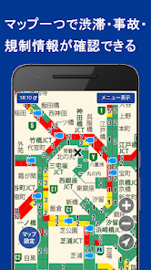
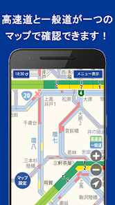
- Easy-to-Read Traffic Congestion Map
Simply select the area you want to view and see the latest road information at a glance.
Easily check congested sections, accidents, and traffic restrictions on the map, making detours clear at a glance!
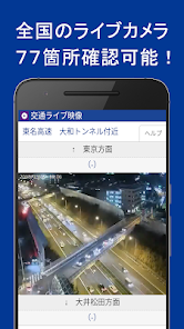
- Live camera footage shows traffic flow at a glance.
Check traffic congestion at passing points with video!
-------------------------------
List of Menus Available in This App
-------------------------------
◆Paid Menu
・Wide Area Map (Expressways + Local Roads)
・Area Map (Detailed Map)
・Speed Speed Camera Information
・Congestion Text Information
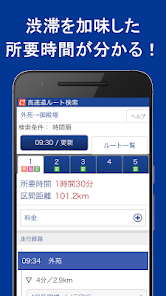
・Expressway Route Search
・Live Traffic Footage
・Traffic Information Push Notifications/Email Notifications
Other convenient features are also available.
・Parking and facility search
・Roadside station information
・Transportation news
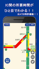
・ATIS's unique map provides detailed information on traffic congestion by IC section.
- Get a bird's-eye view of overall traffic congestion and identify detour points at a glance.
- Simply click the "X" icon on the map to receive detailed information on traffic restrictions.
- Includes the "Accident Information Start Time" provided by the Japan Road Traffic Information Center.
- GPS functionality allows you to display traffic information around your current location with one touch.
- Displays information on over 200 speed camera locations nationwide.
*Voice guidance is also available for expressways only.
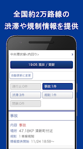
- All maps and text information are automatically updated every 55 seconds. Always display the latest information while traveling.
- Covers approximately 20,000 routes nationwide.
- Check traffic restrictions such as accidents and road closures, traffic congestion, travel times between interchanges, and connection information to other routes in an easy-to-read format.
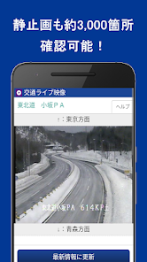
- Check traffic flow at passing points with live video
With live cameras (video) installed in approximately 70 locations mainly in the Tokyo metropolitan area and still images of approximately 2,600 road locations nationwide provided by JARTIC (locations change throughout the year),
you can keep track of traffic flow, weather, and road conditions.
- Best route guidance based on the latest traffic information
Guides you to the fastest and best highway route, taking into account congestion and road restrictions updated every five minutes.
- Simple dashcam
Adds dashcam functionality. Easy to use, with no complicated settings required.
Just tap the switch and you're ready to go.
- Latest information notification function
Receive email or push notifications to be notified of accidents, road closures, and congestion on your frequently used routes.
◆Free Menu
・Traffic Congestion Forecast
・Expressway Opening Information
・SAPA Information
・ETC Discount Guide
・Weather Information
-------------------------------
Compatible Devices/OS
-------------------------------
Compatible with Android 6.0 or higher smartphones and Android 6.0 or higher tablet devices.
*Please note that operation may be limited depending on the OS version.
-------------------------------
Information Fee
-------------------------------
・All-you-can-use Deluxe Course (¥350/month, excluding tax)
・Basic Course (¥200/month, excluding tax) with access to some menus, including simple maps and text information
-------------------------------
Payment Methods
-------------------------------
Docomo sp mode payment, au Easy Payment, SoftBank One-Touch Payment, Credit Card Payment
(Updated as of September 18, 2020)
Traffic Information App Supported by Professional Drivers
-------------------------------
This app provides detailed, timely information on nationwide expressways and local roads, and shows traffic congestion times!
◆ATIS Traffic Information Features
- Easy-to-Read Traffic Congestion Map
Simply select the area you want to view and see the latest road information at a glance.
Easily check congested sections, accidents, and traffic restrictions on the map, making detours clear at a glance!
- Live camera footage shows traffic flow at a glance.
Check traffic congestion at passing points with video!
-------------------------------
List of Menus Available in This App
-------------------------------
◆Paid Menu
・Wide Area Map (Expressways + Local Roads)
・Area Map (Detailed Map)
・Speed Speed Camera Information
・Congestion Text Information
・Expressway Route Search
・Live Traffic Footage
・Traffic Information Push Notifications/Email Notifications
Other convenient features are also available.
・Parking and facility search
・Roadside station information
・Transportation news
・ATIS's unique map provides detailed information on traffic congestion by IC section.
- Get a bird's-eye view of overall traffic congestion and identify detour points at a glance.
- Simply click the "X" icon on the map to receive detailed information on traffic restrictions.
- Includes the "Accident Information Start Time" provided by the Japan Road Traffic Information Center.
- GPS functionality allows you to display traffic information around your current location with one touch.
- Displays information on over 200 speed camera locations nationwide.
*Voice guidance is also available for expressways only.
- All maps and text information are automatically updated every 55 seconds. Always display the latest information while traveling.
- Covers approximately 20,000 routes nationwide.
- Check traffic restrictions such as accidents and road closures, traffic congestion, travel times between interchanges, and connection information to other routes in an easy-to-read format.
- Check traffic flow at passing points with live video
With live cameras (video) installed in approximately 70 locations mainly in the Tokyo metropolitan area and still images of approximately 2,600 road locations nationwide provided by JARTIC (locations change throughout the year),
you can keep track of traffic flow, weather, and road conditions.
- Best route guidance based on the latest traffic information
Guides you to the fastest and best highway route, taking into account congestion and road restrictions updated every five minutes.
- Simple dashcam
Adds dashcam functionality. Easy to use, with no complicated settings required.
Just tap the switch and you're ready to go.
- Latest information notification function
Receive email or push notifications to be notified of accidents, road closures, and congestion on your frequently used routes.
◆Free Menu
・Traffic Congestion Forecast
・Expressway Opening Information
・SAPA Information
・ETC Discount Guide
・Weather Information
-------------------------------
Compatible Devices/OS
-------------------------------
Compatible with Android 6.0 or higher smartphones and Android 6.0 or higher tablet devices.
*Please note that operation may be limited depending on the OS version.
-------------------------------
Information Fee
-------------------------------
・All-you-can-use Deluxe Course (¥350/month, excluding tax)
・Basic Course (¥200/month, excluding tax) with access to some menus, including simple maps and text information
-------------------------------
Payment Methods
-------------------------------
Docomo sp mode payment, au Easy Payment, SoftBank One-Touch Payment, Credit Card Payment
(Updated as of September 18, 2020)
Updated on
Safety starts with understanding how developers collect and share your data. Data privacy and security practices may vary based on your use, region, and age. The developer provided this information and may update it over time.

No data shared with third parties
Learn more about how developers declare sharing

This app may collect these data types
Personal info, App activity, and Device or other IDs

Data is encrypted in transit

Data can’t be deleted
What’s new
アイコンを変更しました。
App support
About the developer
NIHON ENTERPRISE CO., LTD.
content-atis@nihon-e.co.jp
1-17-8, SHIBUYA
MATSUOKASHIBUYA BLDG.
SHIBUYA-KU, 東京都 150-0002
Japan
+81 3-6434-0880