ライフレンジャーナビ |渋滞情報や抜け道も分かる音声カーナビ
1K+
Downloads

Everyone
info
About this app
■ List of main functions
(1) Map display [Free]
- Enlarged display of points to avoid trouble while walking on the road, such as station exit numbers and intersections. Click on the map to quickly find out how long it will take to walk or bike to your destination!
・The map data is the MAPPLE road data that is well-received by "Super Mapple" and is precisely reproduced on the smartphone app, and the 3D icon display makes it easy to understand your current location and route to your destination!
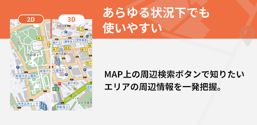
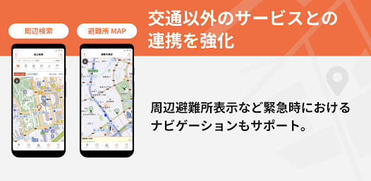
(2) MAP surrounding search [Free]
・You can search for a variety of spots near your current location, such as stations, bus stops, convenience stores, and restaurants, all at once by narrowing down your search using any genre or free word!
(3) Evacuation center map [Free]
・Even in the event of a disaster, you can quickly obtain information and reach the evacuation center without panic, such as checking nearby evacuation shelters, searching for routes, and navigating the route to your home!
---- The following can be used after paid registration ----
(4) Map display of congestion/traffic information
・Display real-time VICS traffic congestion information and regulation information on a map for easy viewing
Information updated at 1 minute intervals in the Shuto Expressway area
(5) Destination search
・Free word search, vague search, and search by address, phone number, and postal code
・You can search for spots near your current location or any location in a variety of genres.
(6) Transfer information
・Display of the boarding platform number and the most suitable vehicle for your next transfer
・Search for routes that are cheap to arrive, take short time, have low fares, and have few transfers at once.
・Supports transfer search for the previous and next train
・Supports various condition settings such as whether to use paid express trains, express buses, or airplanes.
(7) Railway/bus timetable
・Search timetables for stations/bus stops nationwide
・Supports time display at passing stations and bus stops on the way
・You can search for the nearest station/bus stop from your current location with one touch.
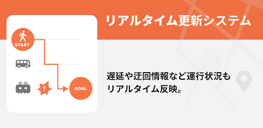
(8) Operation information
・Display real-time nationwide railway operation information and route maps
・You can instantly check not only delays, suspensions, and suspension of operations, but also recovery information.
(9) Route search
・You can search for walking, walking + train & bus, and car routes.
・For walking + train & bus routes, you can search for the optimal route door-to-door.
・Up to 5 car routes can be listed and searchable.
・You can check the details of the driving route in a list, and also support driving simulation with demo driving on the map.
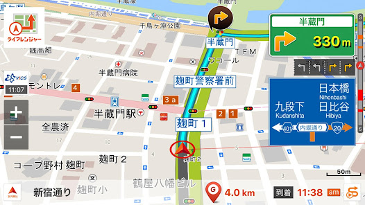
(10) Car navigation system
・Supports reading of intersection names and voice guidance for going straight and turning left and right
- Illustrated display of toll road entrances, highway junctions, etc.
・Display direction signs and driving lane information for general roads
・Supports auto-reroute function that takes into account real-time traffic jams and regulatory information (displays re-route while driving considering traffic jams)
・Supports alerts for Orbis points with audio and icon display on the map
■Supported OS
AndroidOS 10.0 or higher (AndroidOS 11.0 or higher recommended)
■Compatible terminals
Please note that the navigation function will not work properly on devices that are not equipped with GPS.
■Notes
-The information provided in this app may differ from the actual information. Please use the app as reference information.
・When using the navigation function, please drive according to the actual road conditions and traffic rules.
- Operating the app while moving may lead to an accident. Please be sure to stop in a safe place before operating the vehicle, or have a passenger operate the vehicle.
・We are not responsible for any accidents or business-related damages caused by using this app.
・Even if registered information is lost due to a failure, our company cannot be held responsible in any way.
・GPS reception may not be possible or accurate location may not be determined depending on the location, such as inside buildings or tunnels.
・During navigation, positioning continues even in the background. In this case, the battery consumption may be higher than usual, so we recommend that you use it in a state where it is fully charged or can be constantly powered by a cigarette lighter power source.
(1) Map display [Free]
- Enlarged display of points to avoid trouble while walking on the road, such as station exit numbers and intersections. Click on the map to quickly find out how long it will take to walk or bike to your destination!
・The map data is the MAPPLE road data that is well-received by "Super Mapple" and is precisely reproduced on the smartphone app, and the 3D icon display makes it easy to understand your current location and route to your destination!
(2) MAP surrounding search [Free]
・You can search for a variety of spots near your current location, such as stations, bus stops, convenience stores, and restaurants, all at once by narrowing down your search using any genre or free word!
(3) Evacuation center map [Free]
・Even in the event of a disaster, you can quickly obtain information and reach the evacuation center without panic, such as checking nearby evacuation shelters, searching for routes, and navigating the route to your home!
---- The following can be used after paid registration ----
(4) Map display of congestion/traffic information
・Display real-time VICS traffic congestion information and regulation information on a map for easy viewing
Information updated at 1 minute intervals in the Shuto Expressway area
(5) Destination search
・Free word search, vague search, and search by address, phone number, and postal code
・You can search for spots near your current location or any location in a variety of genres.
(6) Transfer information
・Display of the boarding platform number and the most suitable vehicle for your next transfer
・Search for routes that are cheap to arrive, take short time, have low fares, and have few transfers at once.
・Supports transfer search for the previous and next train
・Supports various condition settings such as whether to use paid express trains, express buses, or airplanes.
(7) Railway/bus timetable
・Search timetables for stations/bus stops nationwide
・Supports time display at passing stations and bus stops on the way
・You can search for the nearest station/bus stop from your current location with one touch.
(8) Operation information
・Display real-time nationwide railway operation information and route maps
・You can instantly check not only delays, suspensions, and suspension of operations, but also recovery information.
(9) Route search
・You can search for walking, walking + train & bus, and car routes.
・For walking + train & bus routes, you can search for the optimal route door-to-door.
・Up to 5 car routes can be listed and searchable.
・You can check the details of the driving route in a list, and also support driving simulation with demo driving on the map.
(10) Car navigation system
・Supports reading of intersection names and voice guidance for going straight and turning left and right
- Illustrated display of toll road entrances, highway junctions, etc.
・Display direction signs and driving lane information for general roads
・Supports auto-reroute function that takes into account real-time traffic jams and regulatory information (displays re-route while driving considering traffic jams)
・Supports alerts for Orbis points with audio and icon display on the map
■Supported OS
AndroidOS 10.0 or higher (AndroidOS 11.0 or higher recommended)
■Compatible terminals
Please note that the navigation function will not work properly on devices that are not equipped with GPS.
■Notes
-The information provided in this app may differ from the actual information. Please use the app as reference information.
・When using the navigation function, please drive according to the actual road conditions and traffic rules.
- Operating the app while moving may lead to an accident. Please be sure to stop in a safe place before operating the vehicle, or have a passenger operate the vehicle.
・We are not responsible for any accidents or business-related damages caused by using this app.
・Even if registered information is lost due to a failure, our company cannot be held responsible in any way.
・GPS reception may not be possible or accurate location may not be determined depending on the location, such as inside buildings or tunnels.
・During navigation, positioning continues even in the background. In this case, the battery consumption may be higher than usual, so we recommend that you use it in a state where it is fully charged or can be constantly powered by a cigarette lighter power source.
Updated on
Safety starts with understanding how developers collect and share your data. Data privacy and security practices may vary based on your use, region, and age. The developer provided this information and may update it over time.

This app may share these data types with third parties
Location and Personal info

No data collected
Learn more about how developers declare collection

Data isn’t encrypted


