new pec smart ~航海支援アプリ~
In-app purchases
10K+
Downloads

Everyone
info


About this app
[Note]
"new pec smart" is for Android 10, models with 4GB or more RAM and GPS.
・It may not work properly on devices with less than 4GB RAM.
・Please use it on a device with a GPS sensor (capable of obtaining information from GPS satellites).
[Important! Please read!]
"new pec smart" displays a huge amount of map data, so it may not work properly even on compatible OS and models.
We offer a 30-day free trial period for initial registration, so please check the operation during the trial period and be sure to cancel your subscription if it does not work properly.
*Please note that uninstalling the app does not cancel your subscription.
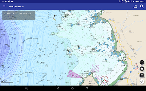
■What kind of app is "new pec smart"?
"new pec smart" is a full-fledged navigation support app that is fully equipped with "new pec (★)" data and has been approved as a legal equipment (alternative to nautical charts) for small coastal vessels.
It is equipped with weather and ocean forecasts necessary for safe navigation, as well as navigation planning, navigation records (saving GPS logs), and My Point registration.
In addition, it is equipped with AIS (Automatic Identification System) display function and "Port Guide for Pleasure Boats and Small Ships (S Guide)", supporting navigation of a wide range of ships from small to large. .
The app itself is free to download, and the first 30 days are free for the first registration, so please try it out.
★"new pec" is an "electronic navigational reference chart" issued by the Japan Hydrographic Association (a foundation) and designated by the Ministry of Land, Infrastructure, Transport and Tourism as a substitute for nautical charts that small ships navigating the coast should have.
For more information about "new pec", please visit https://newpec.jp/.
■Main features and functions of "new pec smart"
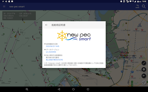
○Approved as a legal equipment for small coastal ships! In June 2020, the "new pec smart/Android version" was approved by the Japan Craft Inspection Organization (JCI) as a legal equipment (alternative to nautical charts) for small coastal vessels (※).
This means that "new pec smart" can be used in place of a "nautical chart."
※If "new pec smart" is used as legal equipment, a special inspection by JCI may be required.
※To use the "ship inspection certificate" as legal equipment, you will need to purchase a monthly subscription ticket.
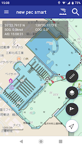
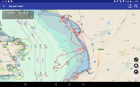
○Includes detailed data (nationwide edition) unique to "new pec"!
・Unlimited use of detailed "new pec" national version and seabed topography maps
・Displays 2m/5m/10m safety contours
・Displays fishing gear and fixed nets
・Displays sea routes, navigation aids, coastal lighthouses, etc.
・Full information on marinas and fishing ports
・Includes "tides (approx. 850 locations nationwide)" and "currents"
・"new pec" data is updated four times a year (January, April, July, October)
*To use some functions such as "detailed maps", "seabed topography", "tides", "currents" and "spot search", you will need to purchase a monthly subscription ticket.
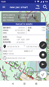
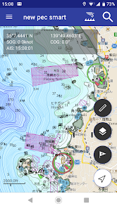
○Equipped with AIS (Automatic Identification System) display function!
・Equipped with AIS display function, which is mandatory for large ships
・Highly reliable information provided by Toyo Signal Communication Co., Ltd., which operates "shipfinder.com"
*To use the "AIS" function, you will need to purchase a monthly subscription ticket.
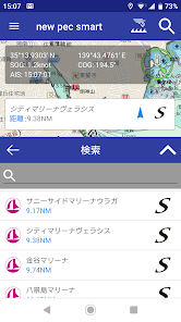
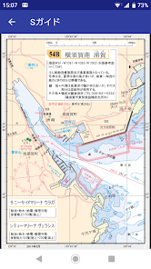
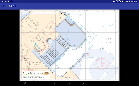
○ Equipped with "Port Guide for Pleasure Boats and Small Ships (S Guide)"!
・"S Guide" has been designated by the Ministry of Land, Infrastructure, Transport and Tourism as a substitute for nautical charts that small ships sailing along the coast should have (※)
・ Contains over 1,100 charts published and sold by the Japan Hydrographic Association for 109 areas nationwide (1,620 yen per area)
・ Along with the four yearly updates of "new pec" data, the latest version of "S Guide" is also provided
※ To use the "S Guide" function, you will need to purchase a monthly subscription ticket.
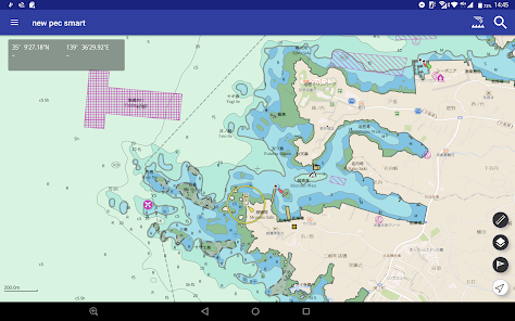
○ Seamless and smooth operation!
・ Seamless and smooth operation across the country like a map app
Easy operation with swiping and pinching in and out
○ Register your favorite places and dangerous spots you have discovered in "My Points"!
・Register points where you have caught a good catch
・Registered points can be easily managed by changing the icon and color
・My points can be shared with friends
○"New pec" information is updated four times a year!
・We respond to updates and releases of "New pec" that are released four times a year faster than anyone else
・Update times: January, April, July, October
・Other updates of high urgency are carried out in a timely manner
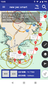
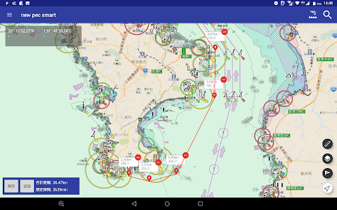
○Register and manage navigation plans and navigation records (GPS logs)!
・Create a navigation plan at home before sailing
・The created plan can be shared with friends
・Save the navigation track (GPS log) during the voyage
・Saved navigation records can also be shared with friends
○"Tides" and "currents" necessary for safe navigation
・Graphs of tidal information for approximately 850 points in Japan
・"Current" information for major areas is displayed on a map
*To use "tides" and "currents", you will need to purchase a monthly subscription ticket.
○Reliable "backup function"!
-You can back up your points, navigation plans, and navigation records.
-You can rest assured even if you change your model or have a device malfunction.
○Abundant forecast information unique to smartphone apps!
-Wind speed and direction
-Wave height, wave direction, wave period
-Sea surface temperature
-Pinpoint weather by latitude and longitude (1-hour forecast and weekly weather)
(If the latitude and longitude is at sea, the weekly weather will be displayed up to 3 days in advance.)
*To use the "weather and ocean forecast", you will need to purchase a monthly subscription ticket.
■Subscription fee
Monthly fee of 960 yen (tax included)
You can try the initial registration for free for 30 days.
*After the free period, you will be automatically charged, but if you "cancel" within the free period, no charge will be incurred.
*Subscription fees are subject to change, so please be sure to check the purchase screen before registering.
■About the "new pec smart" monthly subscription ticket (960 yen/month)
・Payment after purchase will be charged to your Google account.
・Monthly tickets use the Auto Renewable Subscription function.
・Charges for automatic renewal will be made from 24 hours before the end of the valid period until the end of the valid period.
・Once your Google account is charged, you will be able to use all of the features of "new pec smart".
・You can cancel or change the settings for automatic renewal charges from the subscription page on the Play Store.
・You can stop (cancel) automatic renewal by selecting our service "new pec smart" from the "Subscription" above and selecting "Cancel subscription" more than 24 hours before the end of the valid period.
■Supported OS and models
・This app is compatible with Android 10, models with 4GB or more RAM and GPS.
※Please note that models other than those listed above (such as Android 9 or lower and models without GPS) are not supported.
※Even if the device is Android 10 or higher, it may not work properly on older models.
*Not compatible with customized Android-based OS (Fire OS, Chrome OS, HyperOS, etc.)
*The app cannot be used on models without GPS.
*Please note that GPS performance varies greatly depending on the model and OS.
*It may not work properly on models with less than 4GB of RAM. We recommend using models with 4GB of RAM or more.
Android devices are available from many manufacturers both in Japan and abroad with various specifications, but some devices may not work properly even with the target specifications.
In particular, we may not be able to check the specifications of tablets made overseas, so please note that we may not be able to respond if a problem occurs.
■Caution
-This app is not a nautical chart. Please use the nautical chart to make decisions regarding the safety of navigation.
-Please use the app in accordance with actual laws and regulations and the rules of the surrounding fishery associations, etc.
-Please pay close attention to safety, such as weather, sea conditions, and surrounding conditions.
-This app consumes a lot of battery, so be sure to bring a spare battery, etc.・We are not responsible for any trouble, accidents, or distress that may occur from using this app.
*When using online, the latest files of maps, etc. will be downloaded as necessary. If you want to reduce data usage, please download the maps in advance in a WiFi environment and use the app offline.
"new pec smart" is for Android 10, models with 4GB or more RAM and GPS.
・It may not work properly on devices with less than 4GB RAM.
・Please use it on a device with a GPS sensor (capable of obtaining information from GPS satellites).
[Important! Please read!]
"new pec smart" displays a huge amount of map data, so it may not work properly even on compatible OS and models.
We offer a 30-day free trial period for initial registration, so please check the operation during the trial period and be sure to cancel your subscription if it does not work properly.
*Please note that uninstalling the app does not cancel your subscription.
■What kind of app is "new pec smart"?
"new pec smart" is a full-fledged navigation support app that is fully equipped with "new pec (★)" data and has been approved as a legal equipment (alternative to nautical charts) for small coastal vessels.
It is equipped with weather and ocean forecasts necessary for safe navigation, as well as navigation planning, navigation records (saving GPS logs), and My Point registration.
In addition, it is equipped with AIS (Automatic Identification System) display function and "Port Guide for Pleasure Boats and Small Ships (S Guide)", supporting navigation of a wide range of ships from small to large. .
The app itself is free to download, and the first 30 days are free for the first registration, so please try it out.
★"new pec" is an "electronic navigational reference chart" issued by the Japan Hydrographic Association (a foundation) and designated by the Ministry of Land, Infrastructure, Transport and Tourism as a substitute for nautical charts that small ships navigating the coast should have.
For more information about "new pec", please visit https://newpec.jp/.
■Main features and functions of "new pec smart"
○Approved as a legal equipment for small coastal ships! In June 2020, the "new pec smart/Android version" was approved by the Japan Craft Inspection Organization (JCI) as a legal equipment (alternative to nautical charts) for small coastal vessels (※).
This means that "new pec smart" can be used in place of a "nautical chart."
※If "new pec smart" is used as legal equipment, a special inspection by JCI may be required.
※To use the "ship inspection certificate" as legal equipment, you will need to purchase a monthly subscription ticket.
○Includes detailed data (nationwide edition) unique to "new pec"!
・Unlimited use of detailed "new pec" national version and seabed topography maps
・Displays 2m/5m/10m safety contours
・Displays fishing gear and fixed nets
・Displays sea routes, navigation aids, coastal lighthouses, etc.
・Full information on marinas and fishing ports
・Includes "tides (approx. 850 locations nationwide)" and "currents"
・"new pec" data is updated four times a year (January, April, July, October)
*To use some functions such as "detailed maps", "seabed topography", "tides", "currents" and "spot search", you will need to purchase a monthly subscription ticket.
○Equipped with AIS (Automatic Identification System) display function!
・Equipped with AIS display function, which is mandatory for large ships
・Highly reliable information provided by Toyo Signal Communication Co., Ltd., which operates "shipfinder.com"
*To use the "AIS" function, you will need to purchase a monthly subscription ticket.
○ Equipped with "Port Guide for Pleasure Boats and Small Ships (S Guide)"!
・"S Guide" has been designated by the Ministry of Land, Infrastructure, Transport and Tourism as a substitute for nautical charts that small ships sailing along the coast should have (※)
・ Contains over 1,100 charts published and sold by the Japan Hydrographic Association for 109 areas nationwide (1,620 yen per area)
・ Along with the four yearly updates of "new pec" data, the latest version of "S Guide" is also provided
※ To use the "S Guide" function, you will need to purchase a monthly subscription ticket.
○ Seamless and smooth operation!
・ Seamless and smooth operation across the country like a map app
Easy operation with swiping and pinching in and out
○ Register your favorite places and dangerous spots you have discovered in "My Points"!
・Register points where you have caught a good catch
・Registered points can be easily managed by changing the icon and color
・My points can be shared with friends
○"New pec" information is updated four times a year!
・We respond to updates and releases of "New pec" that are released four times a year faster than anyone else
・Update times: January, April, July, October
・Other updates of high urgency are carried out in a timely manner
○Register and manage navigation plans and navigation records (GPS logs)!
・Create a navigation plan at home before sailing
・The created plan can be shared with friends
・Save the navigation track (GPS log) during the voyage
・Saved navigation records can also be shared with friends
○"Tides" and "currents" necessary for safe navigation
・Graphs of tidal information for approximately 850 points in Japan
・"Current" information for major areas is displayed on a map
*To use "tides" and "currents", you will need to purchase a monthly subscription ticket.
○Reliable "backup function"!
-You can back up your points, navigation plans, and navigation records.
-You can rest assured even if you change your model or have a device malfunction.
○Abundant forecast information unique to smartphone apps!
-Wind speed and direction
-Wave height, wave direction, wave period
-Sea surface temperature
-Pinpoint weather by latitude and longitude (1-hour forecast and weekly weather)
(If the latitude and longitude is at sea, the weekly weather will be displayed up to 3 days in advance.)
*To use the "weather and ocean forecast", you will need to purchase a monthly subscription ticket.
■Subscription fee
Monthly fee of 960 yen (tax included)
You can try the initial registration for free for 30 days.
*After the free period, you will be automatically charged, but if you "cancel" within the free period, no charge will be incurred.
*Subscription fees are subject to change, so please be sure to check the purchase screen before registering.
■About the "new pec smart" monthly subscription ticket (960 yen/month)
・Payment after purchase will be charged to your Google account.
・Monthly tickets use the Auto Renewable Subscription function.
・Charges for automatic renewal will be made from 24 hours before the end of the valid period until the end of the valid period.
・Once your Google account is charged, you will be able to use all of the features of "new pec smart".
・You can cancel or change the settings for automatic renewal charges from the subscription page on the Play Store.
・You can stop (cancel) automatic renewal by selecting our service "new pec smart" from the "Subscription" above and selecting "Cancel subscription" more than 24 hours before the end of the valid period.
■Supported OS and models
・This app is compatible with Android 10, models with 4GB or more RAM and GPS.
※Please note that models other than those listed above (such as Android 9 or lower and models without GPS) are not supported.
※Even if the device is Android 10 or higher, it may not work properly on older models.
*Not compatible with customized Android-based OS (Fire OS, Chrome OS, HyperOS, etc.)
*The app cannot be used on models without GPS.
*Please note that GPS performance varies greatly depending on the model and OS.
*It may not work properly on models with less than 4GB of RAM. We recommend using models with 4GB of RAM or more.
Android devices are available from many manufacturers both in Japan and abroad with various specifications, but some devices may not work properly even with the target specifications.
In particular, we may not be able to check the specifications of tablets made overseas, so please note that we may not be able to respond if a problem occurs.
■Caution
-This app is not a nautical chart. Please use the nautical chart to make decisions regarding the safety of navigation.
-Please use the app in accordance with actual laws and regulations and the rules of the surrounding fishery associations, etc.
-Please pay close attention to safety, such as weather, sea conditions, and surrounding conditions.
-This app consumes a lot of battery, so be sure to bring a spare battery, etc.・We are not responsible for any trouble, accidents, or distress that may occur from using this app.
*When using online, the latest files of maps, etc. will be downloaded as necessary. If you want to reduce data usage, please download the maps in advance in a WiFi environment and use the app offline.
Updated on
Safety starts with understanding how developers collect and share your data. Data privacy and security practices may vary based on your use, region, and age. The developer provided this information and may update it over time.


What’s new
偏差の値を調整
App support
About the developer
MAPPLE ON CO., LTD.
info@mapple-on.jp
1-2, NIBANCHO
BANCHO HEIM 731
CHIYODA-KU, 東京都 102-0084
Japan
+81 3-6261-1492