
GPS Altimeter Altitude & Map
Contains ads
2.8star
91 reviews
10K+
Downloads

Everyone
info
About this app
Smart Altimeter GPS Altitude is perfect handy Android application for adventure seekers who love Trekking, gps Hiking, Skiing, Mountain Biking, Rock Climbing, Rafting, Forest Camping and other outdoor activities that requires high precision. GPS altimeter is a smart tracking device, used to measure altitude above sea level at your current location or any location on earth. With high precision and at any time, you can check altitude, elevation, latitude, longitude, direction or localization coordinates. When you are on the top of the mountain and want to know your altitude at that location? Or you are somewhere half-up and need to know how far to go? Use best measurement & travel partner tool GPS Altimeters to determine your altitude.
GPS Altimeter Altitude Compass is the best tracking Trekker, Hikers, Rock climbers and GlobeTrotters. While hiking gps or climbing, or while traveling with a car or bicycle, you can instantly discover your location and measuring altitude, direction, address infor, atmospheric pressure and geographic coordinates and adds this value to the photo. Discover my altitude for the places marked on the map. You can share the photos you take with your loved ones, including your altitude, address information and geographic coordinates. Digital Altimeter pro & GPS Altitude is a multipurpose app equipped with features like altimeter, barometer, inclinometer, level meter, GPS Map, compass over your satellite location. It works online & offline.
My elevation & altitudes app turns your smart phone into multi-function altimeter to get accurate altitude. Determine the altitude of your current location, exact heading on your current route or any place marked on the Map based on the GPS tracking.
Let us introduce you to key features of the app:
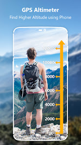
Accurate Altimeter Barometer App
Altimeter GPS is an accurate altitude meter app for height measurement above sea level that measures my current elevation, GPS location, Localization coordinates latitude and longitude. You can calibrate your altitude by refresh button. Measure the height of your traveling places and during hiking and record your Altitude history to share with images. No internet connection is required as it works even offline. If device is equipped with pressure sensor, then it can calculate accurate measurement of barometric pressure.
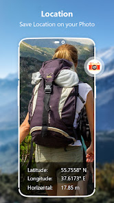
Save History of Altitudes
My altitude elevation changes at a high altitude above ground level. To measure and record the latest elevation/altitude and atmospheric pressure around you using Altimeter and Barometer, you can take pictures of yourself and save these altitude heights. Using this Altimeter barometer pressure app you can take photo at different air pressures and save all these elevation records in a map chart. Altimeter widget will provide you with all of these altimeter elevation images. It works offline and online and also saves Altitude history with charts.
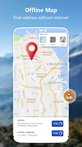
All Map Modes with Localization Coordinates
My Altitude Altimeter app has GPS Map and Offline Map. Ultimate map tracking your changing location trajectory. This map has Terrain, Hybrid and Satellite mode to view your best map.
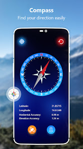
GPS Compass – Direction Map
Tap to view your accurate direction with this smart compass with gps for Android. Also you will find guidance with latitude and longitude. GPS map compass is the most accurate smart compass map app for outdoor activities like hilly areas and airplanes.
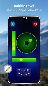
Bubble Level
Bubble level is plumb level tool also known as tilt meter, for precisely horizontally and vertical labelling in fields such as carpentry and construction. This precise level meter displays the data as accurate real level meter would.
Enjoy with this altimeter app!
Thank You for Your Support & Cooperation!
GPS Altimeter Altitude Compass is the best tracking Trekker, Hikers, Rock climbers and GlobeTrotters. While hiking gps or climbing, or while traveling with a car or bicycle, you can instantly discover your location and measuring altitude, direction, address infor, atmospheric pressure and geographic coordinates and adds this value to the photo. Discover my altitude for the places marked on the map. You can share the photos you take with your loved ones, including your altitude, address information and geographic coordinates. Digital Altimeter pro & GPS Altitude is a multipurpose app equipped with features like altimeter, barometer, inclinometer, level meter, GPS Map, compass over your satellite location. It works online & offline.
My elevation & altitudes app turns your smart phone into multi-function altimeter to get accurate altitude. Determine the altitude of your current location, exact heading on your current route or any place marked on the Map based on the GPS tracking.
Let us introduce you to key features of the app:
Accurate Altimeter Barometer App
Altimeter GPS is an accurate altitude meter app for height measurement above sea level that measures my current elevation, GPS location, Localization coordinates latitude and longitude. You can calibrate your altitude by refresh button. Measure the height of your traveling places and during hiking and record your Altitude history to share with images. No internet connection is required as it works even offline. If device is equipped with pressure sensor, then it can calculate accurate measurement of barometric pressure.
Save History of Altitudes
My altitude elevation changes at a high altitude above ground level. To measure and record the latest elevation/altitude and atmospheric pressure around you using Altimeter and Barometer, you can take pictures of yourself and save these altitude heights. Using this Altimeter barometer pressure app you can take photo at different air pressures and save all these elevation records in a map chart. Altimeter widget will provide you with all of these altimeter elevation images. It works offline and online and also saves Altitude history with charts.
All Map Modes with Localization Coordinates
My Altitude Altimeter app has GPS Map and Offline Map. Ultimate map tracking your changing location trajectory. This map has Terrain, Hybrid and Satellite mode to view your best map.
GPS Compass – Direction Map
Tap to view your accurate direction with this smart compass with gps for Android. Also you will find guidance with latitude and longitude. GPS map compass is the most accurate smart compass map app for outdoor activities like hilly areas and airplanes.
Bubble Level
Bubble level is plumb level tool also known as tilt meter, for precisely horizontally and vertical labelling in fields such as carpentry and construction. This precise level meter displays the data as accurate real level meter would.
Enjoy with this altimeter app!
Thank You for Your Support & Cooperation!
Updated on
Safety starts with understanding how developers collect and share your data. Data privacy and security practices may vary based on your use, region, and age. The developer provided this information and may update it over time.

No data shared with third parties
Learn more about how developers declare sharing

No data collected
Learn more about how developers declare collection

Data is encrypted in transit

Data can’t be deleted
Ratings and reviews
2.8
89 reviews

Zhen Wu
- Flag inappropriate
February 10, 2024
Worked moderately well since last summer but is force closing last couple days. Maybe my update. Phone suggests deep sleep or removal. I notice the icon logo changed here as opposed to the version I have.

Dave E
- Flag inappropriate
July 2, 2023
Not even close to the altitude I am right now. I know for a fact that it is between 1090-1100 ft. This says 628. That kind of inaccuracy results in auto delete.

Stacy Watson
- Flag inappropriate
April 5, 2023
Add popups severe with meters instead of feet as default with no obvious tweak to change it.


