Campos de Vuelo de España 2.0
1K+
Downloads

Everyone
info


About this app
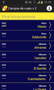
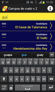
This application contains information on existing fields flight Spain where they can be found: airports, military roads, airfields, golf ultralight (ULM), forest trails, aterrizables areas, ...
It is a new application based on the earlier flight Golf Spain, and is called Campos Flight Spain v2. Solves the problem of map display each airfield and developments will be incorporated in future releases.
CAVEAT !!
This information IS NOT AN OFFICIAL PUBLICATION AERONAUTICA. This is a compilation of data obtained by D.Federico Iborra (ULM pilot) owners or managers of airfields. These data have been updated in the same way by Carlos Alonso (ULM pilot) for the development of this application. The content of this list should be used with caution and only as another source of information to be considered in planning a flight ultralight (ULM) or plane (PPL).
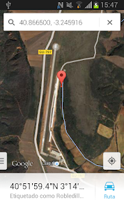
In certain cases the coordinate system is not accurate so the position of the airfields vary from a few hundred meters.
The information contained in this application comes from a variety of public and private sources consulted via web by the author.
The application fields Flight Spain v2, was designed and developed by Carlos Alonso in 2014.
It is a new application based on the earlier flight Golf Spain, and is called Campos Flight Spain v2. Solves the problem of map display each airfield and developments will be incorporated in future releases.
CAVEAT !!
This information IS NOT AN OFFICIAL PUBLICATION AERONAUTICA. This is a compilation of data obtained by D.Federico Iborra (ULM pilot) owners or managers of airfields. These data have been updated in the same way by Carlos Alonso (ULM pilot) for the development of this application. The content of this list should be used with caution and only as another source of information to be considered in planning a flight ultralight (ULM) or plane (PPL).
In certain cases the coordinate system is not accurate so the position of the airfields vary from a few hundred meters.
The information contained in this application comes from a variety of public and private sources consulted via web by the author.
The application fields Flight Spain v2, was designed and developed by Carlos Alonso in 2014.
Updated on
Safety starts with understanding how developers collect and share your data. Data privacy and security practices may vary based on your use, region and age. The developer provided this information and may update it over time.

No data shared with third parties
Learn more about how developers declare sharing

No data collected
Learn more about how developers declare collection
App support
About the developer
Carlos Alonso
carlos.desarrolloweb@gmail.com
Spain