Satellite View-GPS Navigation
Contains ads
50K+
Downloads

Everyone
info


About this app
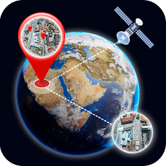
Satellite View-GPS Navigation, Live Earth Map with HD Street View offers live images and satellite views of your route, complete with driving directions. The live Earth map view provides real-time street maps with navigation to ensure you reach your destination on time. Whether you're on a world tour, visiting famous landmarks, or navigating your daily commute to home or work, this app assists you effectively. With 3D satellite views, you can see the best live Earth map of your house and find the shortest routes with traffic alerts for swift and quick arrivals.
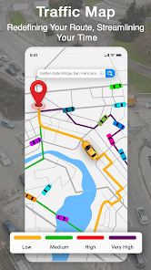
GPS Traffic Maps provide information on all connecting routes and alternative shortcuts to any location quickly. This live Earth map view isn't just for navigation but includes all the features needed for your journey. From weather alerts to a compass and speedometer, area measurement to a currency converter, and important nearby places to world wonders, every tool is available in Street View-GPS Navigation Live Earth Map with HD Street View.
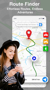
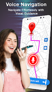
No need to worry if you're in a new city or country. Open the Live Earth map view and get live navigation maps of your surroundings with just a few clicks. The 3D satellite view with live traffic alerts helps you find driving directions for live car navigation in street view maps. This GPS map identifies the best routes for a convenient journey. For your daily commute to office, school, or home, use the traffic map in Satellite View-GPS Navigation Live Earth Map with HD Street View to find the shortest route with live car navigation. The voice navigation feature provides voice instructions to assist while driving.
Features of Satellite View-GPS Navigation Live Earth Maps with 3D Street View:
● Voice GPS and driving directions help you find route maps and navigate locations on live maps.
● Access Live Earth Map with 3D street view. Get GPS live traffic updates with satellite road maps.
● Locate nearby places like schools, hospitals, and government offices, and get accurate driving directions.
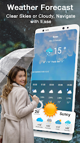
● Daily weather forecast to plan your journey.
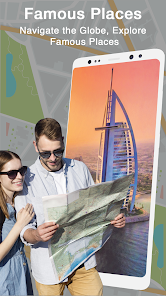
● Explore famous places on the Live Earth Map.
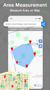
● Use the Area Measurement Calculator to measure areas and distances on GPS Maps.
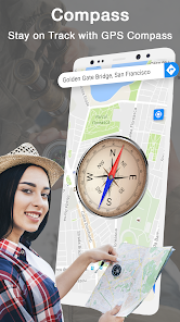
● Digital compass for map directions.
● GPS speedometer.
Multiple map views, including hybrid, terrain, satellite, and street view, make navigation easy. Satellite View-GPS Navigation Live Earth Map with 3D Street View is your best travel companion for planning trips. It includes every necessary feature, such as weather forecasts and a precise compass. The unique Area Measurement feature allows you to measure any area on real-time street maps by tapping points.
The standout feature of this app is aerial imagery from satellites, offering the best satellite views of any location with detailed driving directions. Search for nearby important places like restaurants, hospitals, shopping malls, and airports using the satellite and street views in this Live Earth maps app.
Download Satellite View-GPS Navigation Live Earth Maps with 3D Street View and enjoy an unparalleled navigation experience!
GPS Traffic Maps provide information on all connecting routes and alternative shortcuts to any location quickly. This live Earth map view isn't just for navigation but includes all the features needed for your journey. From weather alerts to a compass and speedometer, area measurement to a currency converter, and important nearby places to world wonders, every tool is available in Street View-GPS Navigation Live Earth Map with HD Street View.
No need to worry if you're in a new city or country. Open the Live Earth map view and get live navigation maps of your surroundings with just a few clicks. The 3D satellite view with live traffic alerts helps you find driving directions for live car navigation in street view maps. This GPS map identifies the best routes for a convenient journey. For your daily commute to office, school, or home, use the traffic map in Satellite View-GPS Navigation Live Earth Map with HD Street View to find the shortest route with live car navigation. The voice navigation feature provides voice instructions to assist while driving.
● Voice GPS and driving directions help you find route maps and navigate locations on live maps.
● Access Live Earth Map with 3D street view. Get GPS live traffic updates with satellite road maps.
● Locate nearby places like schools, hospitals, and government offices, and get accurate driving directions.
● Daily weather forecast to plan your journey.
● Explore famous places on the Live Earth Map.
● Use the Area Measurement Calculator to measure areas and distances on GPS Maps.
● Digital compass for map directions.
● GPS speedometer.
Multiple map views, including hybrid, terrain, satellite, and street view, make navigation easy. Satellite View-GPS Navigation Live Earth Map with 3D Street View is your best travel companion for planning trips. It includes every necessary feature, such as weather forecasts and a precise compass. The unique Area Measurement feature allows you to measure any area on real-time street maps by tapping points.
The standout feature of this app is aerial imagery from satellites, offering the best satellite views of any location with detailed driving directions. Search for nearby important places like restaurants, hospitals, shopping malls, and airports using the satellite and street views in this Live Earth maps app.
Download Satellite View-GPS Navigation Live Earth Maps with 3D Street View and enjoy an unparalleled navigation experience!
Updated on
Safety starts with understanding how developers collect and share your data. Data privacy and security practices may vary based on your use, region and age The developer provided this information and may update it over time.

No data shared with third parties
Learn more about how developers declare sharing

No data collected
Learn more about how developers declare collection

Data is encrypted in transit
What's new
Bug Fixes
App support
About the developer
Zeeshan Ashiq
zashiq431@gmail.com
Pakistan
undefined