

Air Navigation Pro
In-app purchases

3.7star
4.97K reviews
100K+
Downloads

Everyone
info


About this app
Discover our flight planning & real-time navigation app for free for 28 days!
- Everything you need to fly around the world
- Plan your flight in a few minutes
- Fly relaxed with up-to-date information
Air Navigation Pro is a high-quality flight assistant app for pilots worldwide. Benefit from the following main features:
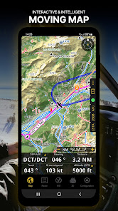
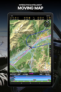
MOVING MAP
Plan and navigate using our interactive moving map. Choose between aeronautical charts, satellite or our vector map as a background. On top of that, the moving map displays waypoints, NOTAM, obstacles, and airspaces from our comprehensive, always up-to-date worldwide aeronautical database. Tap on any waypoint directly on the map to easily create a route. Personalise the values shown on the navbar to have exactly the information you need: altitude, vertical speed, bearing, distance to the next waypoint, ETA calculations, etc. Choose the airport departure and arrival procedures for your route to have them also displayed on top of the moving map.
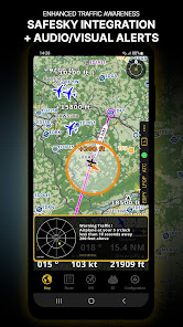
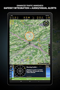
ENHANCED TRAFFIC AWARENESS
Get visual and audio alerts in all languages for nearby conflicting traffic. Choose your preferred traffic icon between generic, aircraft, or TCAS symbols. Your safety is important to us, which is why we partnered with SafeSky to ensure our users have live traffic data during their flight. Benefit from the native integration with SafeSky included in our new Smart Lite, Smart Classic, and Smart Advanced subscriptions—a two-in-one package!
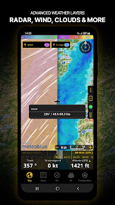
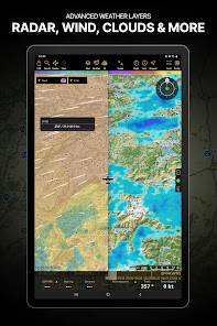
ADVANCED WEATHER LAYERS
In addition to the basic weather reports of winds and TAF/METAR for your flight, subscribers of the Smart Advanced plan can activate see-through weather layers on top of the moving map. Available layers include rain radar, wind, pressure, clouds and rain, visibility, gust, and additionally for Germany, Switzerland, Austria and the Balkans, GAFOR reports. Tap on any point on the map to see the weather information for that area. Review the weather forecast for up to three days ahead.
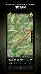
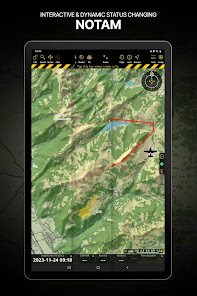
NOTAM
After creating your route, set the departure time in the future to have the moving map display the NOTAM active for that specific time. NOTAM on the map change colour dynamically based on their status.
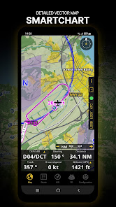
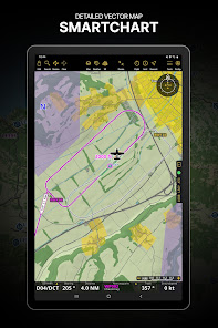
SMARTCHART
Our cutting-edge SmartChart is a highly detailed and intelligent vector-based map that adapts to your needs, providing you with adequate information at any zoom level. The SmartChart optimises the display of shadows to easily distinguish between valleys and mountains, and the text remains perfectly aligned, guaranteeing optimal readability. Including the latest significant improvements with forests and detailed airport information.
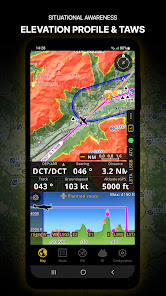
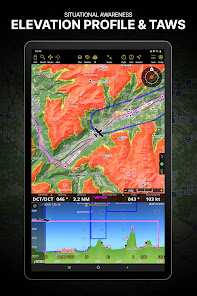
ELEVATION PROFILE & SYNTHETIC VIEW
Enable the profile view below the navbar for enhanced situational awareness of the elevation ahead of you or along your route. Choose the corridor width between 0 to 5 NM and overlay options: airspaces, NOTAM, obstacles, wind components, populated places, etc. Switch to the synthetic view for additional terrain information, plus an artificial horizon with altitude and vertical speed indicators. This function can also be used to pan around while preparing for your flight. Activate TAWS on the moving map as well as on the synthetic view.
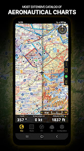
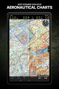
AERONAUTICAL CHARTS & APPROACH CHARTS
We offer the most extensive worldwide catalog of aeronautical charts, including the ICAO charts. Have the georeferenced approach charts displayed on top of the moving map or the synthetic view.
BRIEFING
Prepare your flight with our briefing section by creating documents with NOTAM and weather charts & stations relevant to your planned route. Optimise time by creating an aircraft profile which will be used in the Briefing section to pre-fill for you the ATC Flight Plan and calculate the W&B.
AND SO MUCH MORE!
A subscription allows you to use the app on three devices. We recommend creating an Air Navigation account for improved device management. Refer to our user manual on our website: www.airnavigation.aero for more information.
- Everything you need to fly around the world
- Plan your flight in a few minutes
- Fly relaxed with up-to-date information
Air Navigation Pro is a high-quality flight assistant app for pilots worldwide. Benefit from the following main features:
MOVING MAP
Plan and navigate using our interactive moving map. Choose between aeronautical charts, satellite or our vector map as a background. On top of that, the moving map displays waypoints, NOTAM, obstacles, and airspaces from our comprehensive, always up-to-date worldwide aeronautical database. Tap on any waypoint directly on the map to easily create a route. Personalise the values shown on the navbar to have exactly the information you need: altitude, vertical speed, bearing, distance to the next waypoint, ETA calculations, etc. Choose the airport departure and arrival procedures for your route to have them also displayed on top of the moving map.
ENHANCED TRAFFIC AWARENESS
Get visual and audio alerts in all languages for nearby conflicting traffic. Choose your preferred traffic icon between generic, aircraft, or TCAS symbols. Your safety is important to us, which is why we partnered with SafeSky to ensure our users have live traffic data during their flight. Benefit from the native integration with SafeSky included in our new Smart Lite, Smart Classic, and Smart Advanced subscriptions—a two-in-one package!
ADVANCED WEATHER LAYERS
In addition to the basic weather reports of winds and TAF/METAR for your flight, subscribers of the Smart Advanced plan can activate see-through weather layers on top of the moving map. Available layers include rain radar, wind, pressure, clouds and rain, visibility, gust, and additionally for Germany, Switzerland, Austria and the Balkans, GAFOR reports. Tap on any point on the map to see the weather information for that area. Review the weather forecast for up to three days ahead.
NOTAM
After creating your route, set the departure time in the future to have the moving map display the NOTAM active for that specific time. NOTAM on the map change colour dynamically based on their status.
SMARTCHART
Our cutting-edge SmartChart is a highly detailed and intelligent vector-based map that adapts to your needs, providing you with adequate information at any zoom level. The SmartChart optimises the display of shadows to easily distinguish between valleys and mountains, and the text remains perfectly aligned, guaranteeing optimal readability. Including the latest significant improvements with forests and detailed airport information.
ELEVATION PROFILE & SYNTHETIC VIEW
Enable the profile view below the navbar for enhanced situational awareness of the elevation ahead of you or along your route. Choose the corridor width between 0 to 5 NM and overlay options: airspaces, NOTAM, obstacles, wind components, populated places, etc. Switch to the synthetic view for additional terrain information, plus an artificial horizon with altitude and vertical speed indicators. This function can also be used to pan around while preparing for your flight. Activate TAWS on the moving map as well as on the synthetic view.
AERONAUTICAL CHARTS & APPROACH CHARTS
We offer the most extensive worldwide catalog of aeronautical charts, including the ICAO charts. Have the georeferenced approach charts displayed on top of the moving map or the synthetic view.
BRIEFING
Prepare your flight with our briefing section by creating documents with NOTAM and weather charts & stations relevant to your planned route. Optimise time by creating an aircraft profile which will be used in the Briefing section to pre-fill for you the ATC Flight Plan and calculate the W&B.
AND SO MUCH MORE!
A subscription allows you to use the app on three devices. We recommend creating an Air Navigation account for improved device management. Refer to our user manual on our website: www.airnavigation.aero for more information.
Updated on
Safety starts with understanding how developers collect and share your data. Data privacy and security practices may vary based on your use, region and age. The developer provided this information and may update it over time.

No data shared with third parties
Learn more about how developers declare sharing

This app may collect these data types
Location, Personal info and Device or other IDs

Data is encrypted in transit

You can request that data be deleted
Ratings and reviews
3.7
3.63K reviews

Corrie Baker
- Flag inappropriate
12 September 2025
Subscriptions are fine but also offering a one off lifetime payment would certainly open more doors for users like myself who would purchase it. I think people would rather pay a one off payment over a subscription plan.
Air Navigation SA
14 October 2025
Hello Corrie,
Thank you for sharing your thoughts! We understand your preference for a one-time purchase. Our subscription model ensures continuous updates and improvements, but we truly appreciate your feedback.
Blue skies,
Your Air Navigation Pro Team

SUN
- Flag inappropriate
17 October 2025
Not able to go back after adding user waypoint as the "back" option is way too high on top left bezel of phone. Not able to add any user waypoint.
2 people found this review helpful
Air Navigation SA
23 October 2025
Hello SUN,
We're sorry about this. This issue has been resolved and will be part of the new version, which will be released soon.
Thank you for your patience and understanding.
Blue skies,
Your Air Navigation Pro Team

Puneet Pasricha
- Flag inappropriate
7 September 2025
Unable to add user way points as the ' Back/ Close' tabs have stopped working or responding.
Air Navigation SA
14 October 2025
Hello Puneet,
We’re sorry about this issue affecting Android smartphones. The bug has already been fixed, and the update will be included in the upcoming version. Thank you for your patience and understanding!
Blue skies,
Your Air Navigation Pro Team
What's new
• New map styles
• Important map items light up when tapped
• Frequencies now in main airport tab for quicker access
• Improved Sensors menu UI
• Added AHRS support over GDL90 external boxes
• Enhanced flight simulator support (XGPS, XTRAFFIC, XATT)
• Import documents not linked to specific aerodromes
• Cleaner Waypoint Popover with hidden empty tabs
• Replaced OSM with Mapbox for faster searches
• Better poor GSM network tolerance
• Various bug fixes and performance improvements
App support
About the developer
Air Navigation SA
support@airnavigation.aero
Chemin des Fossaux 10
1443 Villars-Champvent
Switzerland
+41 79 429 52 76


