GalileoPVT
4.2star
128 reviews
10K+
Downloads

Everyone
info
About this app
Visualise Galileo satellite navigation signals on your Android device!
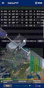
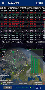
For compatible devices that support the European Galileo Satellite Navigation System, GalileoPVT uses the raw signals from visible Galileo satellites to calculate your position, independent of the processed fix supplied by the device GNSS chipset.
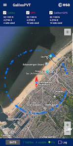
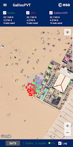
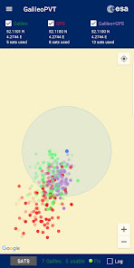
A comparison can be made with the GPS and internal Android calculated locations, with all points plotted on the map. Received signals are listed in a table (including signals from Glonass and Beidou, if supported by the device, as well as GPS and Galileo).
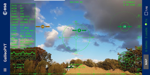
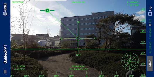
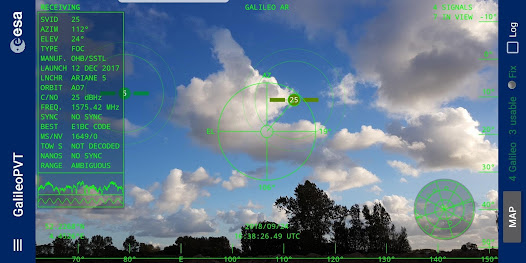
An augmented reality view allows you to visualise the position of live Galileo satellites in the sky, as viewed by the device camera. This feature also works on devices that do not support Galileo, by plotting the predicted satellite positions if no signals are received.
The raw signals can be logged to a file for post-processing, in CSV or NMEA format.
To use the app you will need to grant the following permissions:
Camera - for the Augmented Reality view
Location - to make use of the raw GNSS measurements and Android location
Storage - to save logfiles and to save and read back assistance data
Network - to download assistance data from the Google SUPL server
Please note: The augmented reality view will only work if your device has a magnetometer - most phones do, but not all. Check to see if the sky plot rotates as you turn the device.
Tested with the Samsung Galaxy S8+, Huawei P10 and Xiaomi Mi8. A list of devices that support Galileo can be found at the following address:
https://www.usegalileo.eu/EN/inner.html#data=smartphone
GalileoPVT was developed as an unofficial side project by engineers Tim and Paolo at the European Space Agency.
Please note that the text in the app is in English. For future releases we plan to add translations for some European languages, but as a small team of 3 people working on a volunteer basis, and without monetising the app, we do not have the resources to translate the app into all languages. We have not restricted the distribution of the app, as we hope it can be useful even if English is not your native language.
For compatible devices that support the European Galileo Satellite Navigation System, GalileoPVT uses the raw signals from visible Galileo satellites to calculate your position, independent of the processed fix supplied by the device GNSS chipset.
A comparison can be made with the GPS and internal Android calculated locations, with all points plotted on the map. Received signals are listed in a table (including signals from Glonass and Beidou, if supported by the device, as well as GPS and Galileo).
An augmented reality view allows you to visualise the position of live Galileo satellites in the sky, as viewed by the device camera. This feature also works on devices that do not support Galileo, by plotting the predicted satellite positions if no signals are received.
The raw signals can be logged to a file for post-processing, in CSV or NMEA format.
To use the app you will need to grant the following permissions:
Camera - for the Augmented Reality view
Location - to make use of the raw GNSS measurements and Android location
Storage - to save logfiles and to save and read back assistance data
Network - to download assistance data from the Google SUPL server
Please note: The augmented reality view will only work if your device has a magnetometer - most phones do, but not all. Check to see if the sky plot rotates as you turn the device.
Tested with the Samsung Galaxy S8+, Huawei P10 and Xiaomi Mi8. A list of devices that support Galileo can be found at the following address:
https://www.usegalileo.eu/EN/inner.html#data=smartphone
GalileoPVT was developed as an unofficial side project by engineers Tim and Paolo at the European Space Agency.
Please note that the text in the app is in English. For future releases we plan to add translations for some European languages, but as a small team of 3 people working on a volunteer basis, and without monetising the app, we do not have the resources to translate the app into all languages. We have not restricted the distribution of the app, as we hope it can be useful even if English is not your native language.
Updated on
Safety starts with understanding how developers collect and share your data. Data privacy and security practices may vary based on your use, region and age The developer provided this information and may update it over time.

No data shared with third parties
Learn more about how developers declare sharing

No data collected
Learn more about how developers declare collection
Ratings and reviews
4.2
127 reviews

Jacob Bingham (UFTS)
- Flag inappropriate
26 March 2024
Really cool app, the only one I know of besides GNSS Logger and GPS Test to use Android's Raw GNSS Measurements, the AR mode is really neat, the developers certainly have a sense of humor and I love it. Unfortunately, I can't get it to calculate a PVT solution, GPS, Galileo, or Custom, even though GNSS Logger does. Very rarely it will get a fix a few kilometers from my location…

Peter Bremer
- Flag inappropriate
8 October 2023
It calculates speed based on difference of location divided by difference in time. That is not how GPS based systems determine speed, that is Doppler based which is over 5 times more accurate. No idea whether Galileo speed is also Doppler based.
1 person found this review helpful

Olu Ogunbiyi
- Flag inappropriate
11 May 2020
The most interesting feature of this app for me is SAR which I think could probably have helped to send quicker rescue for my son when he was drowning on the beach outside Toronto during our 2016 summer holiday. 5* from me and I believe it will benefit humanity a great deal.
4 people found this review helpful
What's new
- Added translations for Spanish and Italian
- Bugfix for occasional startup crash
- Bugfix for occasional startup crash