
板橋区防災マップ
5K+
Downloads

Everyone
info


About this app
Itabashi Ward Disaster Prevention Map, an Android application based on the disaster prevention map distributed by the ward office. Disaster prevention facilities such as evacuation shelters are posted on the disaster prevention map, and in addition to being able to check the map on an Android device, it is also possible to display the current location, search the surrounding area, and register the destination.
Since the "Itabashi Ward Disaster Prevention Map" is saved on the terminal, you can browse the map even when there is no internet communication environment, and you can use the GPS function of the terminal to display your current location on the map (current location display), and the area around your current location. By searching for information such as evacuation shelters and evacuation areas (peripheral search function) and registering destinations in advance, it is possible to display the straight line (guidelines) connecting the current location and the destination and the direction of the destination. Is possible.
* This app does not provide a function to use location information in the background.
■ "Itabashi Ward Disaster Prevention Map"
■ Guides such as "Disaster Prevention Guidebook"
■ Browsing function of the above contents
■ Current location display function by GPS * Background location information is not used.
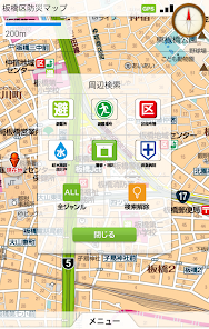
■ Peripheral search function
(Select from 6 items such as evacuation shelters and evacuation areas, and display the names and distances in order from the center of the displayed map)
■ Destination registration function
(Up to 20 locations, surrounding search results or arbitrary points on the map can be specified and registered)
■ Destination direction guidance function
(Displays the straight line (guideline) connecting the destination and the current location and the straight line distance, and displays the locus point while moving)
■ Direction confirmation function
(The current direction is displayed using the standard compass function of the terminal, and the destination direction is indicated by an arrow in the turn signal mode)
Compatible with Android OS 4.0 and above.
(Not compatible with Android tablet devices larger than 6 inches.)
* Operation is not guaranteed for all models.
Since the file size is about 40MB, it is recommended to use a Wi-Fi network during installation.
This application is free. (Communication charges for downloading the application, communication charges for browsing external link pages, and call charges for calling phone numbers will be charged separately).
Planning and operation
Itabashi Ward and Shobunsha Publications, Inc.
Product development
Itabashi Ward and Shobunsha Publications, Inc.
Map information provided
Itabashi Ward and Shobunsha Publications, Inc.
Guide information provided
Itabashi Ward and Shobunsha Publications, Inc.
Since the "Itabashi Ward Disaster Prevention Map" is saved on the terminal, you can browse the map even when there is no internet communication environment, and you can use the GPS function of the terminal to display your current location on the map (current location display), and the area around your current location. By searching for information such as evacuation shelters and evacuation areas (peripheral search function) and registering destinations in advance, it is possible to display the straight line (guidelines) connecting the current location and the destination and the direction of the destination. Is possible.
* This app does not provide a function to use location information in the background.
■ "Itabashi Ward Disaster Prevention Map"
■ Guides such as "Disaster Prevention Guidebook"
■ Browsing function of the above contents
■ Current location display function by GPS * Background location information is not used.
■ Peripheral search function
(Select from 6 items such as evacuation shelters and evacuation areas, and display the names and distances in order from the center of the displayed map)
■ Destination registration function
(Up to 20 locations, surrounding search results or arbitrary points on the map can be specified and registered)
■ Destination direction guidance function
(Displays the straight line (guideline) connecting the destination and the current location and the straight line distance, and displays the locus point while moving)
■ Direction confirmation function
(The current direction is displayed using the standard compass function of the terminal, and the destination direction is indicated by an arrow in the turn signal mode)
Compatible with Android OS 4.0 and above.
(Not compatible with Android tablet devices larger than 6 inches.)
* Operation is not guaranteed for all models.
Since the file size is about 40MB, it is recommended to use a Wi-Fi network during installation.
This application is free. (Communication charges for downloading the application, communication charges for browsing external link pages, and call charges for calling phone numbers will be charged separately).
Planning and operation
Itabashi Ward and Shobunsha Publications, Inc.
Product development
Itabashi Ward and Shobunsha Publications, Inc.
Map information provided
Itabashi Ward and Shobunsha Publications, Inc.
Guide information provided
Itabashi Ward and Shobunsha Publications, Inc.
Updated on
Safety starts with understanding how developers collect and share your data. Data privacy and security practices may vary based on your use, region and age The developer provided this information and may update it over time.

No data shared with third parties
Learn more about how developers declare sharing

No data collected
Learn more about how developers declare collection
What's new
掲載情報を更新しました。


