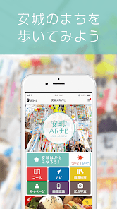
安城ARナビで楽しく散策!魅力を再発見!
1K+
Downloads

Everyone
info


About this app
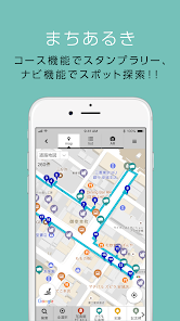
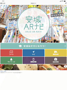
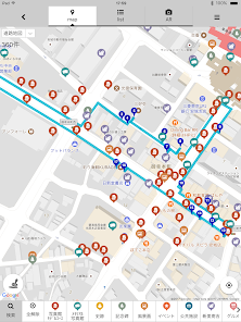
There is a ``Course'' function that takes you around recommended sights on a course, and a ``Navi'' function that guides you to the desired point using a map or list.
There are a variety of recommended courses, including a stroll through Andersen's fairy tales, a tour of bronze statues, stone statues, and stone monuments.
Each point has detailed explanations that are easy to understand, so you can enjoy exploring even places you don't know.
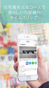
In AR mode, you can display past photos of Anjo City on top of the current cityscape and compare them.
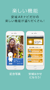
The "Anjo Memorial Photo Gallery" has over 200 photographs of the townscape of Anjo from around 1955 to 1955.
AR navigation will take you to the exact location where the photo was taken.
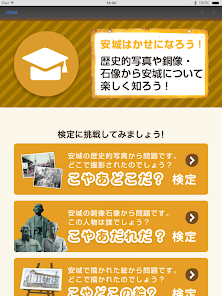
The test asks various questions related to Anjo.
You can also check the weather information for Anjo City.
Explore Anjo City and discover new attractions using the Anjo City AR Navi, which has become even more fun with the addition of a function that displays the number of steps you took that day at the top.
Supervision: Anjo City
●Compatible with "Google Fit - Fitness Tracking", there is a function that displays the number of steps taken that day. Displays the number of steps taken that day. (Tablets are not supported) *In order to display step counts, you need to select the Google account to be used with the "Google Fit - Fitness Tracking" app. If not selected, the number of steps cannot be displayed.
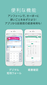
●You can send the location to the car navigation system using NaviCon. For more information about "NaviCon", please see the support page.
https://navicon.com
*NaviCon is a registered trademark of DENSO Corporation.
【Notes】
Due to GPS performance, slight errors may occur. During course guidance, we will use the GPS function to obtain location information. Please note that acquiring location information using the GPS function may consume more battery power than usual.
・It is extremely dangerous to operate or stare at a mobile phone while moving. Stop in a safe place before operating.
・This app will download the data necessary for operation at startup.
Please note that communication charges may be high depending on your carrier's contract plan.
[Recommended model]
Android 9 or higher recommended
*Limited to models with built-in GPS.
[Change/suspension/termination of app]
The content, functions, operating methods, and other operating methods of this app may be changed without prior notice to customers and for any reason, and the provision of this app may be suspended or terminated. It is also possible to do so. In this case, we will not be held responsible for any changes, interruptions, or cancellations.
【Copyright】
Individual information (text, photos, illustrations, etc.) posted on this app is subject to copyright. In addition, this entire app is also subject to copyright as an edited work, and both are protected by copyright law. Copying or diversion without permission is prohibited, except in cases permitted by copyright law, such as "copying for personal use" or "quoting."
There are a variety of recommended courses, including a stroll through Andersen's fairy tales, a tour of bronze statues, stone statues, and stone monuments.
Each point has detailed explanations that are easy to understand, so you can enjoy exploring even places you don't know.
In AR mode, you can display past photos of Anjo City on top of the current cityscape and compare them.
The "Anjo Memorial Photo Gallery" has over 200 photographs of the townscape of Anjo from around 1955 to 1955.
AR navigation will take you to the exact location where the photo was taken.
The test asks various questions related to Anjo.
You can also check the weather information for Anjo City.
Explore Anjo City and discover new attractions using the Anjo City AR Navi, which has become even more fun with the addition of a function that displays the number of steps you took that day at the top.
Supervision: Anjo City
●Compatible with "Google Fit - Fitness Tracking", there is a function that displays the number of steps taken that day. Displays the number of steps taken that day. (Tablets are not supported) *In order to display step counts, you need to select the Google account to be used with the "Google Fit - Fitness Tracking" app. If not selected, the number of steps cannot be displayed.
●You can send the location to the car navigation system using NaviCon. For more information about "NaviCon", please see the support page.
https://navicon.com
*NaviCon is a registered trademark of DENSO Corporation.
【Notes】
Due to GPS performance, slight errors may occur. During course guidance, we will use the GPS function to obtain location information. Please note that acquiring location information using the GPS function may consume more battery power than usual.
・It is extremely dangerous to operate or stare at a mobile phone while moving. Stop in a safe place before operating.
・This app will download the data necessary for operation at startup.
Please note that communication charges may be high depending on your carrier's contract plan.
[Recommended model]
Android 9 or higher recommended
*Limited to models with built-in GPS.
[Change/suspension/termination of app]
The content, functions, operating methods, and other operating methods of this app may be changed without prior notice to customers and for any reason, and the provision of this app may be suspended or terminated. It is also possible to do so. In this case, we will not be held responsible for any changes, interruptions, or cancellations.
【Copyright】
Individual information (text, photos, illustrations, etc.) posted on this app is subject to copyright. In addition, this entire app is also subject to copyright as an edited work, and both are protected by copyright law. Copying or diversion without permission is prohibited, except in cases permitted by copyright law, such as "copying for personal use" or "quoting."
Updated on
Safety starts with understanding how developers collect and share your data. Data privacy and security practices may vary based on your use, region and age The developer provided this information and may update it over time.

No data shared with third parties
Learn more about how developers declare sharing

No data collected
Learn more about how developers declare collection
What's new
今回のアップデート内容は以下になります。
・軽微な不具合を修正しました。
引き続き、アプリをお楽しみ下さいませ。
・軽微な不具合を修正しました。
引き続き、アプリをお楽しみ下さいませ。


