
Way of St. James in Galicia
50K+
Downloads

Everyone
info
About this app
Part of the Smart Camino project, it is designed to be your faithful companion and pocket guide throughout your trip; this pioneering state-of-the-art mobile app aspires to become the leader in its segment.
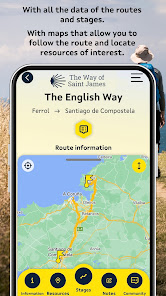
It provides information on all the Way of St James routes from the Galician border onwards: the French Way, the Fisterra–Muxía Way, the South-East -Silver Route Way, the Portuguese Way, the Primitive Way, the Northern Way, the Route of the Sea of Arousa and River Ulla and the Winter Way.
You will have full information at your fingertips in real time, as and when you need it:
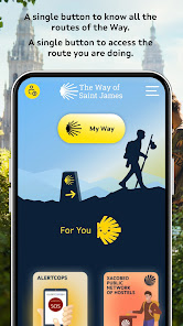
— Access to full details of the official routes for each way. What’s more, registered users will have access to personalised routes via the portal.
— Details of the network of official hostels, including their facilities, opening times, location, telephone number and photo galleries
— Access to details of events (festivals, concerts, workshops, etc.)
— Detailed information (description, locations photographs, etc.) of all tourist attractions and amenities
— Information on where to eat, stay and places to visit, etc.
— Alerts of offers posted by tourism establishments
— Real time weather updates provided by MeteoGalicia
— Addresses and contact details for health centres and emergency services
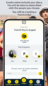
— My diary will allow you to save the most memorable moments of your experience on the Way (text notes, photographs) which you can later convert into your very own digital book via the My Experience function on the portal
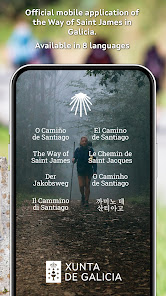
— Available in the following languages: Galician, Spanish, English, German, French, Italian and Portuguese
What’s more, most of the functions do not require a mobile signal.
It provides information on all the Way of St James routes from the Galician border onwards: the French Way, the Fisterra–Muxía Way, the South-East -Silver Route Way, the Portuguese Way, the Primitive Way, the Northern Way, the Route of the Sea of Arousa and River Ulla and the Winter Way.
You will have full information at your fingertips in real time, as and when you need it:
— Access to full details of the official routes for each way. What’s more, registered users will have access to personalised routes via the portal.
— Details of the network of official hostels, including their facilities, opening times, location, telephone number and photo galleries
— Access to details of events (festivals, concerts, workshops, etc.)
— Detailed information (description, locations photographs, etc.) of all tourist attractions and amenities
— Information on where to eat, stay and places to visit, etc.
— Alerts of offers posted by tourism establishments
— Real time weather updates provided by MeteoGalicia
— Addresses and contact details for health centres and emergency services
— My diary will allow you to save the most memorable moments of your experience on the Way (text notes, photographs) which you can later convert into your very own digital book via the My Experience function on the portal
— Available in the following languages: Galician, Spanish, English, German, French, Italian and Portuguese
What’s more, most of the functions do not require a mobile signal.
Updated on
Safety starts with understanding how developers collect and share your data. Data privacy and security practices may vary based on your use, region and age The developer provided this information and may update it over time.


What's new
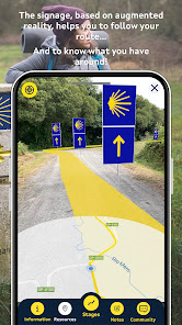
Incorporation of the topographic profile and information on cumulative altitudes and elevations of routes and stages, as well as the irregularities of the route in augmented reality. Contextualised meteorological information in augmented reality and in the inventory of tourism resources. Improved accessibility: keyboard navigation and screen reader integration. Other improvements: map type selector, link to the start, and stage length, difficulty and time data.


