
PNW Current Atlas
In-app purchases
3.5star
26 reviews
1K+
Downloads

Everyone
info


About this app
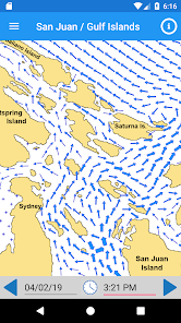
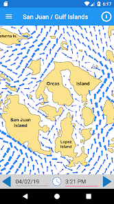
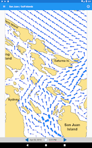
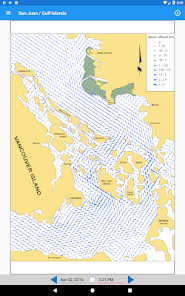
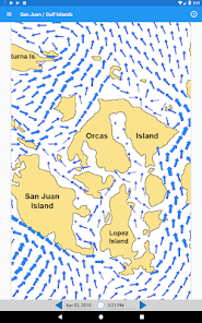
The PNW Current Atlas brings a fast and easy way to view Pacific Northwest current prediction charts for the Juan de Fuca Strait / Strait of Georgia regions on your mobile device. This includes complete coverage of the US San Juan Islands, the Canadian Gulf Islands, and the Eastern Juan de Fuca Strait and more.
This digital current atlas includes predictions for the current year with free yearly updates so that you never have to buy a reference or look-up table ever again.
Features:
◆ View any date/time within a tide cycle, past or future (within the current year)
◆ Easily jump to the prediction closest to Now with a single tap
◆ Easily move forwards or backwards through prediction time by tapping or swiping
◆ Zoom into predictions to see more detail
◆ Works offline - no Internet connection needed!
◆ Includes all predictions for the current calendar year with free yearly updates
◆ and more...
Updated on
Safety starts with understanding how developers collect and share your data. Data privacy and security practices may vary based on your use, region and age. The developer provided this information and may update it over time.

No data shared with third parties
Learn more about how developers declare sharing

No data collected
Learn more about how developers declare collection
Ratings and reviews
3.5
25 reviews

Andrew Kinsman
- Flag inappropriate
27 August 2025
This has been very helpful., I've used this for years sailing between islands. Much easier using this than the current charts and trying to figure out what it will be like at the time of crossing. Made great time going to and from Sucia from Anacortes. Would love to see more detail to determine best paths for where current is strongest other than guessing in the center.
1 person found this review helpful

Colin Stepney
- Flag inappropriate
7 May 2020
Exceptional and Simple. The app does exactly what it's supposed to - and that isn't much. What it is supposed to do though, providing tide charts for the Salish Sea, it does perfectly. While it's rudimentary, it doesn't need to be anything more than what it currently is. The only point I can comment on is that I am excited to see more areas available, considering the cost, and maybe the ability to see tide times at specific locations. Perfect for quickly planning kayaking and sailing.
4 people found this review helpful

Jeff Anderson
- Flag inappropriate
- Show review history
24 May 2025
A bit pricy (especially since days it's based on is freely available from Canadian government), but has been very helpful for my frequent kayaking excursions in the San Juans Islands where I live currently. Sometimes I wish the resolution was better around particular local features but it gives you a good sense of currents at a macro level in the main channels and whatnot
What's new
Updated current predictions for 2025
App support
About the developer
Tinyoctopus, LLC
support@tinyoctopus.net
7001 Seaview Ave NW Ste 160 Pmb 642
Seattle, WA 98117-6021
United States
+1 206-552-8059